Background
“I’m getting married!” my friend told me. This was back in November of 2009, and as time crept forward to May of 2010, the month of the wedding, talks surfaced of the infamous bachelor party…Fortunately for me, my buddy has a much different take on bachelor parties than most, and almost immediately he turned to a backpacking trip.
Our minds quickly scrambled to places we had on our “tick-list:” Big Sur, Sequoia and Kings Canyon, the Grand Canyon, Kennedy Meadows, the Nine Peaks Challenge in the San Gorgonio Wilderness…. But the time of year, the Sierra snowpack, distances from Los Angeles, and ultimately, the need to cram our backpack trip into a weekend ruled out all those choices.
It was then we turned to areas more local like the San Gabriels and San Gorgonio Wilderness, but once again we were thwarted by the remains of the Station Fire and an unusually high snowpack for Southern California, respectively.
It was with all these choices negated, we turned back to a trip we had done nearly 2 years prior out on Santa Cruz Island, in which we would “traverse” from Prisoner’s Harbor and make our way to the more popular Scorpian Anchorage. A “traverse” of the island isn’t technically correct, seeing as only 25% of the island is open to backpackers. (The other 75% is owned by the Nature Conservancy).
While it seems like this choice was a “last resort,” it was quite the contrary. We were excited to head back to the Channel Islands, as both of us considered the hike we were to repeat to be among one of the most fantastic hikes either of us had ever done.
After some coordination on who would be coming along, we finally decided on the weekend of April 24th and 25th, 2010. Of the nearly 12 or so people initially invited, only four would be able to make the trip, with three of us making it all the way across the island.
Day 1 – April 24, 2010
When you head out to Santa Cruz Island, and you’re coming from Los Angeles, you’re waking up early and heading north on the 101 Freeway toward the hamlet town of Ventura in search of Island Packers.
http://www.islandpackers.com/
On the NPS website for the Channel Islands, it says you must make ferry arrangements prior to booking your campsite. This is especially important if you plan on crossing the island, as ferries to Prisoner’s Harbor are far more infrequent than to Scorpian Anchorage.
http://www.nps.gov/chis/planyourvisit/santa-cruz-island.htm
After checking in at Island Packers, we noticed two or our campanions were not to be found, although they had called shortly before. It turns out they were following signs to the harbor in Oxnard. Whoops! Luckily, they corrected their mistake and quickly changed directions, arriving with just enough time to spare.
It takes about an hour to cross over to Santa Cruz Island from Ventura. I don’t normally get seasick, but something hit me on this trip and I thought for sure I was going to hurl. I spent most of the trip leaning up against one of the poles with my eyes closed. That rolling I was feeling in my stomache didn’t subside until about 45 minutes after getting off the boat….ugh!
After getting off the ferry the NPS ranger greeted us at the dock just to go over the “rules o’ the land,” and it was here we met up with a group from the Nature Conservancy. They invited to tag along on a brief walk where they would be discussing some of the island’s history and flora. We signed some wavers, left our packs, and were off…
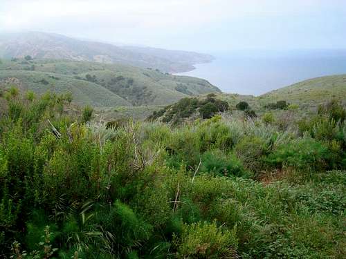
Immediately after heading over the Nature Conservancy side of the island there is a stark contrast to the harbor area. The area is extremely lush and vibrant. All kinds of flower were blooming, while we listened to quick facts about the island, and how at one time a group of lawyers or something from San Francisco purchased the whole thing, then one of them bought everyone else out, followed by the donation of a portion of the island being donated to the Nature Conservancy, and finally the park service taking control of 25% of the island via eminent domain. (I’m pretty sure all that’s right, anyway?)
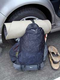
We tagged along for about a ½ hour, then decided it was time to turn around, get our packs, and make the 3 mile trudge to Del Norte Camp. It was at this point I noticed a stark contrast in packing styles between me and my partners.
Now I don’t consider myself a light-weight fanatic, but I do keep a list of all my backpacking gear with weights. My packing list for this trip looked like this:
Santa Cruz Island Backpack Trip - 15 miles - 2 days/1 night
Backpack
Golite Dawn 14
Sleeping Bag
SD Wicked Light (45Deg) 14
Sleeping Pad
PAD - CLOSED CELL 13
Tent
BD Firstlight 2 11
Stakes - Aluminum 3
Guylines 2
H20 - 6 liters 12
1 Liter playpus bladders???? 5.4
Gatorade Mix (per 2 days) 4
Kitchen/Stove
Jetboil 14
Jetboil Cannister 6.5
Spoon (plastic) 1
Knife - Swiss Army 3
Matches 1
Food - 2lbs/day 4
Extra Clothing
Base Layers
Long Underwear - REI Bottoms 7
Long Underwear - Capilene Top 5
Extra Socks 3
Outerwear
Manzella Gloves 1
Patagonia Down Sweater 6
Patagonia Specter Rainshll 6
Patagonia stretch fleece 7
Other
Camera 6.5
Cell Phone 5
Wallet 1
Toothbrush/Toothpaste 3
Compass 1.2
Map 1
Sunscreen 2
Headlamp 3
Toilet Paper 2
Bug Spray 2.2
Sanitary wash 3
First Aid Kit 3
Chapstick 1
Ibuprofen 1
GPS 6
Total Carrying Weight 18 167.8
Total Carrying Weight in Pounds 28.4875
When all was said and done, I weighed my pack and it came in underweight at right around 26lbs, and that was with a cup and a small amount of coffee. (I was worried about caffeine withdrawals!).
***Special note: Why 12lbs of water, you may ask (equivalent to 6 liters)? There is no water in between Prisoner’s Harbor and Scorpian Anchorage. Whatever water you bring has to last you for your hike!)***
My counterparts, however, had seemed to take the opposite method of packing…. My buddy who was getting married was going through some things before we set out, and I saw him pull out a full sized lantern from Brookstone! Man, I almost lost it when I saw that. Got a nice, good cramp I started laughing so hard. Later I was to find out our other camping buddy had brought a full 1.5 liter, thick, glass bottle of tequila. That thing had to weigh at least 4lbs by itself, though it did come in quite handy!
Anyway, we set out from Prisoner’s en route to Del Norte Camp. You leave Prisoner’s and head up a fireroad for about a mile, then bear left on a grassy trail that goes up and down a couple of dry ravines.
Eventually, you come to an intersection and go right to find Del Norte Camp nestled about 700 feet above the ocean. Three of the campsites huddled together under some large oak trees, with one campsite out by itself with a view of the ocean. (We took that one).
While setting up camp, we were visited by the famed island fox that scampers around. The fox was nearly hunted to extinction by some eagle or hawk, which has since been eradicated from the island. Now, with no known predators, the fox numbers have grown.
It was around now we decided to take a hike to what seemed like a great place for a lookout on the northern part of the island. It looked like it would be about 4 or 5 miles round trip, so I left everything behind except for the GPS.
We headed out of camp and made our way up to the fireroad that runs along the backbone of the island. We got to a point where a trail should have broken off from the road (prior to a prominent radio tower), but couldn’t find even the slightest glimpse of anything trail-like. We studied the map and GPS and decided to bushwack a little to the area we thought the trail should be. We came across a fence and thought better about jumping it, when lo-and-behold there was an opening in the fence that we hadn’t seen from the road. It looked like we were the first people to take this “trail” in a long time.
We made our way through some shrubs and were basically following what seemed to be an old water pipe. We started passing through these enormous stands of Manzanita.
The lady from the Nature Conservancy said because the island is isolated from the mainland, some plants experience gigantism. On the mainland Manzanita normally grows above 7000 feet, but here were some Manzanita at less than a 1000 feet in elevation the size of small trees! We made our way out to the point, and were disappointed that everything was so overgrown we couldn’t even get a good shot of the ocean cliffs below us. We turned around and made our way back to camp.
At night the lamp actually came in mighty handy, and the tequila bottle was drained….
Day 2 - April 25, 2010
The following morning we woke up in the middle of the clouds. Everything was soaked on the outside of our tents, and we found pawprints of our foxy friend in the dew on top of the picnic table, although we hadn’t left any food out.
![User Profile Image]() Day 2 Fog...
Day 2 Fog...
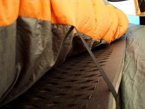
The night for me was restless to say the least. A couple of years prior I had purchased this ultralight Sierra Designs bag called the “Wicked Light,” which was supposedly rated to 45 degrees. Until this trip, I had never used it. When I had checked the weather, it said the low at night would be around 55 degrees, so I figured it was about as safe as could be for going ultralight, and so I would give it a try.
For those not familiar with the bag, the majority of the weight savings lies in there being NO FILL on the bottom of the bag. Basically it’s a down blanket with straps that go around your sleeping pad. This is fine if you don’t move, but if you turn to your side, cold air floods into the bag. Not a problem if it’s warm out, but definitely a problem if you’re trying to retain your heat.
I ended up putting on all my layers and even putting my legs inside my backpack inside of my sleeping bag to avoid drafts of air from seeping in. I kind of would fade in and out of sleep, and the worst part was when I woke up sore with a crook in my back or something, I couldn’t move because I would end up getting cold. So I would have to sit there, uncomfortable, and try to remain as still as possible. I vowed to never again use that bag unless the low was over 65 degrees.
While we didn’t wake up late, we lallygagged around camp, and I was glad I brought enough coffee to make a couple of cups after the sleepless night I’d had. We broke camp around 9:30am and set off on our 10 mile hike to Scorpian.
For about the first 2 miles we continued hiking in the clouds. Since we had done the trail before, we already knew about the one trail on the map that didn’t exist anymore. (The last time we had looked for it, and eventually gave up. This time, the ranger confirmed the trail no longer existed).
This is where the hike gets really interesting, as you pass through all these mini-ecosystems. Coastal views, oak groves, shrubby areas with foxes, and even a small stand of pine trees.
![User Profile Image]() Looking towards Montanon Ridge
Looking towards Montanon Ridge
Eventually around noon, the clouds started to break right where the road comes to a fork and you head on the trail towards Montanon Ridge. The trail dips slightly here, heading across this immense grassy area, following the side of a ravine on the eastern slope of the Montanon Ridge. As you walk through the grasses, one of my buddies was saying how you feel like you’re in that scene from Gladiator where his hand brushes over the grain.
You quickly notice the changing soil to be more volcanic as you ascend, and before you know it, you’re at the top of the ridge.
![User Profile Image]() At the base of the ridge
At the base of the ridge![User Profile Image]() Trail up the ridge
Trail up the ridge![User Profile Image]() Looking back down the ridge
Looking back down the ridge
We decided to take a quick break and realized not too far away was Montanon Peak. Once again, we left our packs and a mere 20 minutes later were standing atop the peak. It was here we met our first group of other hikers we had seen the whole day. We found the summit register with a litter of paper on the inside, but no pencil. We took some pictures, and I decided to run the ridge back to our backpacks. I think the whole side-trip took only about 35 or 40 minutes.
![User Profile Image]() Summit of Mt. Montanon
Summit of Mt. Montanon
After you pass over the ridge proper, you end up in another microclimate of red soil, like you’re in the Grand Canyon or something.
![User Profile Image]() Red Earth Country - Past the ridge
Red Earth Country - Past the ridge From there you pass into more of a pasture land of tall grasses, pass an old oil well, and eventually out to Scorpian Anchorage.
![User Profile Image]() The Grasslands...
The Grasslands...
You can immediately tell when you’re getting close to Scorpian because they’ll be troves of people, screaming high school kids, amongst other wack-a-doos. Granted, there were some people just out enjoying the surrounding area, but after basically hiking alone across an entire swath of the island, any of the above just seems out of place.
Right before you get to Scorpian you end up at the top of cliffs that surround the anchorage. We decided to stop at the top of the cliffs to avoid the crowds, soak up the views, and enjoy our last hour or so on the island. Not 5 minutes later a group of 15 or so people decided that the best place to sit was RIGHT NEXT TO US ON THE CLIFF. Then, a family of 6 or 10 decided the best place to take pictures was RIGHT WHERE WE WERE SITTING. Not kidding, I turned around and there were this girl and her mom not less than 1.5 feet from where I was sitting. I was totally in their picture, for sure. (Keep in mind this is a loooooooooong cliff with lots of places to take pictures).
![User Profile Image]() Above Scorpian Anchorage
Above Scorpian Anchorage
Anyhoo, we all kind of looked at each other and laughed.
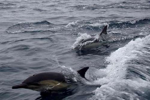
Not too long after that we headed back on the ferry to Ventura for some much needed burritos. On our way back, however, we were treated to an awesome treat: a “mega-pod” of dolphins. The captain estimated that between 1500 to 1800 dolphins were swimming around the ferry. Everywhere you looked and saw a ripple on the water was another dolphin, some leeping out of the water. Even just looking over the side of the boat you could see droves of them swimming under the water with their white skin shimmering through the turquoise of the ocean’s surface. An amazing end to a fantastic trip!
![User Profile Image]() Dolphins in the megapod1
Dolphins in the megapod1![User Profile Image]() Dolphins in the "megapod"
Dolphins in the "megapod"Trail that doesn't exist
The trail highlighted showed up in my GPS software (Topo 8) and on my Channel Islands map from National Geographic. It is SUPPOSED to be right after the split from Chinese Harbor. On our first trip to SC Island we had planned on taking the trail verses the fire road, but couldn't find it. On our second trip, the ranger confirmed the trail was no longer in use. In short, don't bother looking for it!
![User Profile Image]() Trail that doesn't exist
Trail that doesn't exist
Comments
No comments posted yet.