
|
|
Mountain/Rock |
|---|---|
|
|
47.76670°N / 121.1077°W |
|
|
Hiking, Mountaineering |
|
|
Winter |
|
|
5476 ft / 1669 m |
|
|
Overview
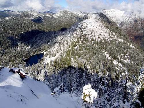
Tye Peak, located just north of Stevens Pass is a lesser known summit in the region despite being within 3 miles from a major ski area and very close to the Pacific Crest Trail. That is because there is no trail to the summit of Tye Peak and it is often a moderate to difficult bushwack to get to during the spring and summer months. Once you get to the lower section of Skyline Ridge you have to descend a very steep slope which is often covered with moss and branches or rock making it very difficult to descend. Because of the difficult bushwack and the modest elevation Tye Peak is rarely done in the summer. It is also a tough traverse from Sky Mountain and requires a number of scramble moves and bushwacking up and down 400 of elevation gain.

Tye Peak and the nearby lake and river was named surveyor W.H. Tye who worked for the Great Northern Railway during 1800's when the railroad was being constructed in Stevens Pass. Many of the features in the area were named Wellington but after the deadly avalanche disaster in 1910 all names associated with Wellington were dropped. I want to thank Redwic for noting this additional information.
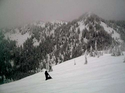
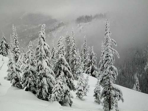
In winter though the snow fills in much of the difficult bushwacking and this mountain becomes easier to attain in winter and early spring. The snow covers the bad moss and the steep slope can be much easier and safer to descend with some nice snow. I personally found a safe spot to glissade roughly 200 feet to more gradual ground. From there just side traverse on a gradual slope all the way to the ridge connect Sky Mountain and Tye Peak. Make right at the ridgeline and ascend Tye Peak. When the snow is firm or windsweep to the west (like the day I climbed) Tye Peak can be done but it will require an ice axe. Play close attention to immediate avalanche danger when trying this mountain though. If the final slope is slab or has received fresh or wet snow use strong caution for possibly avalanche danger here. For more specific information of the route click HERE.

If you are lucky views from Tye Peak can be the same quality of those from nearby summits like Cowboy Mountain and Sky Mountain with both Rainier and Glacier Peak showing up. Other mountains that will show up in view are Baring, Gunn, Union, Jove, Sloan and Nason Ridge. Unfortunately was I not that lucky for views but still got great views of the winter landscape around Stevens Pass.
As for the summiting the other peaks on this ridge or traversing this ridge(Skyline Ridge and Sky Mountain. During summer prepare for intense high angle bushwacking, strong route finding, and some scrambling. Though doable it will be a very long and tough process for three peaks that are modest in elevation. In winter both Tye Peak and Sky Mountain can be combined fairly easily but the true summit scramble of Skyline Ridge will be very difficult and dangerous due to its small summit area and the fact the summit rocks can get very icy in winter.
Getting There
VIA STEVENS PASS: Take Route to Stevens Pass. Stevens Pass is located 20 miles east of Skyomish and 30 miles west of Leavenworth. At Stevens Pass you want to look for the obvious ski area on your south side. Once you hit that ski area you want to pull into the overflow lot on the opposite side of the ski area. When there you will see a snow filled road that will be left of a small grey building. That will be where you start for your trip to the summit. Ignore the Pacific Crest Trail which will be to the right of the same gray building.Red Tape
Provided you park in the ski resort overflow lot on the north side of US 2, there will be no fee.Weather Information
Here is a link to shots of live shots of Stevens Pass.Here is the NOAA forecast for the western Cascades
Redwic - Dec 22, 2010 3:03 pm - Voted 9/10
A Little Local History...Great Northern Railway originally used the name "Wellington" to describe several natural features within this region, but after the 1910 Wellington avalanche disaster occurred nearby the railroad company thought it best to completely drop and replace the local "Wellington" references. Tye Peak, Tye Lake, and Tye River were named for W.H. Tye, a locating engineer (surveyor) who was employed by Great Northern Railway in the 1800s while creating a railroad grade to Stevens Pass.
EastKing - Dec 22, 2010 3:31 pm - Hasn't voted
Re: A Little Local History...Thank you for this information. I have included it onto the page.