
-
 2826 Hits
-
 81.84% Score
-
 14 Votes
|
|
Mountain/Rock |
|---|---|
|
|
38.83190°N / 105.6513°W |
|
|
Park |
|
|
Hiking |
|
|
Spring, Summer, Fall, Winter |
|
|
10090 ft / 3075 m |
|
|
Overview
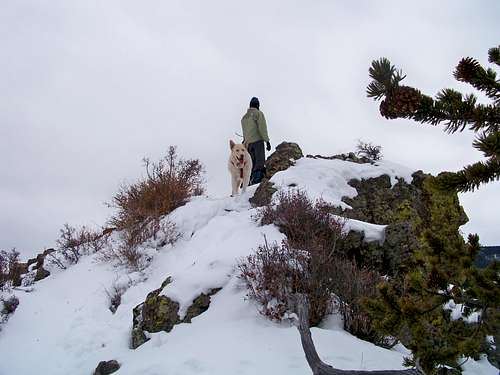 SPer collardr and my dog Lela on the rocky summit
UN 10090 is one of several southern Park County peaks that are easy to reach the summit of, yet almost guarantee solitude. There’s something about a mountain with no name and no trail that seems to keep the crowds to a minimum. While the slopes of this mountain are largely covered in dense evergreen timber, the long, narrow and rocky summit ridge provides fine views in most directions. A rugged, lichen-covered summit block serves as a fine lunch spot and a restful spot to take in the open views.
Rank: 2261st highest peak in Colorado
Prominence: 510 feet
USGS Quad: Dicks Peak
Rank and Prominence Source: Lists of John
Getting There

UN 10090 is west of CO Hwy 9, roughly 15 miles south of the town of Hartsel (which is located at the intersection of CO Hwy 9 and US Hwy 24). The peak is in far southern Park County near Thirtynine Mile Mountain, about 8 miles as the crow flies southwest of Eleven Mile Reservoir.

Hwy 108 Route
Roundtrip Distance: 2 2/3 miles
Elevation Gain: 725 feet
YDS Rating: Class 2
Driving Directions
From Hartsel, Colorado, near the intersection of US Hwy 24 and CO Hwy 9
• Follow CO Hwy 9 south for approximately 15 miles.
• Turn right / southwest on Park County Road 108.
• Park at this intersection (snow season) or proceed southwest on this road for about ½ mile (snow-free)
Red Tape
Very few rules govern your use of this part of the National Forest. There are privately-held ranches nearby, however; be mindful of avoiding private property. There is no fee to use this part of the National Forest and parking is free.Camping
 To the high country beyond
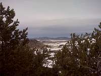 Shrouded summit views
Immediately Surrounding the Peak
This peak is close to roadways and clean, reliable water sources are scarce. Camping right near the peak cannot be recommended.
Eleven Mile State Park
Colorado State Parks operates eight campgrounds near the Eleven Mile Reservoir, as well as 25 backcountry campsites accessible by foot or boat only. Visit this site for detailed information.
US Forest Service Campgrounds
The National Forest Service has a large selection of campgrounds in and around the Lake George area.
| Campground Name | Elevation | Sites | Nightly Rate | Reservations? | Notes |
|---|---|---|---|---|---|
| Blue Mountain | 8,200 ft. | 21 | $12 | Yes | Less than 3 miles as the crow flies from the summit of Blue Mountain. |
| Spruce Grove | 8,600 ft. | 27 | $12 | No | Let the gurgling Tarryall Creek sing you to sleep. |
| Twin Eagles | 8,600 ft. | 9 | $8 | No | Must haul or purify drinking water. |
| Happy Meadows | 7,900 ft. | 8 | $12 | No | Situated along the South Platte River. |
| Round Mountain | 8,500 ft. | 16 | $12 | Yes | Drinking water, vault toilet and trash pickup. |
| Springer Gulch | 8,300 ft. | 15 | $12 | Yes | Situated within the Elevenmile Canyon; water, tables, fire grates. |
| Riverside | 8,000 ft. | 19 | $12 | Yes | Situated within Elevenmile Canyon; large grassy meadow with little shade. |
Weather & Seasons
 Views of the neighborhood
Summer: The route could be a bit hot and dusty in the summer, but the access roads should be dry and accessible and the breezes on top pleasant.
Spring: The snowpack is less deep here than in the high country and melts out faster than higher areas to the west. None-the-less, expect post-holing through unconsolidated snow drifts in the trees.
Fall: The aspen coating the slopes of this peak and surrounding neighbors make this area a golden-hued heaven in the fall.
Winter: Thanks to proximity to both US Hwy 24 Colorado Hwy 9, as well as to “primary dirt roads”, this peak is accessible year-round, barring a major blizzard. The roads in this area are prone to wind-drifting. Be ready, however, to wallow in deep snow on the densely-timbered slopes.