
-
 10930 Hits
-
 73.06% Score
-
 3 Votes
|
|
Mountain/Rock |
|---|---|
|
|
37.90732°N / 105.55906°W |
|
|
Saguache |
|
|
Hiking, Mountaineering |
|
|
Summer |
|
|
13050 ft / 3978 m |
|
|
Overview
Unofficially named Golden Lotus Mountain (also referred to as "Dead Man Peak") is located at the confluence of the Deadman and Pole Creek drainages in a remote portion of the Sangre de Cristo mountains northeast of the Great Sand Dunes. This 13,050' summit lies at the southern end of a very aesthetic ridge whitch rises between East and West Deadman Lakes. The connecting ridges which run from Golden Lotus Mountain to UN 12,729', 13,200' "Deadman Mesa," 13,384' "Deadman Peak," 13,414' Cleveland Peak, UN 13,401', UN 13,495', UN 13,450', and 13,604' Tijeras Peak form a dramatic complex of glacially carved terrain.
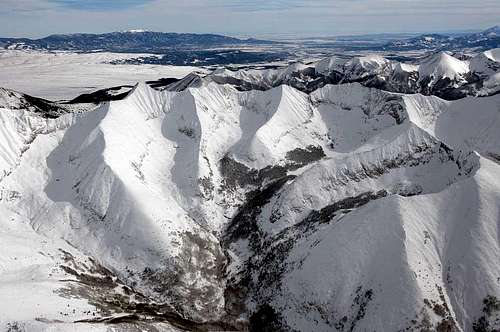 Golden Lotus Mountain is the summit at center right, with steep exposed rock below.
Due to its remote location and poor access, Golden Lotus Peak and its neighbors are blessed with relative obscurity. The logical access point is low in the San Luis Valley, in the middle of the Luis Maria Baca Grant No. 4. This large section of land on the east side of the SLV was made private back in the 1800's and access to this portion of the Sangres has been an issue for decades. With the recent formation of the Great Sand Dunes National Park and Preserve, access is once again public, but still not easy--Deadman Creek and Pole Creek drainages, which both lead up to the Deadman complex, offer the prospect of a long, deadfall-choked bushwhack. From the Deadman basin there appears to be a straightfoward class 2 route to the summit of Golden Lotus Mountain. Alternately, one can access this group from Music Pass and Sand Creek Lakes.
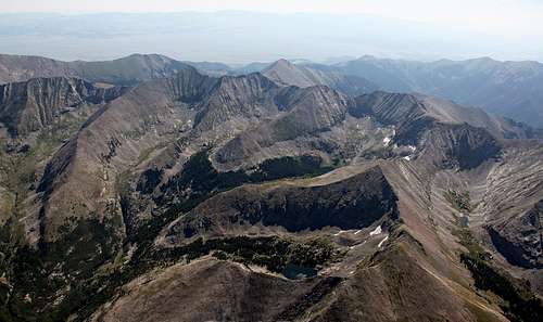 Aerial photograph of Deadman Lakes, with Golden Lotus Mountain at center right.
I can find no information on the origin of the name "Golden Lotus Mountain." It appears on Kent Schulte's "Sky Terrain" trail map of the Sangre de Cristos, but not on the USGS quad. More detailed (first hand) information coming soon.
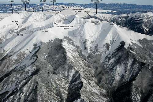 Aerial view looking northeast in winter.
Getting There
Deadman Creek and Pole Creek are accessed from San Luis Valley. Park in the Baca Grande subdivision near Crestone, at the southern end of Camino Baca Grande road. Park at the gate and hike Liberty Road to the terminus of Deadman Creek or Pole Creek to the south. The USGS quad shows a trail up the Deadman Valley, but it could be overgrown and nonexistent by now. Expect extreme temps, lots of insects, creek crossings, and bushwhacking through thick patches of gambel oak, pinyon, juniper, aspen, spruce, fir, and willows as you ascend.