
|
|
Mountain/Rock |
|---|---|
|
|
45.46490°N / 116.3924°W |
|
|
Idaho |
|
|
Hiking, Scrambling |
|
|
Summer, Fall |
|
|
5230 ft / 1594 m |
|
|
Overview
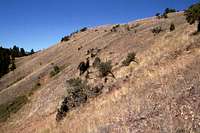
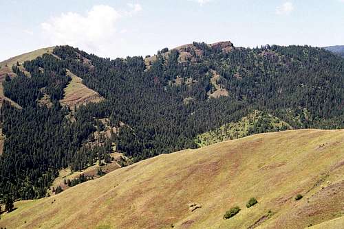 The north side of the ridge

This mountain is one of many points in the Salmon River Canyon that while not high in elevation compared to the neighboring Seven Devils or Salmon River Mountains, are prominently separated and have a significant vertical rise above the canyon bottoms. Some of these summits offer a wide variety of experiences ranging from easy hikes, to difficult scrambles to technical rock.
This ridge dividing the Race and Kessler basins has 410 feet of prominence and rises 3,520 feet above the Salmon River to the east. Reaching the summit is fairly involved and requires close instructions because access to the lower points of the mountain is denied by a private land owner. Thus the only legal access is from the top near the main Salmon/Snake divide; making this mountain unusual because one must actually descend for a few miles before climbing the summit. Overall, it’s a fairly unexciting mountain, but there are still some interesting things to see here.
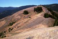
The south side of the mountain is dominated by Canyon Grassland habitats and open Ponderosa pine forests. An interesting vegetative component is a community of stiff sage brush on the southeast flank of the summit. This thin soiled, rocky area provides unusual habitat supporting flora that is rare in this region. The north side of the mountain is covered with a much moister and dense grand fir and Douglas fir forest. The mountain is remote with only one old logging road accessing the saddle to the west of the summit from private land below, but this cannon be legally used. The area supports a large mule deer and winter elk population, but these must share their habitat with livestock so watch your step. There is no grazing allotment on the Forest Service ground that includes the summit, but illegal trespass grazing from the private land below is common.
These canyon grasslands are important ecologically for big game winter range and unusual vegetative communities, which have been largely displaced by invasive weeds, especially below approximately 5,000 feet in elevation. Several endemic and rare plant species can be found in this area, but very little of the native grassland habitat remains. The open Ponderosa pine/savanna vegetative communities that also occur here are greatly reduced due to decades of fire suppression that eliminated the natural disturbance necessary to maintain them. As a result tree density is much greater in some areas than normal and some areas of grassland are converting to forests. The natural species composition has also been changed. The local Forest Service unit has plans to implement controlled prescribed fires to reduce the unnatural fuels accumulation, restore natural forest community structure and return to a more historic fire regime interval. Unfortunately the implementation of this sound, common sense management is facing a stiff challenge from uninformed, but powerful environmental groups.
Due to the local arid climate and the open south facing slopes, this mountain can get very hot during the summer (often 100 degrees or more) so take care to bring plenty of water and be prepared for high temperatures and solar exposure.
Getting There

From the town of Riggins, head north on Highway 95 for approximately one half mile then turn west onto the Race Creek Road (Forest Service road 241). Continue up this road for approximately 14 miles to Iron Phone Junction on the main divide between the Snake and Salmon canyons. There is a nice dispersed campsite here. Turn south on the 420 road and continue for about 5 miles to a relatively flat ridge top where another unmarked but obvious dispersed campsite can be found. The road leading up to this point is eroding severely and may not be on the mountain side much longer. It is generally not free of snow until early to mid June. An alternative route, road 240 leaves the 241 road at Bean Creek Saddle (about 6 miles up 241) and connects with the 420 road about 2 ½ mile south of Iron Phone Junction. This will cut a couple miles off the drive, but the 240 road is not always open.
Park at this dispersed campsite and follow the trail east to near the small summit point of Round Knob. The trail is not marked well, but the departure from the road and dispersed campsite is obvious. Near Round Knob, the trail turns southward and descends through beautiful mountain grasslands that break up the mixed coniferous forest. After approximately one mile the trail enters an old clearcut that is full of regenerating trees and dense brush. Continue on the trail to where it ends on an old logging road. Turn left (east) and follow this zigzagging road through the logging unit and the forest below to Pipe Saddle. Overall this hike descends approximately 1,700 feet over nearly four miles. USGS maps show this trail, but it passes much closer to Round Knob than indicated and meets the 420 road on the saddle just west of Round Knob. Road 420 is not on the USGS quads, but the standard Nez Perce National Forest map shows it. From Pipe Saddle, one is finally ready to start the hike to the summit.
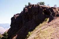
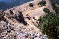
From Pipe Saddle, hike east up the steep ridgeline through dense forest before reaching a large grassland on the south aspect. Continue on the ridge top for a short distance to the steep, but short scramble of the high point pyramid. The second high ridge point to the east is slightly lower and requires descending over 400 feet then ascending nearly 300 feet on a more rocky scramble to reach the top, but the views of the lower canyons are better. After reaching the high point goal, its time to turn around and descend to Pipe Saddle before the long and monotonous 1,700 foot hike up to the trailhead.
A much more challenging hike would be from the bottoms of the Race or Kessler drainages, but one would have to cross ground that is specifically forbidden by the landowner before the steep, rocky and hot climb.
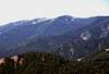
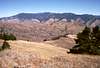
Views From the Top
Though the mountain is not real high, it is surrounded by much higher mountains and very deep canyons. Thus the views in most directions are spectacular. Here are a few.
 |
 |
 |
 |
Red Tape
None.Camping
There are no developed or designated campgrounds nearby, but there is the dispersed camp at the trailhead. Another potential spot is Iron Phone Junction at the junction of roads 420 and 241. Lodging is also available in Riggins and there are some dispersed camp sites along the Salmon River off Highway 95.When To Climb
This summit area is generally free of snow from late spring until late October or early November. However, the higher country where the hike starts can be blocked by snow until well into June. Check at the Forest Service office below to enquire about access before you go.Mountain Conditions and Additional Information
Contact the Salmon River Ranger District of the Nez Perce National Forest for local information and current conditions.Salmon River Ranger District
Slate Creek Ranger Station
HC 01, Box 70
Whitebird, ID 83554
(208)839-2211
FAX:(208)839-2730
NOAA Forcast