
-
 2682 Hits
-
 79.04% Score
-
 10 Votes
|
|
Mountain/Rock |
|---|---|
|
|
38.84210°N / 105.6323°W |
|
|
Park |
|
|
Hiking |
|
|
Spring, Summer, Fall, Winter |
|
|
9900 ft / 3018 m |
|
|
Overview
 Rocky summit area
This twin-cone-shaped peak rises abruptly out of the surrounding high prairie of southern Park County. This is a neat, petite, double-humped peak capped by rocky summit boulders made of red volcanic conglomerate, remnants of the ancient, giant Guffey Volcano. The peak is easily accessible and can be visited in all seasons. From the summit, the visitor can enjoy views of the nearby ranching country and soft, rounded hills as well as high country to 14,000 feet and beyond in the distance to the west and north.
Rank: 2,372nd highest peak in Colorado
Prominence: 320 feet
USGS Quad: Dicks Peak
Rank and Prominence Information Source: Lists of John
Getting There

UN 9900 is east of CO Hwy 9, roughly 15 miles south of the town of Hartsel (which is located at the intersection of CO Hwy 9 and US Hwy 24). The peak is in far southern Park County near Thirtynine Mile Mountain, about 8 miles as the crow flies southwest of Eleven Mile Reservoir.
Red Tape
 Threemile Mountain from the summit
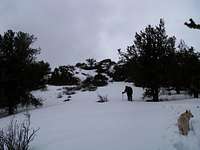 Breaking trail toward summit area
Very few rules govern your use of this part of the National Forest. There are privately-held ranches nearby, however; be mindful of avoiding private property. There is no fee to use this part of the National Forest and parking is free.
Camping
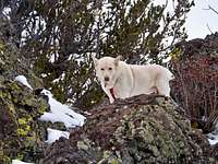 Lela among the summit area rocks
 Northwest from the summit ridge
Immediately Surrounding the Peak
This peak is close to roadways and clean, reliable water sources are scarce. Camping right near the peak cannot be recommended.
US Forest Service Campgrounds
The National Forest Service has a large selection of campgrounds in and around the Lake George area.
| Campground Name | Elevation | Sites | Nightly Rate | Reservations? | Notes |
|---|---|---|---|---|---|
| Blue Mountain | 8,200 ft. | 21 | $12 | Yes | Less than 3 miles as the crow flies from the summit of Blue Mountain. |
| Spruce Grove | 8,600 ft. | 27 | $12 | No | Let the gurgling Tarryall Creek sing you to sleep. |
| Twin Eagles | 8,600 ft. | 9 | $8 | No | Must haul or purify drinking water. |
| Happy Meadows | 7,900 ft. | 8 | $12 | No | Situated along the South Platte River. |
| Round Mountain | 8,500 ft. | 16 | $12 | Yes | Drinking water, vault toilet and trash pickup. |
| Springer Gulch | 8,300 ft. | 15 | $12 | Yes | Situated within the Elevenmile Canyon; water, tables, fire grates. |
| Riverside | 8,000 ft. | 19 | $12 | Yes | Situated within Elevenmile Canyon; large grassy meadow with little shade. |
Eleven Mile State Park
Colorado State Parks operates eight campgrounds near the Eleven Mile Reservoir, as well as 25 backcountry campsites accessible by foot or boat only. Visit this site for detailed information.
Weather & Seasons
Summer: The route can be a bit hot and dusty in the summer, but the road should be dry and accessible and the breezes on top pleasant.
Spring: The snowpack is less deep here than in the high country and melts out faster than higher areas to the west. None-the-less, expect post-holing through unconsolidated snow drifts in the trees.
Fall: The aspen coating the slopes of this peak and surrounding neighbors make this area a golden-hued heaven in the fall.
Winter: Thanks to proximity to both US Hwy 24 Colorado Hwy 9, as well as to “primary dirt roads”, this peak is accessible year-round, barring a major blizzard (the roads in this area are prone to wind-drifting). Expect some deep snow wallowing where the trees are thick during a winter ascent.