
-
 14550 Hits
-
 79.04% Score
-
 10 Votes
|
|
Mountain/Rock |
|---|---|
|
|
34.0045°S / 19.02100°E |
|
|
5213 ft / 1589 m |
|
|
Overview
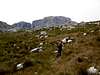
Victoria Peak is the second highest peak in the Boland mountains, only 1m short of the highest, Somerset Sneeukop. Due to its central position in the range, it is a particularly rewarding climb, offering stunning unobstructed views in absolutely all directions.The Boland mountains lie just outside Cape Town, to the east, and present a wall of mountains which appear to bar the way out of Cape Town to the rest of South Africa. Despite the fact that the altitude of these peaks is rather modest (1300 - 1600m), they are very impressive as they rise up above the Cape Flats, which are not much higher than sea level. These mountains are also extremely rugged, and particularly around the Jonkershoek valley you can twist your neck backwards and stare up at the imposing towers of grey rock above you. Victoria Peak itself is however not a difficult climb, as there is a good path running just about all the way to the summit. Its cliffs are on the other side of the peak, hidden from view when you take this path, so the mountain seems a little more benign than its lower neighbours.
The peak itself is not especially impressive, so many of the pics I've posted are of what you can expect to see from it and approaching it, which is the real attraction to the place.
 |  |  |  |
Getting There
The most common way to approach Victoria Peak is from the Jonkershoek "Panarama Trail". This is a 14km circuit of the upper Jonkershoek valley, and from the top of the trail, roughly half way round the skyline, you can take a branching path which leads to Victoria Peak. Getting to the Peak involves a 3km trek across the marshy plains to the foot of the peak, and then a fairly direct, but not terribly steep path up the last 350m of ascent to the summit. The start of the trail, in the valley, is at about 380m above sea level, you then ascend up to the left along a long, gently rising path to the nek (col) above Assegaisboschkloof, at roughly 1000m altitude. Most of the ascent will have morning shade. From here you have remarkable views into the kloof (river valley), and more impressively, the Assegaisbosch ridge peaks rising up just to north west of where you stand. These peaks are extremely rugged, having large cliffs and numerous small pinnacles attached to them. After admiring the view, you should look for the path leading you away from the nek, ascending wide grassy bands through the broken ground to your right. Eventually you come out into a hilly area where the path contours around and through stream beds. You will soon notice a path branching to your left. This first path does not lead to Victoria Peak, it curves to the left and away from the peak. At this point there are cairns marking a route to Victoria, but you should really have stayed on the main trail and waited for the next path branch to the left, roughly 800m along the Panarama Trail from where the first path branched. This second path will take you directly to Victoria Peak. After crossing the plains to to the peak, simply follow the path up the southwestern slopes to the summit. Near the top the path becomes faint, but there are cairns to help you out. The only way to hit trouble here is when visibility is poor and you miss the path across the plains. Once you are back on the Panarama trail, head left and contour for a while (on the path) until the trail descends to the top of a ravine where the path branches right, down the ravine. Follow this ravine path back into the Jonkershoek valley and back past a couple of waterfalls to where you started. This is the Kurktrekker path. You can of course do this all the other way round, ie anticlockwise circuit. In fact, the quickest way to tag the peak is to use Kurktrekker both ways.In order to get to the Jonkershoek valley, drive out of Cape Town to the town of Stellenbosch, about 50km away, and drive through Stellenbosch along Merriman Street towards the moutains. Go straight on at the two traffic circles and follow this road out of town past pastures and vineyards until the tar road ends at the gate of the reserve.
 |  |  |
Red Tape
There are two fees to pay at the gate. First, you must pay to take your car onto the forestry access road (about R10 or R20 - $1 or $2), second you must pay Cape Nature for a permit to hike the trail (about R20pp). A Wildcard will cover the trail fee and a year permit for use of the forestry roads can be purchased for R200.You then drive up into the reserve on a rough one-way gravel road to a bridge (Witbrug) where it turns round and to go back out of the valley (the road is rough, but with careful and alert driving it is passable for an average sedan). Park here and look around for the start of the paths, either side of the bridge. Be very alert when driving here as the corners are blind and this is a very popular mountain biking area.
When To Climb
The peak can be climbed all year round, however if you plan to do the Boland trail (a multi-day circuit of the Boland range), this is closed in winter due to the very bleak weather often experienced here in in that season. In mid summer it can get hot, and in winter snow can often be found. It is still possible to climb the peak without specific snow gear even when the snow is deep. However, snowmelt turns the path across the plains into a stream for much of the way.Camping
You don't need to camp to climb this peak, but if you want to take a few days out you could do the Boland Trail. There are huts on this trail, notably Landdroskop hut, which is in a good position if you want to bag the other high-ish Boland peaks, such as Somerset Sneeukop, 1590m and the Triplets, 1516m. There is a separate trail fee and hut fee if you chose to do this. Contact Cape Nature Conservation for details.Mountain Conditions
There is often snow in winter, and it can be fairly thick by South African standards. There are a number of reliable streams on the route. On the north side you will cross a couple of streams about halfway along the ascent to Assegaaisboschkloof Nek, and on the south side you will find a stream which springs up in the indigenous forest about halfway up Kurktrekker, as well as the waterfall streams lower down on that route. On the high part of the Panorama Trail, there are smaller and less reliable streams.Take warm clothes with you regardless of what time of year you climb. Even in summer the weather can turn bad and on seemingly calm days the wind on the summits can be extremely penetrating.
Take a camera, you'll find plenty of views to photograph.
For a weather update, go to www.weathersa.co.za