
-
 17141 Hits
-
 79.04% Score
-
 10 Votes
|
|
Mountain/Rock |
|---|---|
|
|
44.86500°N / 122.2079°W |
|
|
4969 ft / 1515 m |
|
|
Overview
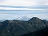
Whetstone Mountain, part of the older West Cascades, is located in the Bull of the Woods Wilderness about 45 miles east of Salem. The Bull of the Woods Wilderness and the neighboring Opal Creek Wilderness is the largest contiguous area of low elevation old growth left in Oregon. The summit is a former lookout site with great views stretching from Mt. Adams to the Three Sisters and across the Willamette Valley to Mary’s Peak, the highest point in the coast range. Mt. Jefferson, only 25 miles away to east, takes center stage.
The peaks of the older Western Cascades have gone through vast cycles of eruption and erosion from 37 million years ago up until 7.4 million years ago, when the center of volcanic activity shifted east and began forming the larger more well known volcanoes, such as Jefferson, Hood, and the Sisters. These peaks were once much larger, but have been worn away by millions of years of water and glacial erosion at the higher elevations. The result of this erosion has left us with the heavily forested round ridges that characterize the Western Cascades today.
While not a technical, or particularly challenging climb, the old growth forest and view from the small summit area make this a well worthwhile hike. The trail gains just over 3,000 ft. (3,450 total with loss and gain) in about 5 miles. Noble and Pacific Silver Firs dominate the summit ridge with thick Rhododendrons in bloom from June to early July.
 |  |  |  |  |
Getting There
From Salem, OR in the west, take North Santiam Highway 22 (follow the sign that says to Detroit Lake) for 23 miles to the town of Mehama and the second flashing yellow light at the Swiss Village Restaurant. Take a left here onto Little North Fork Road and go 14.8 miles on the paved road until it changes to gravel. Continue straight on this road until it ends at the gated Opal Creek parking area. Park at the locked gate and continue up the road a quarter mile past the Gold Creek Bridge. On your left (north) take trail 3369 that climbs up an old road towards Whetstone Mountain.
Whetstone Mountain may also be accessed from the north via trail #546. To get there from Estacada take highway 224 26 miles to the bridge at Ribblebrook. Keep straight on paved road 46 for 3.6 miles, and turn right onto paved road 63 for 3.5 miles, and turn right onto paved road 70. Drive 9 miles and turn left onto road 7030 for 5.6 miles. Turn right onto road 7020, and follow it 0.7 miles to spur road 028 which has a sign for Whetstone Mountain Trail #546. Follow this to the parking area.
 |
Red Tape
To park at the trailhead you will need a NW Forest Pass. Passes are available at the trailhead. You will also need to fill out a free self-issued wilderness pass at the trailhead.
When To Climb
Whetstone can be climbed year round, but there will be plenty of snow in the upper portions in the winter, so be prepared. The best time to climb is June through October. June and early July is the best time to see the Rhododendrons in bloom.
Camping
Camping is allowed in both the Bull of the Woods and Opal Creek Wilderness. There are several places you can pull off on the road in where you can camp. There are very few places on the trail to camp, only a few very small uneven areas. There is no water along the trail. The terrain in both wilderness areas is very rugged and can be difficult to find campsites.
Mountain Conditions
Detroit Ranger District
HC73, Box 320
Mill City, OR 97360
(503) 854-3366
fax (503) 854-4239