
|
|
Route |
|---|---|
|
|
38.23400°N / 119.656°W |
|
|
Hike / Scramble |
|
|
Class II with some Class III |
|
|
Approach
Molo Mountain is located in the western region of the Emigrant Wilderness Area. The closest trailhead is the Kennedy Meadows trailhead, located off of CA Highway 108, just west of the Sonora Pass. Directions are available on the Kennedy Meadows Resort web site.Click here for USGS Mapping Information.
The easiest route to the summit is from the east, from Lost Lake. Lost Lake is one of the headwaters of the Cherry Creek drainage and can serve as an ideal base camp for climbing Molo Mtn. The shortest route (12 miles) to Lost Lake is to hike past Kennedy Lake on-trail and then follow the outlet stream of Lost Lake up all the way. However, be warned that this is a grueling off-trial climb from 7800' to 9600' with long stretches of rock scree and patches of steep snow fields to cross.
The easier, but longer route (15 miles) to Lost Lake is to follow the Huckleberry Trail past Relief Reservoir, then take the trail split to Brown Bear Pass. On the east side of Brown Bear Pass you'll see Cherry Creek coming from Lost Lake to the north. From here, it's an easy 1.5 mile hike through grassy meadows to reach the lake.
 |
Route Description
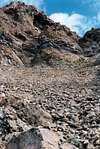
The ascent starts from Lost Lake, which sits at an elevation of 9,650'. Follow the outlet stream from Lost Lake 200 feet to the south, towards Emigrant Meadow Lake. There is a false ridge and meadow that sits above Lost Lake that can be easily gained from just about anywhere south of the lake. This is an easy class II climb up about 450 feet.Once you reach the meadow, the East Face of Molo Mtn will be right before you. Ascend straight up the rock scree in the center of the East Face, keeping just to the right of the first large buttress. There is a small gap and then a second buttress above the first. Hug the right side of that one also. Next, there will be a line of volcanic rock that laterals across your path, sticking up a couple of feet from the rock scree. This is a nice place to sit and catch your breath.
Continue up the rock scree until you reach a third, pretty high buttress that blocks your path. Traverse to the left of the butress and squeeze between it and another rock wall on the left side. There is a bit of fairly easy class III climbing required to make your way up and between the 2 volcanic rock croppings. The summit is just a few more steps after that.
Once on the summit, you'll see Kennedy Peak to the north, Big Sam and Lost Lake to the east, Tower Peak and Saurian Crest to the southeast, Grizzly Peak and Emigrant Meadow Lake to the south, the volcanic nipple and Relief Peak to the west, and Soda Canyon to the northwest. Enjoy the views!
 |  |