
|
|
Route |
|---|---|
|
|
39.76790°N / 106.3854°W |
|
|
Hike |
|
|
A long day |
|
|
Class 1-2 |
|
|
Approach
Follow Highway 9 north of Silverthorne or south of Kremmling, to County Road 10-Spring Creek Road which branches to the west of Highway 9 between mile post 128 and 129. (This is 2.5 miles north of Green Mountain Reservoir). Follow the gravel road (County Road 10) west turning right after a short distance at a "public access" sign. Go straight at the intersection at 6.3 miles from the highway. After another 1.1 miles, turn right at the road posted for "Sheephorn Drive" and "Mahan Lake". Stay on the main track until you reach an interesection 10.4 miles from the highway (3 miles from the Sheephorn Drive sign). Stay left following the road posted for Mahan Lake. In another 1.6 miles, turn right at the fork. After another mile turn left and follow the short track to Blue Lake. This is the trailhead. The road to the trailhead is pretty rough for passenger cars.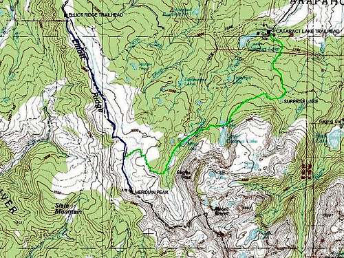 Overview Map-The Elliot Ridge Route is the one in blue.
Route Description
From the trailhead at Blue Lake, follow the trail, which is an old blocked off 4wd road, aloong the west side of Elliot Ridge. The trail gains elevation at a rather gentle grade up to the timberline after a short distance. There is a marshy meadow after 0.9 miles and the trail is marked with post and cairns above the timberline.Great views in all directions open up along the ridge and the trail reaches a minor saddle before climbing up to a highpoint along the ridge. The trail continues along the ridge to near another highpoint at 11,952 feet. Since the peak is a "ranked 11'er", peak baggers may want to take the short side trip to point 11,952, which is 3.8 miles from teh trailhead.
Beyond the point, the trail descends to a saddle at 11,650 feet before climbing along the gentle ridge to the junction with the Upper Cataract Trail after 4.9 miles from the trailhead and at 11,955 feet. Meridian Peak is another 1.2 miles south of the junction (straight) along the Elliot Ridge Trail, and is a total of 6.1 miles from the trailhead.
The views from the summit of Merdian Peak are very spectacular. Mount Powell and Eagles Nest Peak are the highest peaks just to the south. The other jagged peaks to the south are un-named. There are countless valleys and mountain ranges visible from the summit. If you know where to look, you can see all the way to Longs Peak. The Flat Tops, Mt. Sopris, and other peaks in the Aspen area are visible as is most of the Park Range and Rabbit Ears Range. South of Meridian Peak the character of the ridge changes from gentle to very rugged and some serious scrambling is required to follow the ridge farther.
 Looking along the Elliot Ridge on the way to Meridian Peak. Eagles Nest is the big peak in the background.