
|
|
Route |
|---|---|
|
|
40.36360°N / 109.131°W |
|
|
Difficult scramble with technical pitch |
|
|
Most of a day |
|
|
Class 5.2-5.4 |
|
|
Approach
You must have a good map to find the trailhead. Directions are breif. Drive along Highway 40 from either Vernal and Jensen on the west or Dinosaur Colorado on the east. County Road 16 takes off from the north of Highway 40 about four miles west of the Colorado/Utah state line. There are actually two roads that take off Highway 40, to make CR 16 and they both meet after a short distance at a junction. Drive north on the county road (marked for Echo Park) until it makes a curve from north to east. This is after following the road for just under three miles from the junction. Turn left on a lesser used road that is maked on the topo. After a short distance turn right and stay on the northern bearing road that heads to the base of Blue Mountain. There are many turn-offs, so follow the map carefully and head towards the mountain. Park where the road crosses the wash that drains Blue Mountain for the second time. This is about 1.6 miles from CR 16. CR 16 is good for all cars, and the other road mentioned is for 4wd's only.
 |  |  |
Route Description
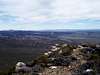
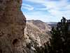
Make sure to observe the route on the drive in. Notice the radio towers visible. The route you want starts from the canyon two canyons east of the radio towers. The correct ridge is on the west side of the canyon and at the "6500" number marking the contour line on the Snake John Reef Quad. From the car-park, follow the drainage up towards the mountain for .6 miles to near the mouth of the canyon. Climb up to the ridge bypassing the rock fins on the south side. Gain the top of the ridge above the rock fins. This ridge will be followed all the way to the summit plateau. There is much steep scrambling and bypasses around rock fins. This ridge would be a fairly straight forward class 3-4 scrambling route if it wern't for the crux pitch through the cliff band. This is about 4/5's of the way to the summit. This pitch can be dangerous and I recommend starting the climb early in the morning and thus to have enough time to look for a bypass around the crux. I estimate the crux pitch to be 5.2 to 5.4 in difficulty. It isn't that difficult to climb, but is highly exposed and hard to protect. It scared the heck out me alone and without a rope, and I wouldn't do it un-roped again. I also got scraped up after kicking a rock loose (see trip report). The chute to the west of the crux pitch is another possible route, and I used it for my descent, but it too is no piece of cake either and was filled with waist deep snow overlaying ice. At one point I had to slide off a boulder. I don't know how the bypass is when not snow-covered, but is steep and may be filled with loose rock (If you climb the route snow free, please post an addition/correction). From below, it appeared that the crux pitch may be possible to bypass by contouring along the cliff band to the right, but this is unknown. If you do decide to do the crux pitch, take the time to scout it out, and don't be afraid to turn back if you find it too difficult or dangerous. Once above the cliff-band, the rest of the route steep, but straight forward. After reaching the summit plateau, you may be surprised to find just how flat the summit is. This is a huge contrast to the steep south face. There are rolling meadows, aspen, and pine forest. Consider walking to various viewpoints. The true summit is slightly higher and to the west where the radio towers are located, but the views aren't as good from there. From the mouth of the canyon, the route is only .6 miles, and with 1700 feet elevation gain, but is very time consuming.
I have decribed what I believe is the best route, and was more-or less my descent route. The route I took up for the ascent was actually longer and more difficult. I started from point 5844 because I didn't know the road went that far (I spotted the road from above!). Because I was without any route beta, I also climbed the slabs to the west of the canyon to gain the ridge, and this was more challenging and time consuming. With all the wandering and route-finding, it took 7.5 hours, but since the route description lines out most of the best route, you should be able to climb the route much, much faster, by following the instructions above. If you can find a route around the crux pitch the rest of the route above is pretty reasonable.
 |  |  |  |  |
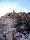
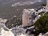
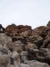
Crux Pitch
Make sure to review all photos attached to this section very carefully before attempting the route! They may prove useful.
 |  |  |  |  |
Essential Gear
Topo map, compass or GPS are necessary. A 100' (30m) climbing rope, rock protection (various cams, slings, friends, nuts; also, for emergency use only, throw in a few baby angles and Lost Arrows), a helmet, and a harness should be taken. You surely won't need all this stuff, but consider taking it just in case you do. The crux pitch looks to be tough to protect and isn't the best quality of rock. It would be better if you could find a bypass around the crux.