
-
 27487 Hits
-
 84.54% Score
-
 19 Votes
|
|
Mountain/Rock |
|---|---|
|
|
49.47747°N / 125.63766°W |
|
|
Mountaineering |
|
|
5833 ft / 1778 m |
|
|
Overview
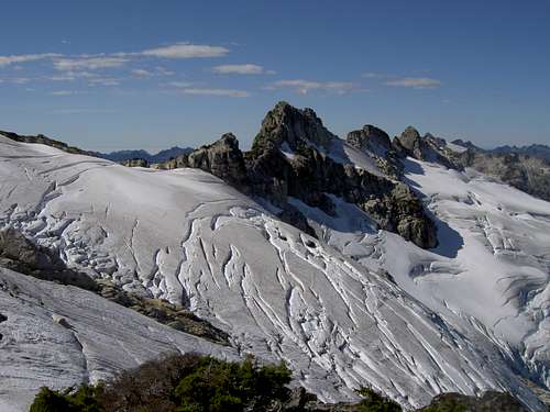 Mt Tom Taylor summit tower and east ridge from the northeast Mt Tom Taylor summit tower and east ridge from the northeast |
Tom Taylor was minister of Public Works in the BC Government from 1912 and was instrumental in securing government funds for the survey and construction of roads and in the development of Strathcona Park.
Getting There/Approach
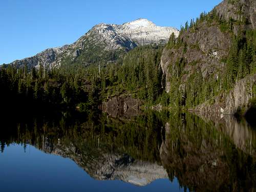
Tom Taylor from Baby Bedwell Lake
Vancouver Island can be reached by air from Vancouver to Victoria, Nanaimo or Campbell River and by ferry from Port Angeles to Victoria on The Coho and on BC Ferries from Vancouver to Victoria or Nanaimo. Public transport on the Island is relatively poor and anyone arriving by air would be advised to rent a car. Access in this case is fine by 2WD only. From Campbell River, at the end of the Island Highway 19, take highway 28 west towards Gold River. After approximately 30km the road meets Upper Campbell Lake with the first views over the mountains and after 47km you will enter Strathcona Park at Elk Portal. Stop and admire the large wooden elk statue. Exactly 1km further on highway 28 makes a right over the bridge at Buttle Narrows. Ignore the turn and carry straight on down the paved Buttle Lake Parkway. This runs south down the east shore the whole length of the lake and offers ever improving views. After 30km the road swings west over a bridge around the end of Buttle Lake. Immediately after crossing the bridge, turn left (south) onto the gravelled Jim Mitchell Lake Road. This road runs up the Thelwood Valley 7km to a parking lot and the trailhead for the Bedwell Lake Trail. Bears often hang around this very popular area, so be sure to leave nothing that might tempt them to enter your vehicle by force!
Complete the formalities, walk 200m further up the road and take the obvious trail on your left. “Pride of BC Parks" on Vancouver Island, the Bedwell Lake Trail is an engineered marvel that puts you into the alpine in a mellow 2-3 hours. This is the easiest approach to the alpine on the Island that doesn’t involve driving. Hike the trail to the obvious pass, up and over the steel ladders, and across the flats to the junction of the main trail with that for the campground at Baby Bedwell Lake. Your objective now lies before you, towering above and, if the winds are calm, exquisitely mirrored in the lake. Be aware, however, that this is not the summit you’re looking at. This lies out of sight, higher and to the west.
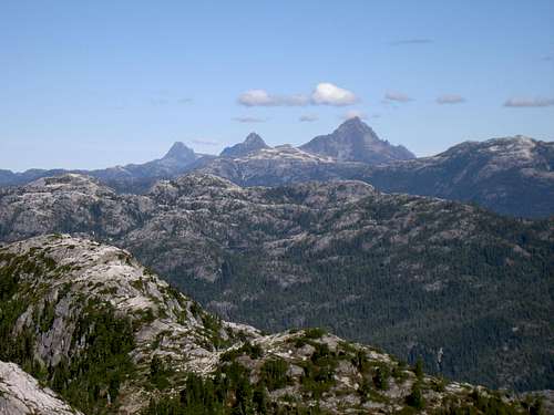
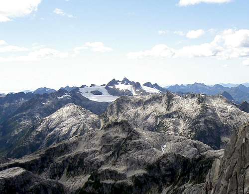
 Mt Tom Taylor, middle distance left. Drinkwater Pass right foreground. Taken from Mt Septimus |
Summary of Summit Routes
East Ridge; 100 metres, low 5th ClassNorth Face; 150 metres, AI2, low 5th Class
South Face; currently 3 routes, 300-350 metres of fine Island granite, 5.9-5.10
Refer to the Island Alpine guidebook – see “Suggested Reading” below.
Red Tape
If you are a day-tripper, there is nothing to pay. If camping at Baby Bedwell, or anywhere else in the designated core area of Strathcona Park, there is a $5/person/day fee. There is a self-registration box and payment slot at every core designated trailhead. Payment can be by cash or cheque. I haven’t seen a stipulation specifying Canadian funds but I’m sure Parks wouldn’t refuse a cheque in US funds.Camping

In this and all core areas of Strathcona Park you must camp only in the designated areas. In the present example this means at Baby Bedwell Lake. Here you will find a dozen or so wooden platforms, some big enough for 2 tents. If none are available choose a site on the dirt that will cause as little impact as possible. If there is still nowhere to put a tent, there are 15 or so tent platforms at the south end of the larger Bedwell Lake an hour further on down the main trail. Fires are strictly prohibited, so you must pack a stove. Both camping areas have a pit toilet and bear-proof food cache. Giardia is well documented throughout Strathcona Park, so boil or treat all water.
External Links
Useful links:Strathcona Provincial Park
Sketch map of Bedwell Trail area
Additional Information/Suggested Reading
Beyond Nootka – A Historical Perspective of Vancouver Island Mountains, Lindsay Elms, Misthorn Press, 1996, ISBN 0-919537-29-4 and/or visit Beyond NootkaIsland Alpine – A Guide to The Mountains of Strathcona Park and Vancouver Island, Philip Stone, Wild Isle Publications, 2003, ISBN 0-9680766-5-3 and/or visit Island Alpine Climbing Guide
View west from the summit of Tom Taylor to Mariner Mountain