
|
|
Route |
|---|---|
|
|
44.27258°N / 118.69905°W |
|
|
Hiking |
|
|
Summer, Fall |
|
|
Half a day |
|
|
not difficult |
|
|
Roads End
Referred to as Road's End by locals, this trail up Strawberry Mountain's long south ridge is the quickest route to the summit of this Grant County Highpoint. Largely burned out by Forest Fires the last decade, this is a dry sometimes dusty hike with a mere 1300 feet of elevation gain over the course of three miles. The first half of the hike is relatively flat, and skirts northward along a ridgeline that extends south from the summit cone of Strawberry Mountain. To the west is Wildcat Basin, to the east just over the ridgeline is the Strawberry Lake Basin.The trail is mostly level until you reach the southern face of Strawberry Mountain's summit cone, where only a little more than a mile of hiking is left to reach the top. At the base of this cone you will meet up with the Strawberry Basin trail as it climbs out of the valley to the east. Shortly before the summit you will also encounter Onion Creek trail, a third possible route to the summit of Strawberry Mountain. This trail is well maintained and offers a leisurely hike with minimal difficulty. Once you reach the north face of Strawberry the hike up the cone is a series of steep switchbacks through loose rock, although the trail is wide and easy to walk.
As an alternative you may consider going straight up the south face of Strawberry Mountain rather than around the east face and up the north side of the mountain. The south face has a faint scramblers path and the difficulty is no greater than class 4 at worse. This will shave maybe 15 to 30 minutes off the ascent time and adds a little adventure to the summit experience.
Below: Looking west you can see the devastation caused by wildfires to Indian Creek Butte's north face on the basins west side.
Getting To Roads End Trailhead
From John Day travel 9 miles south on Highway 395 to paved County Road 65 on the left. Follow this road approximately 15 miles to its intersection with Malheur National Forest Roads 15 and 16. Take a left heading east towards Logan Valley traveling only 2 miles where you will take a left on USFS road 1640. Follow this road 10.5 miles to the Strawberry Mountain trailhead. This trailhead lays on the southwest face of Indian Spring Butte less than half a mile from the High Lake Trailhead. With this routes proximity to Indian Spring Butte, you can easily summit Strawberry and Indian Spring in half a day of hiking.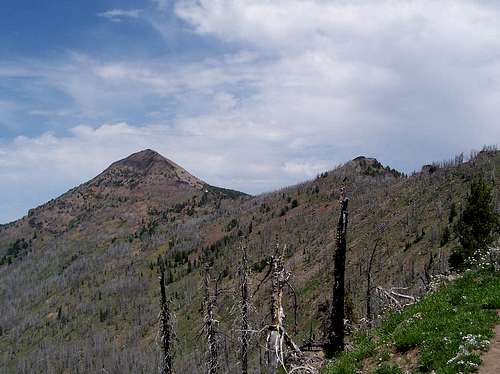
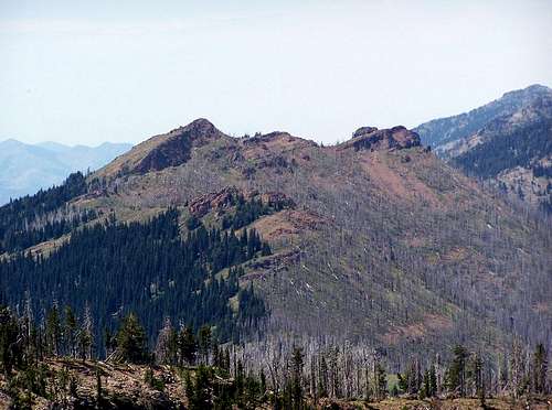
At left, the route: The Roads End / South Route travels just beneath this ridgeline and around the summit cone on its east side to the north face of Strawberry Mountain. Once on the north side bench just below the summit, the trail switchbacks up the north and east faces to the top.
Essential Gear
Water. There is a small spring early into the hike but it may be dry during summer months, and the spring is mostly a mud hole that the trail runs through.NOTE:
This route is largely inaccessible during the winter as the trailhead is over 7000 feet. Depending on snowpack for any given winter, you should be able to reach the trailhead from late may to november.

Redwic - Sep 30, 2011 11:35 am - Voted 10/10
Fun FactI just learned this fun fact from the Malheur National Forest Ranger District: Roads End Trail #201A is entirely an old roadbed that has been converted to trail. The trail/roadbed ends at a three-way trail intersection (with the other trails being Pine Creek Trail #201 & Onion Creek Trail #368). Hence, the "Roads End" name is not in reference to the trailhead location, but rather the top-end of the trail/roadbed itself.