Welcome to SP!  -   
 
 MbPost.com -- It's SP for Mountain Biking!
Areas & Ranges·Mountains & Rocks·Routes·Images·Articles·Trip Reports·Gear·Other·People·Plans & Partners·What's New·Forum

Argonaut S Route [ Sizes: Orig | Large | Med | Small | Thumb ]
Argonaut S Route
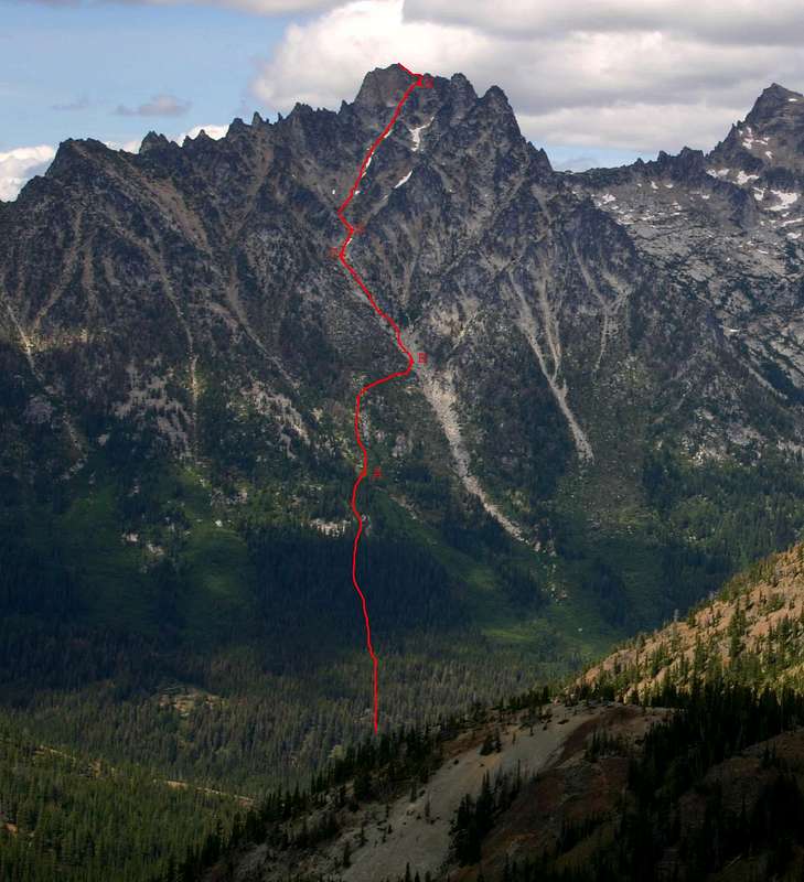
Topo of South Route on Argonaut Leave Ingalls Creek trail 50 paces E of Fourth Creek junction. Cross small creek into open meadow at 5600' (A). Cross into main gulley draining peak at 6300' (B). Stay right in main gulley at 6900' (C). Either gulley works at 7100' (D), but left is recommended. The last 50' before the ridge crest (E) has one exposed class 4 move.


Comments

No comments posted yet.


Sign in to post!

Don't have an account? Register now.


Rate This Image
Current Score: 86.74

Log In To Vote
 Argonaut Peak (Mountain/Rock)


« PREV

Viewing
#38 of 69
GALLERY

NEXT »

 dsweld's Image Gallery


You are at
the First
Image

Viewing
#1 of 12
GALLERY

NEXT »


 South Route (Route)


Image Data

Submitted by dsweld
on Aug 26, 2006 3:54 pm

Image ID: 219286
Hits: 611 

Image Type(s): Topo/Diagram


"Remember that behind every sleazy lawyer is a sleazy client."

© 2006 SummitPost.org. All Rights Reserved.