
-
 2295 Hits
-
 74.01% Score
-
 4 Votes
|
|
Route |
|---|---|
|
|
42.68360°N / 0.55013°E |
|
|
Mountaineering, Scrambling |
|
|
Spring, Summer, Fall |
|
|
One to two days |
|
|
PD- |
|
|
Class 4 |
|
|
II |
|
|
Overview
 Waterfall
The normal route of peak Boum it’s the north face (French valley of Lis) but it’s possible to realice it with two options according if we’ll sleep in the refuge or not.
Slope: 1990m (630m from the refuge)
Time to summit: 5h 30min (2h 15 min from the refuge)
Getting There
see the main page.Route Description
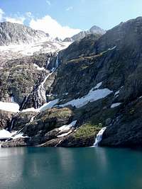 Lac Bleu
The beginning it’s the same of peak Maupás: We’ll begin crossing the river in entry of the parking and we follow the path #40 (signalled with a yellow circle) across a hard slope in the forest of beeches. After the forest we’ll reach a grassy plateau and we’ll turn to left (north) leaving the route to waterfall of Enfer in right side. Always we'll follow the red paint of route of refuge of Maupas (in many occasions joined to the green of Lac Vert and the bleu of Lac Bleu). The itinerary goes across the grassy ground among a lot of flowers and little rivers, and ascent across the ravine. We’ll cross some bridges before to arrive to the plateau Prat Long. Here’s the moment of the bifurcation. Just before the tube and cables we’ll can to see a signal of paint with the indication of Lac Bleu in left side.
a)-Across the Lac Bleu: it’s shortest itinerary, but some points are difficult to find, specially if it’s covered by the snow. Some stepcrossings are exposed and had some fixed mettallic rope before the lake. No difficult in summer but with snow it’s not very advisable. We’ll follow the blue paint to the marvelous lake and in the left side we’ll take some little paths to the upper plateau. It’s needed the use of the hands in some point. We’ll reach a great plateau under the north face of peak and we’ll walk in direction of left of the summit, the great channel between the peaks Mall Barrat and Boum.
b)-Across the refuge: in the area of cable way, we’ll get a path in zigzag with very hard slope near of the tube and the cables. Some indications in red paint in the column show the entry of refuge de Maupas (3h30min). we’ll go to left side (west) and we’ll evitate the Tussé de Maupas. We’ll try to search the way to right when we’ll walk under the peak Tussé de Maupas and we’ll reach the little glacier. In a chaotic area with some kasrtic rocks we’ll walk searching some carins to reach the same point of option a).
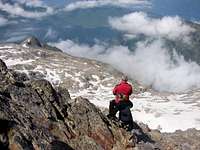 On the ridge NE
 Rock-climb
In the channel we’ll walk in the middle in direction to the col (20-25º). With snow probably the best option is reach the col with the peak Mall Barrat entering in the west face of peak searching the pass to right side to get the ridge SW. Without snow is possible to get the ridge before to reach the col (some cairns). The ridge SW had some terraces and some little walls of I. Near of the summit we’ll find some rock-climb of I+ with good stone. In direction always to the great cone of summit we’ll find finally the chimney to access to the summit (attention to cairns). The chimney had two great stones in 2-3 meters with grade II. The climb is easy but exposed to reach the narrow summit of Boum (3006m). Enjoy the superb views!
Essential Gear
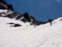 Col Barrat
Early in the season (may, june) is very advisable the use of crampons and ice-axe. In july generally the little glacier is visible without snow and some meters before the ridge SW we’ll need to walk on it. The crampons are usefulls.