Toggle navigation
Mountains
Routes
Images
Trip Reports
Forum
What's New
People
Areas & Ranges
Articles
Trailheads
Canyons
Huts & Campgrounds
Albums
Logistical Centers
Fact Sheets
Lists
Custom Objects
Gear
Plans & Partners
WELCOME TO SUMMITPOST
SIGN IN
REGISTER
Trapper Peak
Additional Parents
Image
All Trapper Routes
View High-Resolution Image
All Trapper Routes
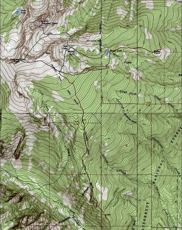
This topo map shows the routes originating from the Standard Trapper Peak Trailhead and the Baker Lake Trailhead.
Red
(vertical)
-
Standard Trapper Peak Route
(trail 133)
Red
(horizontal)
- Baker Lake TH to Baker and Gem Lakes
Purple
-
Baker Lake Ridge Route
Blue
-
Gem Lake Gully Route
Green
-
Northeast Couloir Route
Fuchsia
- North Trapper Peaks
Olbu Southeast Face Route
« PREV
NEXT »
Michael Hoyt
on
Sep 1, 2007 7:15 pm
Comments & voting
Other parents
Lat/Lon:
45.88989°N / 114.29685°W
Image Type(s):
Topo/Diagram
,
Informational
Image ID:
331599
8929 Hits
74.01
% Score
4
Votes
Log in to vote
Comments
No comments posted yet.
to post!
Don't have an account?
Trapper Peak
(Mountain/Rock)
« PREV
Viewing
#27 of 92
GALLERY
NEXT »
Michael Hoyt's Image Gallery
« PREV
Viewing
#847 of 1801
GALLERY
NEXT »
×
You need to login in order to vote!
User Name
Password
Remember me
Forgot your password?
Log me out when I close my browser.
Keep me logged in all the time.
sign in as a user
Don't have an account?
Register now for FREE
Rating available
Suggested routes for you
People who climb the same things as you
Comments Available
Create Albums
Register Here


