
Comments
No comments posted yet.
|
|
Trip Report |
|---|---|
|
|
46.01830°N / 110.277°W |
|
|
Jul 30, 2006 |
|
|
Hiking, Scrambling |
|
|
Summer, Fall |
|
The Crazy Mountains are an isolated mountain range that offer many different access points. One of the more popular trailheads is at Half Moon Campground north of Big Timber. From this trailhead, the trail follows Big Timber Creek past the lower falls, and crosses the creek several times. This lower trail is usually heavily used in the summer (by Montana standards, that is). Slightly over 2.5 miles up from the trailhead, there is a obvious, and well marked offshoot trail to the left. This trail leads to three lakes: Thunder, Blue, and Granite. Last summer, my roommate and I made a trip out to check out this area that I had heard about from a co-worker that frequently gets out in the Crazies. We ended up leaving Bozeman at an ungodly time, something like 11:00pm or so. It was kind of a handful (even with a GPS) trying to find the access road to get to the campground in the pitch dark. We eventually got out to the trailhead about 1:00, and set up camp by 3am (before having a few deer on the trail freak us out a couple times). We camped between Granite and Blue Lake, but off the trail enough to not get too much foot traffic through camp.  Route detail Route detail |
 View from just above camp, looking at Granite Peak, with Blue Lake visible to the right View from just above camp, looking at Granite Peak, with Blue Lake visible to the right |
 Lakes everywhere! Lakes everywhere! |
|
The next morning, we slept in a bit to compensate for the late night hike. It was great to wake up and actually see where we were situated with respect to the mountains, and not just my GPS unit. Crazy Peak's false summit loomed across from us, showing it's heavily-scoured ridgelines.
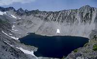
We pumped some water and were on our way, just doing a scramble for the day to check out the surrounding area. The goal was to get up and follow a big ridge going west. The ridge would take us between two larger lakes, Pear Lake on the southern side, and Druckmiller on the northern end. The scramble turned out to be fairly slow going, due to the shape of the rocks. Most were not very thick, but large in size, like two-inch dinner plates. Unfortunately, every time you put weight on a given rock, there was no telling what would happen. Several times, we both had a unnerving ride or two, where a rock would take off sliding with us windmilling and trying to figure out how to bail off. We both managed to only get banged up ankles and torn up palms, but the views alone made up for the effort. |
 The scramble up the ridge The scramble up the ridge |
 Looking West Looking West |
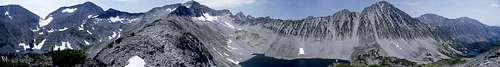 Panorama Panorama |
 |
 |
 |
 |
 |
 |