An Early Morning
Mountains: Little Pawnee Peak (12,466 ft), Pawnee Peak (12,943 ft)
Route: Started at the Long Lake TH, bushwacked up to Pawnee's east ridge after Long Lake.
Stats:
Elevation Gain - 3100’ (approx)
Total Mileage - 14.65 miles (4 miles of biking on the road)
Round Trip: Approx 9 hours.
[Beep][Beep][Beep]
It's 3am. Sometimes I wonder why I do this to myself. My alma mater, The University of Connecticut, had a big basketball game the night before, so I went out to the Streets of London to watch the game downtown. The 3am start was a little harder than normal. I checked the weather report for Indian Peaks: Partly to Mostly cloudy with 10% chance of precipitation. Nice. After a quick breakfast, I was off to Golden to meet Brian and Jack.
We all headed up in Jack's truck with 3 bikes in the bed. Who's idea is it to close the road up to Brainard Lake when there is no snow on the road?
We arrive gate and meet up with Stephanie, who came down from Fort Collins. This is our team for the day.
We gear up, hop on our bikes, and head up the road at about 5:45am. It's a chilly morning, and the wind was stiff into our faces. After about 30 minutes we are at the Long Lake TH, ditching the bikes and ready to roll...
![1 Pawnee East Ridge GPS Track]() The GPS Track for our route...
The GPS Track for our route...The Bushwack
Our plan was to hike just past Long Lake, and bushwack up to Pawnee Peak's east ridge. After a quick hike on the Long Lake Trail, we started up the forest to the ridge.
![2 The bushwack to the ridge]() The forest up to the ridge. Snow was a non-factor.
The forest up to the ridge. Snow was a non-factor.
The bushwack was straight forward, and we made short order of the forest with no problems. As we left the trees, the sunrise gave evidence of some instability in the atmosphere.
![3 Sunrise from the East Ridge]() The clouds at sunrise.
The clouds at sunrise.
Snow began to fall, first as flurries, then becoming a steadier light snowfall. This would be our weather for the rest of the day. So much for the 10% chance of precipitation. The Continental Divide was socked in. We all agreed we'd ascend the ridge and assess the situation as we progressed, not wanting to get in over our heads on an exposed 4th class route.
Stepping Onto the Ledge
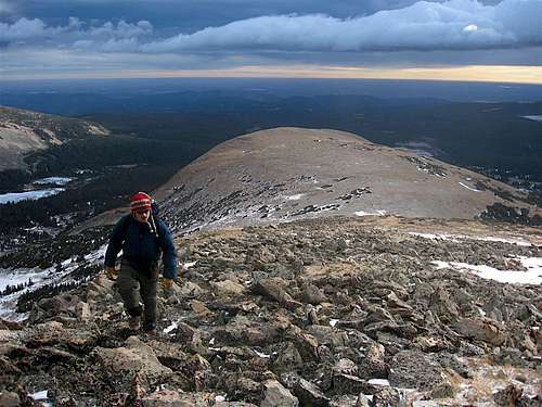
We hiked up the gentle slopes of the east ridge, on route to Little Pawnee Peak, a jagged highpoint along Pawnee Peak's east ridge, sitting at 12,466 ft in elevation.
![5 East Plains]() Brian ascending the east ridge
Brian ascending the east ridge![7 Mt Audobon Panorama]() Looking to our right, we could see Mt Audubon
Looking to our right, we could see Mt Audubon![8 The View South Panorama]() Looking to our left, we could see the Niwot Ridge.
Looking to our left, we could see the Niwot Ridge.
The gentle slope comes to an abrupt halt when you reach a notch just before Little Pawnee's summit. The weather was still overcast, but we had no trouble with the few 4 class moves required here.
![7a Down Climbing the notch]() Brian down climbing the notch.
Brian down climbing the notch.
Hop over a few more rocks, and you're at the summit of Little Pawnee. Visibility was no more than 100 ft.
![9 Brian on Little Pawnee]() Brian on the summit of Little Pawnee.
Brian on the summit of Little Pawnee.
Windy and cold on the summit, we decide to move on. Many say the down climb off of Little Pawnee is the crux of the traverse. Well, we found a ledge system about 50 ft below the summit on the north face that traverse around to the west side of the peak.
![10 Descending Little Pawnee]() Traversing around little Pawnee. One five foot section is very exposed, but never above 3rd class.
Traversing around little Pawnee. One five foot section is very exposed, but never above 3rd class.
What followed was about 20 ft of 4th class down climbing to leave Little Pawnee's summit block.
![Downclimbing Little Pawnee]() Climbing down the last 20 ft of Little Pawnee.
Climbing down the last 20 ft of Little Pawnee.
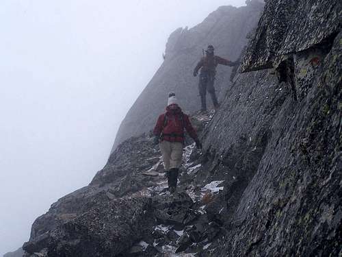
What follows Little Pawnee is a series of knife edge ridges and north facing ledge/gully traverses. Descending Little Pawnee was not the crux of the route. The next half mile of ridge line was.
It's all a little blurry in my memory. All the gullies and ribs we crossed looked eerily similar to each other.
![12 Traversing the North Face]() Traversing one of many ledges. You can see me if you look carefully.
Traversing one of many ledges. You can see me if you look carefully.![14 Some Spires along the Ridge]() Spires just before the mellow knife edge.
Spires just before the mellow knife edge.![13 Downclimbing a gully]() Brian climbing down a slick gully.
Brian climbing down a slick gully.
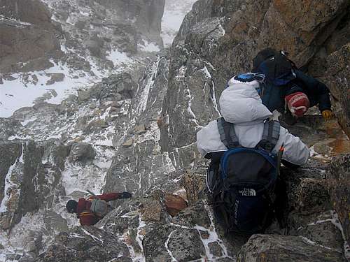
Somewhere in the middle of the traverse, we ran into a large snow-filled gully. The snow was not well consolidated, and was easy to cross. The ledge on the other side of the gully worried me a bit more. It was very exposed.
![15 - More Ledges]() The ledge system just across the snow-filled gully.
The ledge system just across the snow-filled gully.
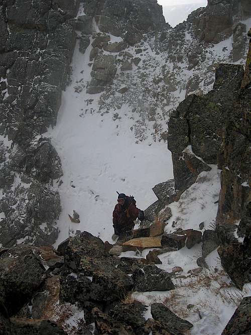
Here is a view from the top of the ledge back at the snow-filled gully we crossed.
![16 - Climbing the Ledge]() Me taking in the exposure with the gully in the background.
Me taking in the exposure with the gully in the background.
From here, we traversed another series of slick ledges, finally reaching the end of the jagged ridge. We headed straight up to the ridgeline.
![17- Almost there...]() Heading up to the ridgeline from the north face.
Heading up to the ridgeline from the north face.
The ridge mellows out as you close in on the summit.
![18-The Final Push to Pawnee]() Almost there!
Almost there!![19-The Summit of Pawnee Peak]() Stephanie, Jack and Scott on the summit of Pawnee Peak.
Stephanie, Jack and Scott on the summit of Pawnee Peak.
The summit offered spectacular views of the Indian Peaks Wilderness. Mt Toll, Navajo Peak, Mt Audubon can all be seen here.
![20-Spectacular Views on Pawnee Peak]() Taking in the scenery.
Taking in the scenery.Let's Get the Hell Outta Here!
Thoughts of traversing over to Shoshoni Peak were long gone. The east ridge in snowy conditions took a lot out of the entire group, and we were ready to get out of the wind.
Our descent route took us down to Pawnee Pass, where we would hook up with the Pawnee Pass Trail back to Long Lake. The wind was strong and the visibility was low. Jack got hit by a gust and was knocked over for a second.
The Pawnee Pass trail was not easily found with snow cover. We approached a steep gully and had to take out the topo to figure out where the trail was. After a brief conference, we decided the trail was a little above us and to the south. Sure enough, there it was about 100 ft above us.
![21-Descending after Pawnee Pass]() Descending some small snowfields towards Lake Isabelle and Long Lake.
Descending some small snowfields towards Lake Isabelle and Long Lake.
A fantastic view of the east ridge on our way down.
![22-A view of Pawnee s East Ridge]() Pawnee's east ridge.
Pawnee's east ridge.
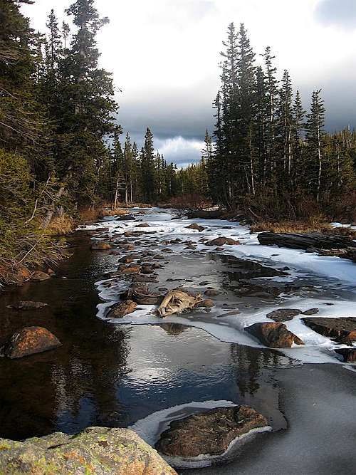
We ran into a few people down at Brainard Lake, where we got another great view.
![24 - A Stream]() A stream near Brainard Lake.
A stream near Brainard Lake.![23-Lake Isabelle]() Lake Isabelle.
Lake Isabelle.
We hopped back on our bikes and made quick work of the road. It couldnt have taken more than 10-15 minutes. Bikes were a great idea.
The End
What a great scramble. Our group was strong and had no trouble with any of the obstacles along the route. This was my second trip to Indian Peaks, and it is quickly becoming one of my favorite ranges in Colorado.
The climb itself is would be a fun scramble in dry conditions. With the 1-2 inches of snow that fell during the day, the difficulty was raised a notch or two. Many of the rocks had a light coating of snow, making them slick. Extra care was needed, but the ridge was doable with solid scrambling skills. I carried my crampons and ice axe, but they were useless in the shallow unconsolidated snow.
I highly recommend this seldom traveled route, although you'll probably want to wait until next spring with the snow forecast for this week!
P.S. Thanks to Stephanie and Jack for providing many of the pictures in this report!


Comments
Post a Comment