Overview
Morocco has a lot to offer to any mountains enthusiast. The huge Atlas range boasts numerous summits to explore on foot or on skis; wild rivers have carved deep canyons which are fun to explore during the hot summer thanks to their fresh waters; the picturesque Berber villages add a human touch to this mineral wonderland. South of the Atlas the enigmatic Djebel Sarho with its strange looking rock formations stand on the edge on the Sahara.
All this sounded great to my ears. It wasn’t very difficult to convince my friends Bob and Cousteau to join me for a two weeks trip.
Marrakech
At the beginning of November 2004 we land in Marrakech with a very vague plan of crossing the Atlas and maybe the Djebel Sarho too. First of all we go on a hunt for good topographical maps. We have decided to go on our own, without guides or porters because we are quite sure that they wouldn’t want to cross the Atlas at the beginning of winter and moreover we want to do it the hard way: with heavy packs and the pleasure to find our own path.
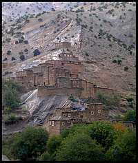
Having found the coveted maps we leave Marrakech on the first morning bus, thus postponing the visit of this fascinating city and its bazaars until our return. A day of bus and taxi take us close to Agouti, a mountain village where most treks for the M’Goun (4’068 m, the second highest summit in Morocco after Djebel Toubkal) start.
Into the Central High Atlas
Map of our trek in the Central High Atlas
We have a week’s worth of food in our backpacks and that’s the time we reckon it will take us to reach Boulmane on the south side of the range. With still a few hours of light left and a mellow autumn temperature we start up the Aït Bou Oulli valley on a good path which meanders between groves of trees and small villages strangely reminiscent of Tibet for me.
It’s hard for the Berber population to eke out a living in those barren mountains, but poverty and an important trekking industry don’t prevent them from being friendly and helpful with directions – a common feature of all mountain people I’ve had the chance to meet so far. It’s another story with their children who pester us for pens, candies and money, a sure sign that well meaning but ill informed package trekkers ply those parts during the good season.
Fortunately now with the coming winter we are almost alone in the mountains: we won’t meet any other trekker and only few Berbers outside their villages during those two blessed weeks in Morocco.
The next day is spent climbing up the beautifully varied Aït Bou Oulli. Rougoult – the last village we see for a while – stands on a steep spur of the mountain. The weather is freshening while we climb towards the Tizi Rougoult (2860m; “Tizi” means “Pass”). A strong cold wind greets us on top so that we don’t spend too much time enjoying the grand view and start down tiring scree slopes.
The Wandras canyon
We have reached the upper part of the broad Tessaout valley. We camp at the end of the impressive Wandras canyon that we plan to explore on the following day. But for now we only think about warming ourselves and for that purpose the 1-liter Laphroaig Cask Strength bottle bought at the duty free in Geneva proves very handy!
The wind blows ferociously the whole night. It rains then snows and we wake to find miserable weather outside the tent. But we can’t wait to see the famed Wandras canyon and start despite the furious gales. Soon the weather clears and reveals the sheer beauty of the Wandras:
a 500 meters deep, 8 kilometers long canyon of vertical red walls.
We follow the narrow river, occasionally climbing among mazes of fallen boulders. Time flies when there is so much beauty to revel in. Every bend of the canyon hides a new waterfall, a more imposing chaos of rocks.
It would be possible to follow the canyon up to the high Tarkeddit plateau, north of the M’Goun, but we’ve planned to go south instead and head back down unwillingly.
South of the M’Goun
The next day we cross a windy pass before arriving at a small Berber village. Everyone seems to be inside due to the severe cold except a young shepherd buried under a few blankets. We keep going and reach a 3000m high pass. It has snowed up here and we’re treated to a grand view of the mellow-shaped M’Goun.
Winter has come to the Atlas: everything lies under a thin layer of snow and it’s cold. We spend the night inside a deserted “azib” – a stone hut build by shepherds for their summer pasture. The temperature falls to -10° C during the night, definitely not your standard preconception when thinking about Morocco.
Our food situation is getting bad. Cousteau was responsible for our food supply but his peculiar sense of humour made him think that we could contend ourselves with a risotto package for the three of us at night. He even purchased such delicacies as 100% fat and joints corned beef (see later what happened to it). Well we’re hungry but it doesn’t prevent us from having a great time in the deserted M’Goun range.
For two more days we walk up and down snow-covered passes and among gorges until finally we reach more open land with a cluster of big villages.
The Valley of the Roses
Boulmane is still 50 kilometres away and we don’t feel like walking along the flat dirt track. We decline a first offer of a lift and end up paying twice as much when we start negotiating for a taxi in the next village. That’ll teach us to try and outsmart Moroccans. But all in all the 30 euros we pay aren’t a rip off considering the awful state of the track.
We drive through the exceedingly beautiful “Valley of the Roses”. As usual green is only to be seen at the bottom of the valley, while the mountains are a barren waste. We have a last glimpse of the dazzling white Atlas then speed towards our next goal, the Djebel Sarho.
Resting in Boulmane
Boulmane is a quiet middle-sized town with a typical Moroccan architecture. We have a few good meals, drink the sweet mint tea, talk to our new friends in the warm afternoon sun. As soon as it gets dark the temperature plummets and suddenly it’s winter again.
It’s the end of Ramadan, the holy month of fasting in Islamic countries. Men rest and talk on the roof of our hotel. Some of them smoke marijuana in small pipes, another even drink a local figs alcohol. I’m invited to join in. He explains to me that, since Islam has been brought here by the Arab invaders (centuries ago; in Marrakech and south of the Atlas most people are Berbers, the native population of a long time ago), he doesn’t feel the need to comply with the prohibition of alcohol or the fasting.
He is the one who commits the sin but I’m the one who pays for it: I’m violently sick at night while my friends hunt for carpets and souvenirs.
Exploring the Djebel Sarho
Map of our trek in the Djebel Sarho
This range lies between the Atlas in the north and the Sahara in the south. Due to its modest elevation (max 2592m) it’s pleasant to visit in winter. In summer it can get unbearably hot (well over 40°C). The Sahara can be felt here: there’s only a scattering of palm trees around water holes. Save for those few dots of green it’s a waste of red and brown rocks.
For four days we wander through a maze of unbelievable rock formations. Erosion must be a comic chap because we can make out an elephant, a camel, a hand among the spires of rocks.
We thought that it would be difficult to match the wild beauty of the Atlas and feared to be disappointed with the small Djebel Sarho. Now we realise that despite its small size and low elevation, Djebel Sarho can boast a fair share of natural wonders.
We try to take in as much of this beauty as possible by exploring dead ends, climbing strange shaped rocks or going round them a few times. And at the end of the day we always find a paradisiacal camping spot. What can one ask more of life when one is in such a place, with two good friends, fine weather and a bottle of top Scotch whisky?
We manage to get lost one more time but as we stumble upon a pretty little canyon with a stream of clear water in it we decide to keep going. It’s here that we meet women with their flock of sheep. One of their dogs chases us. He doesn’t look to scary so we try to befriend him. We still have our abject corned beef to help us in this matter. He’s probably never had such a good meal for he follows us for the next two days. We’re more than happy to see that we haven’t carried those tins in vain…
The end
We’re back in Boulmane. Our friend Mohammed is quite willing to sell us all the carpets and daggers we want. Then it’s the long drive back to Marrakech where we still have a bit of time left to visit the huge bazaar.
We’ve made the most of our two short weeks in Morocco. Friendly people and the beautiful and varied mountains where they live in will leave a lasting impression on us. There is still so much left to see that we’ll sure be back someday…
Practical information
M’Goun page on Summitpost
The best trekking guide of Morocco: Montagnes du Maroc (trekking and backcountry skiing, only in French)
Topographical maps of Morocco can be hard to find. Some are available to download for free: check out this very good
fact sheet by Corax . In particular you'll find some 1:000'000 maps of the Central High Atlas
here.


Comments
Post a Comment