First Attempt- February 3rd, 2008
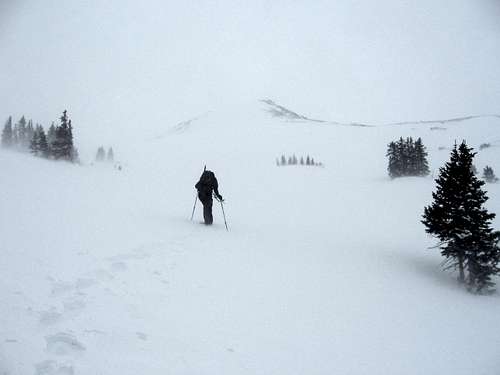
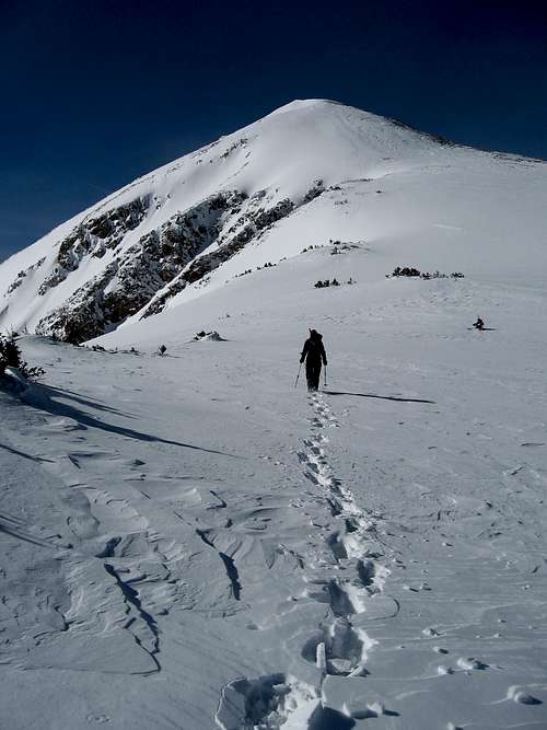
12,600 feet, 12:30 p.m. Kim and I sat huddled behind a rock on Keller Mountain's east ridge as relentless wind and snow ripped across the talus. We could hardly see. My backpack was covered by spindrift a few seconds after I took it off. We'd been moving for over seven hours, and the sudden inactivity brought cold. My fingertips were going numb. Conversation was nonexistent. We both knew we had to turn around. Full Colorado conditions, like we've had so often this winter, prevailed. Nonetheless we were happy to have made it this far—-thanks to Summitpost, we had begun the day as total strangers, meeting at 3 a.m. in a desolate parking lot in Fairplay. We had climbed well together, and seven hours of trail breaking had gotten us deep into the Gore Range, a spectacular, incredible place. I don't think either of us wanted to turn around, but the conditions were just too much. As the wind raged on, we snowshoed back to the car. We were thawing out and eating burgers at the Breckenridge Brewery in time for the last quarter of the Super Bowl, but neither of us was watching. We wanted to go back up.
![Wintertime...]() Kim hikes into the wind on the first attempt.
Kim hikes into the wind on the first attempt.Second Attempt- February 10th, 2008
A week later, we met in Fairplay again, on a Sunday morning just after 3 a.m. It's a little strange, driving through Fairplay in the middle of the winter at three in the morning. A couple of errant snow ghosts blowing down Main Street were pretty much the only sign of life.
Kim's Tacoma was, as expected, the only vehicle in the empty grocery store parking lot. I picked her up and, as we pulled onto the highway, I could tell it was going to be a good day, as we were both in good spirits and eager to get out into the backcountry. The forecast called for a few clouds and calm winds. I couldn't believe Kim was as energetic as she was, considering the lack of sleep (having driven up from Golden) and the 70 miles of road biking she had done the day before. But we were both wide awake, enjoying good coffee and conversation for the duration of the drive. On the sheet of ice and snow known as Highway 9, we made our way over Hoosier Pass, through Breckenridge, Frisco, and Silverthorne, and finally to the Rock Creek trailhead by 4:30. Snowshoes on, packs packed, I guzzled the rest of my coffee and we hit the trail.
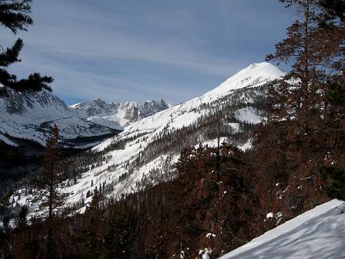
![Keller Mountain]() Keller Mountain as seen from the east ridge.
Keller Mountain as seen from the east ridge.
The winter closure of the Rock Creek road is something like three miles from the summer trailhead, which makes for relatively simple routefinding at 5 a.m. Though the sky was completely clear, we could see what looked like light, crystalline snow falling in the light of our headlamps. Kim set a quick pace up the snow-covered road to the summer trailhead, and to the intersection with the Gore Range trail a short distance further. It had been snowing all week, and the trail had only been packed down by a couple of skiers, making for awkward walking in snowshoes. We followed the Gore Range trail north for a half mile or so, to a clearing in the aspens. Here we veered west and headed uphill, straight up the nose of Keller's lower east ridge.
![Beetlekill Sunrise #2]()
Kim took a long turn breaking trail, straight uphill in deep snow. Not just deep snow, but bottomless snow, full of punchy, unsupported crust layers. Breaking trail in this stuff is hard enough on level ground, much less a steep slope in tight trees. But it quickly became clear that Kim meant business—-the word “tired” holds very little meaning for her. After an hour or so we traded places and I began breaking trail where the ridge crest leveled out a bit. The sky, almost completely clear, was beginning to lighten. For the next half hour we watched a brilliant orange sunrise over our shoulders. The trees around us began to take form—most of them standing dead orange skeletons, ravaged by bark beetles.
![Beetlekill Sunrise]() The view to the west, looking up the Rock Creek drainage. Keller Mountain is on the right, with the Grand Traverse in the background.
The view to the west, looking up the Rock Creek drainage. Keller Mountain is on the right, with the Grand Traverse in the background.
After we gained the ridge, the going was a bit flatter and easier, but still plenty of work in the deep snow. Probing with my upside-down ski pole, I couldn't find the bottom of the snow in most places. We found what might have been our trail from the week before, only the slightest suggestion of the trench that we had created, covered in two or three feet of snow. As we continued up the ridge we found some small, round tracks. I wasn't sure what had made them, but it was headed the same way as us, so we followed it for quite a ways, over a mile, right on top of the ridge crest in the trees. The tracks were fresh, and I could see a couple of places where it looked like the animal had stopped and looked back, almost as if it had been watching us. We were hoping we would see it at some point, but we never did. (When I got home, I looked the tracks up in a tracking book—my best guess is that it was a bobcat leading us up the mountain.)
![Breaking Trail]() Breaking trail in some deep, deep snow.
Breaking trail in some deep, deep snow.
We took more or less the same route as the previous weekend, finally ascending out of the beetlekill and into the healthy spruce-fir forest just below timberline. The snow was even deeper here, but we didn't hear any whumpfing, which surprised me. We took our first real break of the day somewhere around 11,500 feet. I don't remember what time it was, probably 10 or 11 a.m. We ate and drank for a while in the sun, with absolutely no wind. What a difference from the week before.
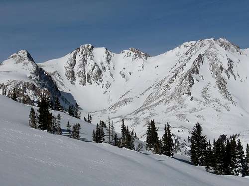
![Peak Z and Z]() Looking north from 12,000 feet or so at Z' and Z.
Looking north from 12,000 feet or so at Z' and Z.
This was our longest rest of the day, a luxurious fifteen minutes, and then we were on our way again. The day of the climb, the avalanche rating from the CAIC was 'considerable.' The snowpack discussion mentioned the Gore Range specifically, saying “...some large slides were reported on the East side of the Gore, E & NE aspects, running 1000 feet and longer.” New snow had formed good-sized soft slabs on all lee slopes and deep, hard slab avalanches were also very possible. With all this in mind, it was definitely a day for 'a-game' routefinding. The most avalanche-prone part of many winter routes in Colorado is the area between the highest trees and the lowest wind-scoured part of the ridge, and this route was no exception.
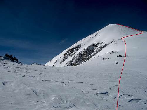
![East Ridge Route]() Our route (more or less) through avy terrain just above timberline.
Our route (more or less) through avy terrain just above timberline.
As we ascended into sparser clumps of trees, we could see a steep, open bowl above us and to our left, so we traversed to the right, into the highest trees. Another large, steepish bowl kept us from continuing all the way over the wind-scoured north (right-hand) edge of the ridge. Instead, we stayed to the left of this larger bowl and ascended a rib to climber's left, just above the highest trees. Here, we found a lower-angled bench between two steeper slopes on which to cross over to the wind-scoured talus. This section made for some fairly intense route finding, but fortunately the slope wasn't as steep as it had looked from below.
![Ascent]() Kim breaking trail... again.
Kim breaking trail... again.
We reached the rocky edge of the ridge at 12,500' at around noon. There was still quite a bit of mountain left to climb, but the weather was holding solid. We agreed on a turn-around time of 2 pm. Then it was straight uphill again, actually staying just to the left of the rocks on some hard sastrugi snow. We cruised past our first attempt's high point. Summit County was beginning to drop away below us... I felt like running up the mountain. Suffice it to say the stoke level was plenty high. It felt good to gain some quick elevation—-it's amazing how much faster you can move when you're not breaking trail in deep snow.
![East Ridge]() Gaining some elevation on nice hard snow...
Gaining some elevation on nice hard snow...
Soon, we summited the first sub-peak of Keller Mountain (Pt. 12,847') among staggering views. I had a hard time making myself believe I was actually seeing what I was seeing. The Peak X-Y-Z ridge rose sharply to the north, the Grand Traverse to the southwest, and Valhalla to the south, with countless other snow-clad Gore Range summits appearing as we continued up. The Blue River valley sank far beneath us to the east, with the Front Range and Indian Peaks forming the eastern horizon. Once again we found ourselves following someone else's trail, this time an ambitious mountain goat. Its tracks were fresh and led us to the first sub-peak, but then disappeared somewhere below the ridge.
![Rock, Snow & Sun]() The view to the northwest from 12,500'.
The view to the northwest from 12,500'.
From just below Pt. 12,847, we had a good view of the rest of the route. To our relief it looked pretty well windscoured, with lots of exposed rock, but it was hard to tell how easy it would be to downclimb into the notches. As we started across the ridge, Kim decided she would be hardcore and climb directly over some low class-5 features instead of traversing around them. Of course I had to follow her—there are few things as much fun as climbing over boulder problems in gloves and snow boots with hundreds of feet of exposure on either side. It was a short scramble over to the second subpeak, a nice aesthetic pyramid. At this point, the easier ground leading to the third subpeak looked temptingly close, but we still had the most technical section to cross before we reached it.
![Upper East Ridge]() The final portion of Keller's class 3 ridge.
The final portion of Keller's class 3 ridge.
I don't remember exactly where we had to drop below the ridge crest, but there were several features on the ridge that we weren't sure we wanted to downclimb the far side of. At each of these places—-I think there were four—-we dropped to the left (south) side of the ridge crest, just above the many windloaded, avy-prone slopes below. At these spots we encountered some deep, powdery snow which didn't provide much comfort in the way of ice axe belays, but it went. The last challenge was a short, steep step on extremely hard snow next to a boulder on the ridge crest. I spotted Kim as she scrambled and dry-tooled her way up this, then followed in her tracks (on the way down we cut steps on the hard snow to descend this part).
![Sunday Stroll]() Nothing like a little exposure.
Nothing like a little exposure.
From here, it was easy going to the third subpeak, but the wind had started to pick up. It would be calm for a minute or two, then a strong gust would come up and sandpaper any exposed skin with spindrift, then die again. From the east ridge it's easy to see the final summit ridge, leading south a few hundred yards from the third subpeak.
![Keller & Pileus cloud]() Looking up at the final summit ridge.
Looking up at the final summit ridge.
Viewed from the east ridge, the summit ridge had looked heavily windloaded and unstable, so I had been wondering if we would be able to cross it. But as we summited the third subpeak, we could see that the ridge was completely windscoured on the windward side, meaning we could safely cross it. On the lee side, a huge cornice had grown over ten feet out from the ridge crest. Although it was relatively flat terrain, the going was tough here because of the snow. Where it would support your weight, it was much easier to walk on the thin edge of the snow than the adjacent talus, but it wouldn't always support your weight. I'm not sure why, but Kim seemed to have a great talent for punching through-—I looked back more than once to see that she had sunk up to her waist or higher. It takes a lot of energy to climb out of those holes!
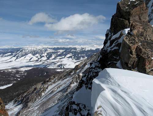
![Aerie]() The view east from the bottom of a steep notch on the east ridge.
The view east from the bottom of a steep notch on the east ridge.
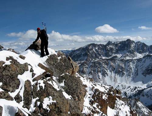
At 2:15 p.m. we reached the 13,085' summit of Keller Mountain, in full sun and strong wind. We didn't spend long up there, partly because of the wind, and partly because we knew we still had almost two hours of scrambling before we could start dropping toward timberline again.
![Keller Mtn. summit]()
![Keller Mtn. summit]()
We had fulfilled the optional part of the day (summiting), and now it was on to the mandatory part (descending). We took a few pictures and turned to head down. I lingered on the summit a minute longer, in awe of the mountains around us. Deep winter in the Gore Range is a place of savage, unrelenting beauty. Jagged rock, wild snow, and death-trap avalanche chutes meet your eye everywhere you look. Though it was my first time on Keller's summit, I felt like was coming back to a place I already knew. Nowhere feels more like home to me than the summit of a wild, remote peak. Although civilization was only a half day's walk out, our position felt far more removed than that. The aesthetic appeal of such a place, of course, belies a much colder, more indifferent demeanor as well, and our time up there was brief and borrowed. We began the descent.
![central Gores]() The view northwest from the top of Keller Mountain.
The view northwest from the top of Keller Mountain.
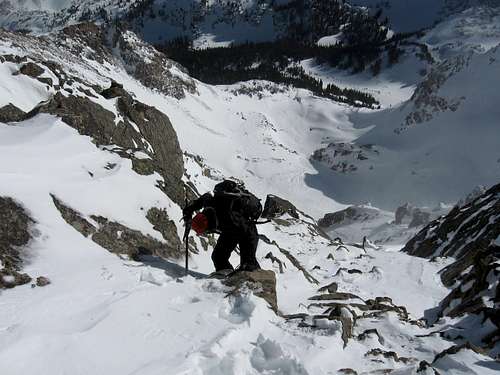
Having made the summit, we now found ourselves fully committed to the route, as we would have no relief from the wind and blowing snow until we traversed back across the ridge and three sub-peaks. We made our way back over the third sub-peak to the more jagged section of the ridge. For most of the day, we had been talking quite a bit, but for the duration of this section we hardly spoke. With only a few hours of daylight left, we knew we had to just put our heads down and move quickly, without falling, getting hurt, or triggering an avalanche.
![Descent]() Kim dispatching the gnar on the way down.
Kim dispatching the gnar on the way down.
When you agree to climb with a new partner, you have no idea what to expect. Sometimes it doesn't work out—-maybe your priorities on the mountain are incompatible, or your pacing is just too different. Other times, though, you get lucky, and find someone whose pace and climbing style complements yours. This was one of those times. The brutal wind gusts and the postholing were definitely taxing, but as I watched Kim moving quickly and solidly across each challenge the ridge presented, I had full confidence we'd make it down safely. Although we'd been working pretty hard for 9 or 10 hours, we made good time getting back across to the first subpeak, where we put our snowshoes back on.
![Southern Gore Range]()
The remainder of the hike down was a push, but relatively uneventful. When we finally reached timberline, we had a hard time finding our trench from the way up, but eventually we intersected it and headed downhill in the trees as the sun was setting. We stopped for a few minutes out of the wind, split a Red Bull and some candy, and pressed on. I had been secretly hoping we'd make it back to the car before it got too dark to hike without a headlamp, but it was not to be. By the time we got down to around 10,000' on the ridge, it was too dark to see. We put the headlamps on and soon hit the Gore Range trail, and then the Rock Creek trail. There were more than a few times during the day when I had wished I had my skis with me, but never more so than during the road walk on the way out. This last leg was a slog. Skiless, I took my snowshoes off and walked the final three miles out on hard packed snow (our pace did noticeably quicken after we made the decision to stop for sausage, mushroom and olive pizza in Breck on the way home). At 7 p.m., we arrived back at the car-—I don't know about Kim, but I was pretty thoroughly cashed. Sitting wearily down in the driver's seat of my Subaru, I grinned-—the notion that we had actually succeeded had just begun to sink in. A waxing crescent moon hung low over the western horizon. I imagined the mountain gods smiling down on us.
The Gore Range has a way of drawing you in—I don't see myself staying away for long. The isolated location, the alpine start, the deep snow, and the great company combined to make this one of the best days I've had in the mountains. Thank you, Kim, for making this climb happen, for lending your expertise, and for making me laugh pretty much the whole day. I'm looking forward to the next one.
Route Data
RT Distance: 17.5 miles/28.2 km.
High Point: 13,085 ft./3988 m.
Total Elevation Gained: 4,680 ft./1426 m.
Car to Car Time: 14 hours


Comments
Post a Comment