
-
 18691 Hits
-
 84.82% Score
-
 19 Votes
|
|
Mountain/Rock |
|---|---|
|
|
49.82860°N / 126.3103°W |
|
|
Mountaineering |
|
|
Spring, Summer, Fall |
|
|
4839 ft / 1475 m |
|
|
Overview and History
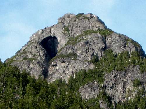
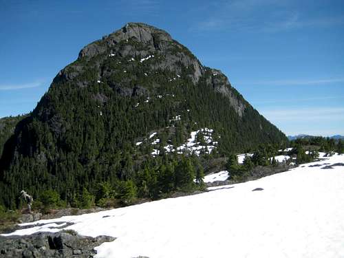 The "Nootka Matterhorn" The "Nootka Matterhorn" |
Located about 10 km NE of the head of the Tlupana Inlet between Gold River and Tahsis on the west coast of Vancouver Island, British Columbia, Conuma is a conspicuous landmark from Nootka Sound and has been a valuable navigational aid for generations of seafarers from the Spanish explorers of the eighteenth century to modern day fishermen and recreational sailors.
It is generally believed that Captain James Cook was the first European to see the Conuma when he sailed into the Indian village now known as Friendly Cove in March 1778 with his two vessels the Discovery and Resolution. It was Cook, in fact, who eventually named the area “Nootka Sound” the name he learned that the natives knew the immediate area by.
The area became pivotal in the struggle between Great Britain and Spain for domination of the west coast and its valuable resources. Both claimed sovereignty by virtue of early landings by Cook and Captain John Meares on the British side and by Captain Juan Perez for the Spanish. War was only narrowly averted by the Nootka Convention of 1794 in which both countries renounced their claims and withdrew from the area. For Spain, this was the beginning of the end of her territorial ambitions in North America. However, it wasn’t until the Oregon Boundary Treaty of 1846 that British sovereignty was formally established as our American cousins gave up their claims north of the 49th parallel.
“Konoomah” Peak is also significant in the lives of the west coast Mowachaht People. Native whale hunters were accustomed to go to the mountain for spiritual purification and guidance. Indeed, it is quite likely that these First Nations people made the first ascent to the summit.
 Conuma Peak East Aspect | 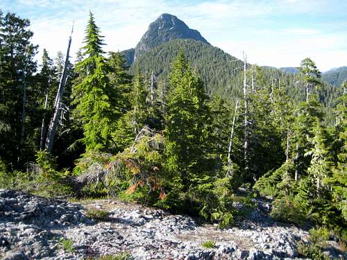 Conuma Peak from the Lower South Ridge | 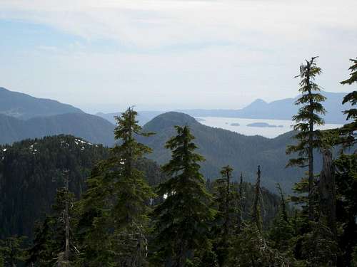 Nootka Sound | 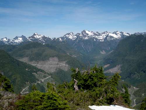 The Alava Bate Sanctuary |
The legendary Island surveyor Alfred G. Slocomb twice visited the summit in 1947 as part of his (and others) Herculean efforts to complete the 1946-1948 topographical survey of the west coast of the Island. The prodigious efforts of Slocomb and his colleagues resulted in the first editions of the maps that we use today.
It was not until 1989 that John Gibson and Syd Watts recorded the first recreational ascent of the mountain by the south ridge.

The natural arch
Oddly enough, none of the early literature makes mention of the huge natural arch on the west face of the mountain. This is a unique feature not only of Conuma Peak but also on Vancouver Island as a whole. Stories of a helicopter flying through the arch must be apocryphal!
Today, the mountain receives few visits. Difficulty of access is not only confined to the natural bastions of bush and difficult rock. Logging reaches far up the sides of the mountain on both the western and eastern flanks and when logging operations cease, the companies deactivate and effectively barricade the abandoned roads leaving the aspiring climber miles of tedious road to walk and, at the end, dangerous “slash” to negotiate. Conversely, when logging is ongoing, the visitor is banned from entry for safety reasons. At the time of writing, one or two routes into the mountain still exist and will be described below. None offers easy passage. Expect no trail, cairns or even flagging anywhere on the approach or the route to the summit. Expect steep, tangled huckleberry and “krumholtz” bush that impedes vision and resists your every attempt at forcing passage. Expect to navigate by dead reckoning with map and compass and/or GPS. Expect complex route finding amongst the bluffs of the summit block itself.
In spite of all this, for the mountaineer seeking a unique challenge, the Nootka Matterhorn is a superb and worthy objective in a visually stunning and historically important setting.
Getting There
Vancouver Island can be reached by air from Toronto, Vancouver, Seattle, Calgary and Edmonton to Victoria, Nanaimo, Comox or Campbell River and by ferry from Port Angeles to Victoria on The Coho and on BC Ferries from Vancouver to Victoria or Nanaimo. Public transport on the Island is notoriously poor and anyone arriving by air would be advised to rent a car.Access in this case involves steep, rough, de-built logging roads with deep water bars. A 4WD vehicle with high clearance is essential in order to get as high as possible on the roads that give access to the mountain. Chains may also be required if the roads are still under snow. This can occur well into May.
From any point on southern Vancouver Island, drive north on the Island Highway 19 to Campbell River. From Campbell River take highway 28 west through Strathcona Provincial Park and onwards to Gold River. Just before entering the town of Gold River, watch for a right turn signed for Tahsis. It’s immediately after the tourist information office. Proceed 2 km on this road and across the bridge over the Gold River. Here the road splits. Right to Woss and left to Tahsis. Note this point on your odometer and turn left onto “Head Bay Road”. The pavement ends almost immediately, but this is good gravel road.
Drive 23 km from Gold River to point where Head Bay Road crosses an unnamed river. We will consider the possible approaches as starting from here.
Approaches
East flank.
Immediately past the bridge 23 km from Gold River turn right onto logging spur H60. Engage 4WD here. Drive approximately 1 km up this road to a fork labeled H60D. The right hand fork is the way that Conuma was approached for many years since Watts and Gibson first used it in 1989. It used to be possible to drive high onto the east flank of Conuma just a short steep hike through old growth to the open part of the south ridge and only a stone’s throw from the summit block. Regretfully H60D is thoroughly decommissioned. The bridge has been removed only a few metres east of the fork described above. Elevation at this point is ~ 250 metres. The road may still be walked approximately 4 km to the point where the old growth comes down to meet it and the climber heads up to the south ridge. This may, in fact, be preferable to the alternative below.
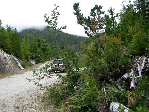 Logging Road H60 | 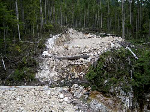 H60D Blocked | 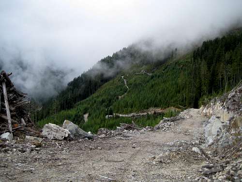 Approach Road. Walk from here. |
Walk up the left fork right to its end in 30 minutes to the start of the route at the usual pile of logging slash at N49° 48.176 W126° 18.809. Starting elevation here is 650 metres.
West flank
Continue approximately 5 km from the H60 turn off Head Bay Road, round the toe of Conuma’s south ridge and cross the Conuma River. Immediately after crossing the river, turn right on Conuma Main logging road. Continue on Conuma Main for 3.5 km to a fork in the road. The turn to the right is marked C15 and that to the left has no marking.
Spur C15 goes right across the west face of Conuma to the end of the hanging valley and puts the climber only 50 vertical metres below the crest of the south end of the south ridge. The left hand fork is used to access the north west ridge and to approach the famous arch from below.
HOWEVER there are several big questions currently hanging over this approach.
- C15 is currently (July, 2008) being very actively logged. Our time on the mountain was punctuated by several huge explosions from below! It might be possible to sneak up after working hours (we did) but this leaves a big question mark over the legality not to mention the safety aspect of this. At the very least, be prepared to wait, overnight if necessary, to sneak out again. Or, do the right thing and call Western Forest Products in advance or visit their Gold River office and get the latest status from them.
- In the event that C15 is, or becomes, driveable be aware that the road is only negotiable to about one third of the way across the west face. Once again, a critical bridge has been removed. Walk up the remainder of the road to an elevation of ~ 850 metres and begin your approach to the south ridge from whatever point you deem suitable.
Summary of Summit Routes
South Face. 350 metres, Class 3-4 difficulties with some possible low 5th depending on the line chosen. Approach via the south ridge requires approximately 12 km of travel to the summit block and back on old road, logging slash and steep bushy mountainside.Northwest Ridge. ~ 1,000 metres. Approach from the west flank roads if open.
Red Tape
Absolutely none.There’s nothing resembling a trailhead and an intentions system simply doesn’t exist in this neck of the woods. Make sure, therefore, that you have left a detailed trip plan with someone responsible. The RCMP and the appropriate SAR agency will respond in an emergency but it is up to you to have the mechanism in place that will initiate the call-out process if it becomes necessary.
Camping
At the top of your chosen approach spur road in the comfort of your vehicle or anywhere you care to pitch your tent. Fires are nominally prohibited and you should pack a stove. However, this is at your discretion. There’s not going to be anyone around to enforce any rules unless you trespass up road C15.Bear and cougar frequent the mountains and forests of Vancouver Island. Big animal scat and tracks are everywhere you look in this area. Proper back country methods – hanging food bags out of reach, cleaning up all cooking scraps, good toilet practice etc – are absolutely essential. Giardia is well documented throughout the Island, so boil or treat all water.
The Arch
Natural arches always seem to spark interest and curiosity and that on the west face of Conuma Peak is a magnificent example of the phenomenon. One really has to hope that stories of a helicopter flying through the arch are just that – stories. Enjoy the following image sequence.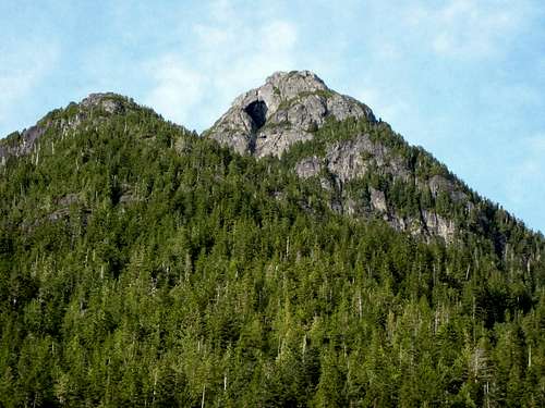 Arch from C15 Arch from C15 | 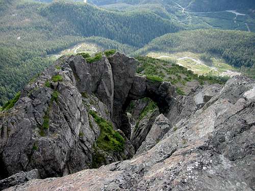 Arch from the summit Arch from the summit |
 Arch from high on C15 Arch from high on C15 | 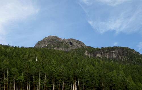 Arch from C15 Arch from C15 |
Weather
Nearest point current conditions and forecast.East
West
Additional Information
The map for this trip is the government 1:50 000 topographical map sheet 92-E/16, “Gold River”. Advance copies can be ordered on-line at this link. Copies are usually readily available in good bookstores and outdoor stores throughout the Island.Suggested Reading
Lindsay Elms, our local guru on all things obscure and hard-to-get-to on Vancouver Island, has written an excellent historical and geographical perspective of Conuma Peak on his Beyond Nootka website.Island Alpine – A Guide to The Mountains of Strathcona Park and Vancouver Island, Philip Stone, Wild Isle Publications, 2003, ISBN 0-9680766-5-3 and/or visit Island Alpine Climbing Guide
An excellent guide to the back roads of Vancouver Island is Backroad Mapbook. Volume III: Vancouver Island
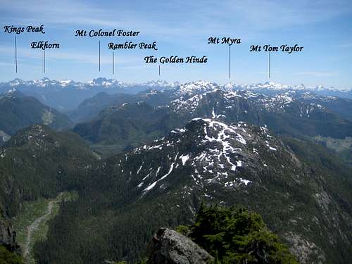
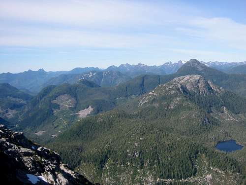
Strathcona Park Mountains from Conuma Peak.
Panorama
  |