
|
|
Trailhead |
|---|---|
|
|
40.60607°N / 110.4449°W |
|
|
Duchesne |
|
|
Summer |
|
|
10320 ft / 3146 m |
Overview
The Center Park Trailhead on the south slope of the Uinta Mountains of Utah is used to access Garfield Basin. Garfield Basin contains numerous scenic lakes including Doll, Superior, Five Point Lake, and Spider Lake. Garfield Basin is ringed with 7 peaks above 12000 feet. To the west lies Swasey Knob (12124), Bluebell Lake Peak (12260), Stone Benchmark (12707), South Porcupine Mountain (12729), and Porcupine Mountain (12892). At the far north end is 13060 foot Wilson and at the northeast end is East Wilson (12779).At the trailhead you will find a large parking area, an outhouse, and an information board. The trail to Garfield basin leaves just to the right of the information board.
 Garfield Basin. The background peaks are the Kings-Emmons ridge.
When to Visit
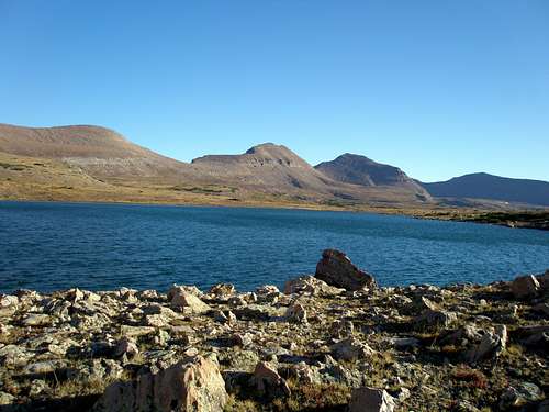
The trailhead is accessible in late spring, summer, and early fall. The best months are July, August, and September. One of the many small lakes in Garfield Basin
Driving Directions
From Duchesne Utah, turn north on route 87 (N40 9.806 W110 24.083). Follow route 87 north for about 15.6 miles until just after a hairpin turn where you turn left (N40 21.483 W110 23.310) on 21000 W and head for Mountain Home. Follow this road about 3.6 miles until it ends at a T intersection (N40 24.585 W110 23.329) and turn right.The road quickly bends left at a 90 degree angle and you again head north to (N40 27.893 W110 23.195) where the road to Moon Lake continues straight and you turn right onto a dirt road and cross the Lake Fork River. This turn is reached just shy of 4.5 miles.
Just shy of .5 miles later at N40 28.055 W110 22.746 take the second of two closely spaced lefts. Follow this road about 4.2 miles until you see the sign for Hells Canyon at N40 31.300 W110 21.350. Turn left up Hells Canyon Road. Go for about 7.4 miles and bear right at the intersection at N40 35.641 W110 25.673. Follow the road another .2 miles and bear left. Go 1.1 more miles until its end at the center park TH.
On the way back to Duchesne, the intersection with route 87 is not signed so you have to remember to turn right.
 Upper Garfield Basin
Road Conditions
I have seen a washout on the dirt road just after the Lake Fork River Crossing, but I was able to successfully navigate it with a Subaru Legacy and the washout has since been fixed.The two times I've driven the Hells Canyon Road it's been in great shape. It is narrow but there is always room to pull over for another vehicle. It is advertised as steep and rocky, but I found it neither, just a rather ordinary dirt road. I had no trouble whatsoever with the Subaru.
 Doll Lake
Camping
If instead of taking the turnoff to Hells Canyon, you continue straight along the road to the Swift Creek Trailhead you will encounter five campgrounds, Yellowstone, Bridge, Reservoir, Riverview, and Swift Creek. The closest is Yellowstone at 2.2 miles from the turnoff.Guidebooks
The book High Uinta Trails by Mel Davis and John Veranth provides driving directions to all major Uinta Trailheads as well as trail descriptions for all major trails.Map
 Topo map