
|
|
Route |
|---|---|
|
|
43.77420°N / 114.142°W |
|
|
Mountaineering |
|
|
Summer |
|
|
Most of a day |
|
|
5.6 (YDS) |
|
|
Overview
The summit of Goat Mountain via Wildhorse Basin can be reached with less than half the miles required on the standard route, but beware, Wildhorse Basin is Idaho on PCP. Most of the big peaks riding on the basin’s enormous cirque are guarded by a long and rarely broken system of crumbling cliff bands that, for the intrepid climber, requires some steep scrambling, route finding and a little luck. Once on the crest, the climbing usually gentles up considerably. Making it to the crest from Little Wildhorse lake requires a little bit more. This route is dangerous and not recommended. Most of it would be easily protected with rope and some gear but the exit is a veritable toilet bowl that regularly flushes loose rock and dirt, all but invisible to the unsuspecting below. The route from the lake follows the black line to the low point in the saddle. in late summer, the route only crosses two snow fields but an earlier season climb would probably require crampons.
Getting There
From Mackay: Take US Highway 93 16 miles north of Mackay to the Trail Creek Road. Turn left on the Trail Creek Road. Follow this road 18 miles to the Copper Basin Road. Turn left on the Copper Basin Road. Follow this road 2 miles to the Wildhorse Creek Road. Stay to the right on the Wildhorse Creek Road. Follow the Wildhorse Creek Road 5.5 miles to the campground. The road continues for another 3 miles up the canyon but you'll need a high clearance 4X4 vehicle to negotiate the numerous Idaho obstacles. The road forks near the end, stay on the right fork till it ends at the trailhead.From Sun Valley/Ketchum: Take Highway 75 (main street) to Sun Valley Road. Turn northeast onto the Sun Valley Road. This road turns into Trail Creek Road. Follow this road to the Copper Basin road. Turn right on the Copper Basin Road. Follow this road 2 miles to the Wildhorse Creek Road. Stay to the right on the Wildhorse Creek Road. Follow the Wildhorse Creek Road 5.5 miles to the campground.
Hike approximately 1.3 miles up the trail toward Howard Peak and then cut right on a very faint forest service trail. It’s been several years since the trail was maintained, keep an eye out for blazes and small rock cairns. Follow the trail until it peters out in a large meadow with 3 small lakes. Climb above the tree line toward the long water slide that spills out of Little Wildhorse lake.
 Howard peak from Little Wildhorse lake, the trail forks to the right near the base of this stand alone peak.
Route Description
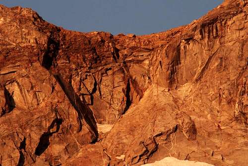 The Throat I shot this from camp with a 400mm lens.The route from the small snow patch stays to the right after the choke point near the bottom.
From the lake, ascend easy class two slopes shown in the photo. Hike up the the obvious open throat below the lowest point on the crest between Goat and Florians. Kick steps up the small 40 degree snow field to the base of the cliff. Follow the two inch crack until it ends, cross right onto the small arête and continue till it ends. Then cross back to the left and follow small holds that end below a large dirty shelf with a big loose looking block on the right side of the throat, squeeze between the block and shelf above it to easy ground and then onto the crest. From there, follow the standard route to the south and then true, north summit.
 Looking back at the exit (circled in blue) all of the objective dangers arent visible from below.
The Descent
If I’d had a rope, I would have done a double rappel back down the route, but a down climb was out of the question. Follow the crest south past Florians Nudl then drop down to the 11,00’ contour into the basin above Handwerk follow the contour below the cliffs and then regain the crest at the saddle above Big Wildhorse lake. Hike down to the lake and then back to the trail in the valley floor.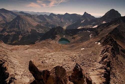 Big Wildhorse Lake from the summit of The Florians Nudl The descent crosses the low saddle above the lake on the far end of the ridge on the right.