
|
|
Route |
|---|---|
|
|
51.36500°N / 115.265°W |
|
|
Mountaineering |
|
|
Spring, Summer, Fall, Winter |
|
|
A long day |
|
|
5.4 (YDS) |
|
|
2 |
|
|
II |
|
|
Overview
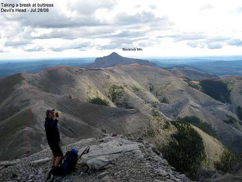
The South Gullies is a shorter approach route to Devil's Head which allows the climber/scrambler to join the middle of the West Ridge route at the Saddle in the West ridge. The access involves several river crossings and access by the Valley of the Birds or by the second drainage. The trip is a long day trip as it is 1150 m (3800 ft) and 16 km RT(~10 miles) on top of the long drive in and out.
Area Access
Devil’s Head may be in plain view of over a million people but is still remote by modern standards. The base of the mountain is guarded by a set of cliffs which limit access from several directions and the only road into the area is a poorly maintained commercial gravel road. The last part of the road is best accessed with a 4x4. The original route to the base of the mountain involved following the North Ghost river west past the south side of the mountain to Malamute valley and approaching the mountain from the west. The North Ghost valley has steep walls and five river crossing are required to access Malemute valley. The shortest current access involves three river crossing on foot and then scrambling up a steep side valley to reach the mountain from the SE.
The Devil’s Head area is part of the overall Ghost -Forest Land Use Zone (FLUZ) and the mountain is now in part of the Don Getty Wildland Park which is beside the Ghost River Wilderness Area and Banff National Park.
To access the Ghost area, travel west from Calgary to Cochrane. Take highway 1A west for about 13.5 km and then turn North onto to the Forestry Trunk Road which also called Highway 40 and Secondary Road 940. Follow it for about 22.7 km to a gated gravel road on the West side. The road is about 100 – 200 m past a major curve to the North and the turn off for Richards Road. The road has a large gate made from metal pipe and it is on the South side of the Bar Cee Ranch. Close the gate and watch your speed as there are free ranging cows in the summer.
The gravel road is used and maintained by several commercial companies but it is open to the public. It is rough and narrow in spots and crosses one poor bridge in various state of repair or drive through the stream on the North side. Stay on the main road for about 16.5 km to the Big Hill. There are views of Devil’s Head and the North and South Ghost valleys from a gassy parking area to the right of the road. The road down the hill is steep and can be heavily rutted and covered with large rounded river bed rock. In the winter if can be snow drifted or icy. If you are not driving a 4 x 4 it may be worth a walk and look to be sure you can get back up.
There are no services or phone reception out here. At the bottom of the hill there is an area to the left (South) where people camp. The trail to the left leads to Devil’s Gap and the South Ghost. The trail to the right leads haphazardly across the gravel flats and river bed to the North Ghost area. Ignore the turnoff to Black Rock mountain (interesting hike to an old abandoned fire lookout) and travel along a canal and over a bridge. Park near Sentinel Crag before the river crossing at the entrance to the mountains (Marker 39). There is an official government ban on crossing this river here or upstream of Marker 39 with vehicles to protect Brown Trout which spawn in the gravel beds of the river.
Route Access and Description
Overview of access routes. The Purple route is access for the South Gullies Route.
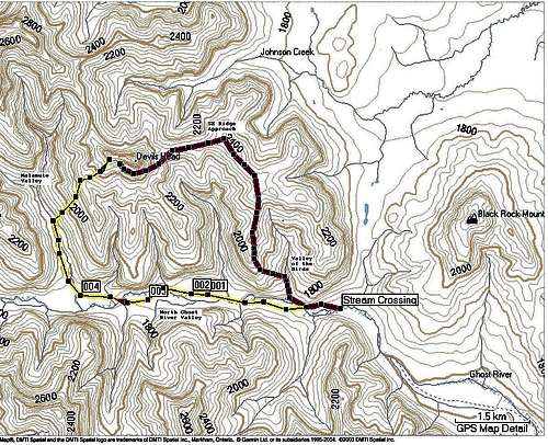
Park the vehicle at Marker 39 and cross the river several times. Enter the Valley of the Birds which is the first valley/canyon entrance on the right as you travel West in the North Ghost Valley.
Find a trail on the left hand side of the canyon which gains a long N-S ridge which leads to a West ridge which leads up to the East face of Devil's Head.
There is an alternate access in the second valley which would be more direct to Devil's Head but it is reported to be harder scrambling and has less traffic and trail. The route starts on the left hand side of the second valley drainage before the first waterfall.
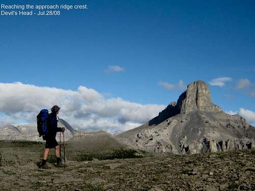
View of Devil's Head from ridge as top out. Photo courtesy of Abhi Maneriker.
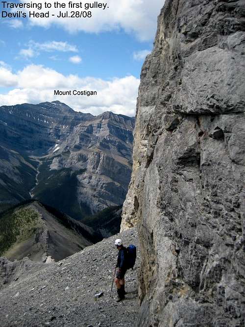
Route from base of East face. Photo courtesy of Abhi Maneriker.
Base of East Face. Photo courtesy of Abhi Maneriker.
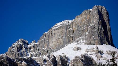
Southside of Devils's Head. Photo courtesy of Jason Wilcox.
Note pillar on right hand side of the start of route.
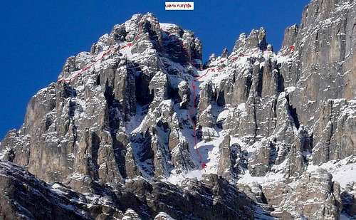
Closeup of Gully route in winter. Photo courtesy of Jason Wilcox.
Note pillar on climbers right hand side of the start of route.
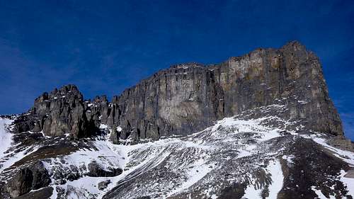
South side from further West. Shows gullies are not as steep as previous pictures. Photo courtesy of Jason Wilcox.
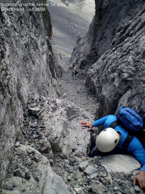
Scrambling in South Gullies. Photo courtesy of Phil Scheiner.
Lokking down gullies from Saddle on West ridge. Note pillar on climbers right hand side of the start of route.
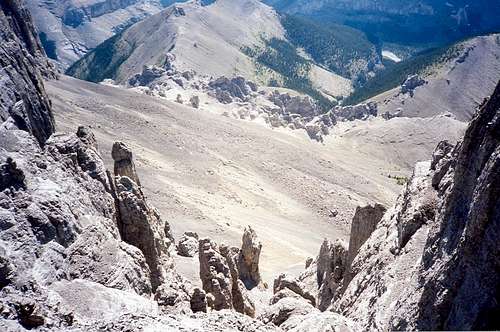
The South Gullies route joins the West Ridge route at the Saddle on the West ridge.
Move 70 m right across the rubble on ledges to a gully the leads up to the saddle between the isolated pinnacle and the main ridge. Go over the saddle between the Devils Horns(cairn) and across ledges down and up to a gully up to left that leads to base of two chimney systems.
Looking up at chimneys on Main Summit from the base of Pinnacles in the Saddle.

The Right hand chimney has a partly overhanging chockstone at 4 -5 m but it is the one because you can see a chained rappel station up on the right-hand wall above the chockstone. Climb the chockstone directly ( long reach, partly overhung and poor footholds) or climb the left groove/chimney for 4-5 m and then traversed right on face on better footholds around to above chockstone in main chimney.(5.3/5.4 and no protection- first crux)


More crux pics at https://www.billkerr.ca/index.php/devils-head-crux-climb-scramble-ghost-area-don-getty-wilderness/
Rappelling back over the chockstone. Photo courtesy of Phil Schreiner.

Climb up main chimney for 30 m to where chimney splits. A Left chimney leads up to very exposed face climbing ( old sling) but better to continue up right one Main Chimney which leads to the same large sloping rubble ledge.
Climbing in the upper part of the main chimney. Photo courtesy of Abhi Maneriker.

There was a cairn which was marked with flagging tape to mark the top of this chimney for descent later.
Angle up right 70 – 100 m up to base of next wall which has climb/scramble options that lead up to the narrow ridge on the left but we moved right along base of the wall past a small pinnacle and around for 30 m to an easier spot on the wall. Face climb the wall 5.3 (second crux) angling up left for 10 m to a ledge.
Rapelling the slabby wall. Photo courtesy of Phil Schreiner.

This is also marked with a cairn as it is hard to see where to start down climbing on the way down. Move right and up a loose gully which goes left then right and up onto easier ground which is the summit ridge (cairn).
Walk 200m to the summit cairn and enjoy the view which includes the Calgary office buildings on the horizon.
Downclimb everything except the lower part of the chockstone chimney (short rap) or downclimb the groove beside the crux. Then climb up west ridge and rap off it or downclimb the South Gullies route.
Essential Gear
Helmet is essential. May want alpine climbing gear with a small rack - hard to protect except around the two crux spots due to loose rock.