
|
|
Route |
|---|---|
|
|
45.06964°N / 110.77703°W |
|
|
Hiking, Scrambling, Skiing |
|
|
Spring, Summer, Fall, Winter |
|
|
One to two days |
|
|
Class 3 |
|
|
Strenuous |
|
|
Overview
 Saddle to East Summit
Starting elevation: 5200’
Peak elevation: 10,969’
Difference: 5,769’
Total Miles: ~20.00 miles
Total Est. Time: 9-12 hours (single day)
Beattie Gulch is an alternate route to Electric Peak which starts at around 5,200 ft (only about 40 feet above the Yellowstone River). The route essentially follows a massive north flank of Electric all the way to its west summit. Elevation difference is about 5,769' with total elevation gain well over 6,000'(!). The entire trip is right around 20 miles, with few maintained or marked trails for the last portion. Be prepared for leg punishment, even the first portion will brutalize the quads with the bike. Drink plenty of water. In late June, it took us about seven hours to summit, and then three hours out back to the car.
 Elevation Profile
Getting There
 Trailhead
Start at Corwin Springs, 8 miles north of Gardiner (Park entrance) on Highway 89. Cross the bridge over the Yellowstone River. Drive south on the washboard dirt road for around 3.5 miles. On the west you will drive past Devils Slide, and shortly after there will be a sign for the Beattie Gulch trailhead.
Route Description
 Topo of route; red is biking, blue is hiking
 From summit
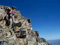 Saddle
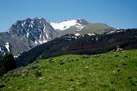
 Burned forest
The easiest way to describe the route is by breaking it up into three sections...
The first portion of the route follows an old access road that switchbacks numerous times and maintains a steady grade past an old homestead and eventually winds up near some Forest Service cabins (as well as a private, gated one to the east). The old road climbs up about 2,600' feet, skirting to the edge of the Yellowstone Park boundary and it eventually peters out in an old burned section of forest about 0.4 miles east of Little Joe Lake. Up to this point, a mountain bike is very helpful making good time up (and later, down) the access road... although it will start to take its toll on the legs, especially with a pack on. When you hit the burned forest, there is entirely too much deadfall to bike any further (in addition to the unmarked park boundary here)... the fun begins.
At this point, start wandering southeast which will push towards the small bluffs on the flank that will be followed for most of the approach. The trail is not well defined (typical Montana trail) but there will be several posts along the way. The trail threads through forest and becomes hard to discern through several hillside meadows. At several spots, there will be openings on knolls with views of Electric. Stay along the east edge of the ridge and you should be able to catch the ‘trail’ on and off. Following this trail about 1.75 miles will get you situated on a rocky knoll. At this point, most all of the remaining route is visible, although very little is a trail of any kind. From this knob, Electric is still over 2 miles away as the crow flies, to give you some scale as to how massive this mountain really is. Drop down to the small saddle and basically follow the huge grassy slopes to the base of the west summit / talus field.
Depending on the snow situation and time of the year, there are a few options from here. If the hiking group is equipped with equipment and they feel comfortable with the avy conditions and the runout below, a traverse across the north-aspect bowl could be made to the base of the east (highest) summit to begin the final scramble (obviously not the same issue at the end of summer). Otherwise, elect to skirt the remnants of the snow field and traverse across the saddle between the east and west summits. The south side of the saddle will likely be completely devoid of snow. The saddle crest proved to be the easiest route across, with small sections of fun scrambling. The final push to the east summit looks much more intimidating than it really is. Once you start up and do some scrambling and traversing it won’t take long to summit out. Keep in mind that this is very rotten, loose rock… Check any foot or handholds well before weighting them, and use a little extra caution, especially directly above or below someone else. Descend off the summit in a similar fashion. Glissading the north bowl may be an option on the way out, and be sure to look around for the goats!
Essential Gear
A good mountain bike will help speed up the first several miles of monotonous road, which would not be much fun to hike. It's a great way to finish up a long day of hiking as well, with a nice long downhill.Supportive shoes for the talus and loose rock are important. Bring at least 3-4 liters of water and a small filter, bug spray, lightweight rainshell, sunscreen, topo quad(s) and plenty of high-energy snacks. Ice axe, helmet, boots and gaiters would be wise for crossing the snowfields as well. Don't forget the bearspray either.
As a note, I believe there is cell phone service near the summit, if needed for an emergency, etc.