
-
 2126 Hits
-
 75.81% Score
-
 6 Votes
|
|
Route |
|---|---|
|
|
39.07320°N / 105.3908°W |
|
|
Hiking |
|
|
Spring, Summer, Fall, Winter |
|
|
Less than two hours |
|
|
Easy Class 2 off-trail walk-up |
|
|
Overview
 Summit register and marker
This short, pleasant route to a rocky overlook with leave plenty of time in your day for summitting other nearby peaks, dangling a fly for some fish or pondering the charred hell of the Hayman burn area. This route leverages 4x4 roads that, as of the time of this writing, are in decent shape. Then the route ascends up the gentle west ridge of Tappan Mountain to the summit.
Roundtrip Mileage: ½ mile round-trip from 4x4 parking
Elevation Gain: 215 feet from 4x4 parking
Getting There
From Hwy 24 in Lake George- Drive north on Park County Rd. 77 for About 4.5 miles.
- Turn right (due north) on FS 210. You may see a small wooden sign reading “Platt Springs Road #210. Do take special care to turn down this road and not down the parallel road to your right/east. The “Trespassers will be shot; survivors will be shot again” sign a few feet down the driveway may serve as indication to the observant that they are in the wrong place.
- Follow FS 210 for .3 miles.
- Turn left on FS 292 and follow this for .5 miles.
- Turn left on FS 292A and follow this for about .5 miles.
 Park just below the crest of the ridge
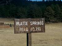 Handpainted Road Sign
Parking: This narrow but relatively smooth road has very little parking once you reach the Western Ridge of Tappan mountain. However, continue past the high point of the road toward a wooden power line tower. (Note that this power line cut does not appear on any maps of this area that I have, hard-copy of digital, and appears to be new, from the post-Hayman fire era.) Just below the crest of the Western Ridge of Tappan Mountain is a pullout that could fit 2-3 4x4s if parked strategically.
A special note on these 4x4 roads: These roads mentioned in “Getting There” are not particularly rough; they have some rutting and a few rocks, but are suitable for any stock 4-wheel drives. Be cautious, however, of falling trees as you drive through the burn area. After my ascent of Tappan Mountain, I was returning toward FS 210 on FS 292 when I encountered a tree blocking the road. I clearly recalled the tree was not there on my way in, and the fresh disturbed root area confirmed this suspicion. Fortunately, I was able to leverage the tree out of my way (I was alone) but as there was no way around this fallen tree (forest on both sides) I could have had an interesting time getting out of this area if I had not been able to shove the tree out of my truck’s path.
Route Description
- Leave your vehicle under the power line and backtrack on the road to the toe of the west slope.
- Begin heading east-northeast up the slope through sparse trees and bushes. The grade is moderate and the Hayman Fire burned away much of the underbrush, making for very easy going.
- The summit boulders will gradually come into view, complete with a summit jar and a mess of barbed wire and old fence posts.
- After taking in the distant views of Pikes Peak and close-up views of the scorched Pilot Peak, backtrack west-southwest down the slope to return to your truck.
Essential Gear
- Trail map (Trails Illustrated #137 (Pikes Peak, Cañon City) would meet most needs)
- Compass
- Comfortable hiking boots or walking shoes
- Snowshoes after a heavy snowfall
- Water and snacks
- A camera to save memories of the high country views
- First aid kit
- Other standard backcountry essentials