
|
|
Mountain/Rock |
|---|---|
|
|
45.93742°N / 115.10513°W |
|
|
Idaho |
|
|
Mixed |
|
|
Summer, Fall |
|
|
7660 ft / 2335 m |
|
|
Overview
 Rocky Peak from the summit of Indian Peak.
 Ridge crest
 Summit area
 East side
 South side of summit
 North ridge from west
 Summit rocks
 South ridge
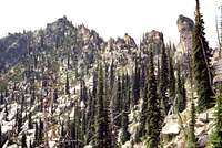
Rocky Peak is the most rugged summit in the 300 square mile Meadow Creek drainage, which after Moose Creek is the largest tributary to the Selway River. Though it’s not the highest in its group of the central Clearwater Mountains its layers of granite blocks stacked up ever higher to a teetering appearance is an impressive sight. Nestled amid these rocks is a tangle of subalpine fir and high elevations shrubs that give the mountain the appearance of a pyramidal rock garden. It is located just south of the designated wilderness boundary, but still is one of the more remote and difficult places to reach in north central Idaho. The least difficult routes to this mountain enter the wilderness, the leave it again. The approaches entirely out of the wilderness are much longer and more difficult than those within. The higher peaks in this area are formed of unusually decomposed granite that gives the ground a white powder texture with very little soil development. The upper elevations of Rocky Peak are somewhat of an exception to this as the rock seems to be fairly solid, but the subalpine beach feel is still well developed on the connecting ridges and mid-elevation slopes on the east side. The 7,660 foot mountain has 440 feet of prominence.
The summit area is formed by a dome with a very steep north and west aspect. The west side forms a steep rise 1,600 feet above Snowslide Creek and is covered with tangled, stunted trees between the rocks and cliffs. The south ridge is broad and gentle providing the only easy terrain on the mountain at any elevation. It gently extends south before dropping 3,400 feet into lower Schwar Creek. Rugged spires and cliffs on east spur ridges separate the north, east and southeast basins that fall 2,300 feet into Schwar Creek. These basins are very steep mosaic of boulders, cliffs and loose scree and granite powder that are very difficult to navigate. The actual top is the top rock on a pile of huge, smooth boulders on the summit that provide difficulty in reaching the true high point. One huge boulder on the west flank of the summit forms a huge gap underneath creating a cave like space the size of a very large room. The highlight of the mountain is the north ridge that is formed by a long series of giant boulders precariously staked up on edge.
The mountain provides good views across Schwar Creek to the large masses of Bilk Mountain and Elk Mountain. The view west is dominated by the picturesque form of Vermilion Peak in front of the endless waves of smaller tree covered mountains and ridges stretching to the horizon. To the northwest across the glacially carved Snowslide Creek basin the Copper Buttes and Indian Hill above the Selway River can be seen. Looking north down the ridge the dramatic palisades of granite, clothed black by lichens stretch to the less dramatic south side of Indian Peak. Beautiful close up views are provided by the hot pink wildflower, Idaho Douglasia, which along with the Elk Mountain area to the east, supports the largest extended population of this endemic on the planet. This stunning species was only described by botanists in the early 1980s.
The primitive road into this area passes between the Selway Bitterroot Wilderness and the large Meadow Creek roadless area. Meadow Creek is managed much as a wilderness area, but some motorized vehicle access is allowed on some trails. The area is becoming controversial as different factions argue for their interest in the area. Many would like to see it designated wilderness, however it was excluded from designation as part of the compromise to create the massive Frank Church River of No Return Wilderness to the south. Some would like to see it managed for timber and other resources as intended when it was excluded from designation. Despite its planning history, it is doubtful the Forest Service would enter the basin for timber purposes, but it will likely never be managed fully as wilderness. In the fall, hunters are common in the area with many four-wheelers on the road and stockmen on the trails; however Rocky Peak is remote enough that few if any hunters will be seen during hunting season. Still use caution during this time and wear orange. There are a lot of wolves in the area so seriously consider leaving the dogs home if you don’t want to lose them.
Getting There
 Starting on the north ridge of Rocky Peak.
Via the South Fork Clearwater
 North Ridge
 On the north ridge
 Opening to ridge
 Typical terrain
 Looking north
From Highway 95, turn east into Grangeville and continue on main street (Highway 13) for a long mile to the east edge of town. Town ends abruptly at the intersection of Highway 13 and the Mt. Idaho Grade road. From this intersection turn south (right) on the Mt. Idaho Grade road. After driving approximately 0.7 miles take the curve to the left at the drive-in theater (the curve is the main road). Continue on through the cluster of houses known as Mt. Idaho and soon the road will descend into the deep canyon of the South Fork of the Clearwater River. The road hits the canyon bottom and Highway 14 joins from the left, 9 miles after the theater curve.
At the bottom of the grade continue straight for 38 miles to the Red River Road. Turn right and continue up Red River for about 14 more miles to Red River Ranger Station. Turn right (keeping on the pavement) and go through the Ranger Station for 0.4 mile to the Montana Road, Forest Service Road 468 (also known as the Magruder Road or the Nez Perce Trail Road). Turn left off the pavement on this road and continue 19 miles to the junction of road 285 to Green Mountain. Turn left on road 285 and continue 15 miles to the trailhead just south of Elk Mountain.
From the trailhead take trail 517 north over Elk and Bilk mountains and continue west across the Schwar/Marten divide to Grave Meadow. This is a distance of about seven miles. Next get onto the high ridge to the west. There are many ways to do this. It is possible to go straight up the steep slope west of the meadow or follow the trail north from of the meadow and get onto the ridge at the saddle. Hike out the ridge to the south and pass over the rounded high point of Indian Peak. Then continue on the broad ridge toward Rocky Peak. Eventually the ridge will become a jagged jumble of huge granite boulders that cannot be negotiated. The west side of the ridge is mostly too steep, but below the rock pillars and palisades on the east side there is a run that allows for pretty easy cross country hiking. Look ahead to keep on a good line and you are not likely to find yourself at many dead ends.
Near the summit pyramid there three chutes up through the impassable rocks. The light tan colored one that reaches the summit to the left of the summit point should be avoided. It is very steep and full of loose soil making an ascent very difficult. There are two others cutting up the mountain and reaching the shoulder to the right of the high point. The one on the left is better because the one on the right will put you into some ugly cliffs and impassable rocks on the west side. Follow this chute to the ridge top. There will be brush to pull through and rocks to lift one up over, but it’s not very difficult. Pass through the notch on the ridge to the west side and contour around the slope toward the summit. This area is very steep but there are good holds on the brush and small trees. Near the top a huge boulder laying on others has formed a cave like space that you will pass through or go around to the right. Once beyond it hike up the last rise on the south aspect to the summit. There may also be another scramble route just right of the center of the north face, but it is very steep and brushy. The mountain is about three miles of cross county hiking and scrambling from the Grave Meadow area.
There likely is another route on the 517 trail that drops into Spook Creek just before the Elk Mountain trailhead. This trail ties in with the 513 trail in lower Schwar Creek about four miles in. It may be possible to leave the trail here and climb one of the ridges up the south side of Vermilion Peak and then follow the gentle ridge east and then north to Rocky Peak. But no first hand information of such a route is given here. While studying a map, it may be tempting to leave the trail in the Elk Mountain area and drop down into Schwar Creek and go up the east side of Rocky Peak. Schwar Creek is wide, deep and brushy and a cross country crossing is not recommended.
Caution should be taken on much of driving portion of this approach. For several miles on Highway 14 just east of the base of Mount Idaho Grade, the road is very narrow and twisted. Watch the speed and stay on the right side of the road and hope the oncoming traffic (largely composed of RVs and logging trucks) does as well. The shoulder is falling into the river on this already narrow road and in some places even the white strip is going, leaving absolutely no space between you and the river. On the mountainous portion, the 285 road is very narrow and will take some time to navigate safely. Road use can be high some weekends and during hunting season so anticipate other vehicles on the corners.
Part of the adventure of going into this part of Idaho is driving along the South Fork Clearwater River. This small, but beautiful river has a steep grade over endless boulders of class III, IV, and V whitewater in the spring. About 10-15 miles upstream the canyon tightens into a spectacular gorge with miles of technical climbing that is never climbed. Low elevation mountain goats are not an uncommon site here on large granite walls. All is especially beautiful in the fall when the larch and broadleaf trees lining the rocky stream turn gold. The river also supports good runs of steelhead and Chinook salmon, which can be seen jumping some of the small waterfalls during the appropriate season.
 Rocky Peak and Snowslide Basin.
Via the Selway River
 West side
 South ridge
 Summit
From Kooskia follow Highway 12 east for about 20 minutes to Lowell at the confluence of the Lochsa and Selway Rivers. Turn right onto the Selway Road and continue for about 14 miles to the right turn across the river and go up Meadow Creek. After crossing the bridge it is about two miles to the left turn over Meadow Creek. Cross the creek and turn left and continue about 12 miles up the road to the trailhead on the south end of the Indian Hill summit area. There are many parking places and open sites to camp if desired.
From the trailhead take the 602 trail east toward the Copper Buttes. There is a trail junction visible from the trailhead; keep to the right. Follow this trail for about nine miles to Drake Saddle. Through much of the way the trail passes through severely burned forest that was cooked by the 17,000 acres Drake Fire of 2007. From Drake Saddle there are a couple ways to go. Continue left on the 602 for about seven miles to the Grave Meadow area and then get on the ridge north of Rocky Peak as described above or turn right on the 628 and drop into Drake Creek. After a long mile take a left on the 609 and go up Buck Lake Creek. After a mile or so this trail will climb up to the ridge coming off the west side of Indian Peak. Turn east and hike cross country a little over a mile to the top of Indian Peak. Then follow the ridge south toward Rocky Peak as described above. This is probably the easiest way from the west, with a distance of about 14 miles.
A note on the roads from the west: the Selway River Road is paved for the first few miles and then it becomes gravel and is much narrower. Traffic can be heavy and some corners are tight so drive this road with caution. The road up Indian Hill is especially narrow and steep in places and isn’t suitable for the family sedan. Many people like to drive this road up to the lookout on the summit so proceed with caution. The fire that burned the forest on Indian Hill was the Slims Fire in 2003, which burned about 12,500 acres.
Disclaimer: I have seen the trail as far as Little Copper Butte and have been told its good to Drake Saddle. I have also seen the trail in the vicinity of the ridge coming off the west side of Indian Peak. But I have no other first hand information of the trails from the west. If coming from this direction be sure to check current maps and don’t trust the USGS quads as many trails have been moved or no longer exist. Contact the Forest Service offices below for information.
Red Tape
None, other than standard wilderness regulations when within the Selway Bitterroot Wilderness boundary. Given the overall remoteness and connectivity of the roadless areas, it all is generally managed and treated as a wilderness area.Camping
 Grave Meadow
There are not a lot of good camping opportunities near Rocky Peak. It is possible to camp near the trailhead on Elk Mountain, but this does not get one close to the peak. Backpackers can find camping in the east or north basins of Bilk Mountain where there are meadows with good water sources, but these also are not real close. Grave Meadow at the north end of Indian Ridge is about a seven mile hike from the trailhead and is less than a three mile cross country hike to Rocky. About a mile further north, Red Lake is also a camping option. If coming in from the Indian Hill trailhead to the west, there are probably camping options in the stream bottoms or the lakes near Drake Saddle. This is a longer hike and Rocky Peak is still an indirect hike of several miles. Also some of the trails in this area may be suspect and do not occur as indicated on the map (or not at all). To reach this mountain it may be necessary to camp at the trailheads or other campgrounds along the Montana Road or Selway River and plan at least one or two nights out.
When To Climb
 Snowslide Basin
Obviously the summer is the best time to reach this summit. Winter access into this area would be extremely difficult due to terrain, lack of a workable route and deep snows. At this high elevation come prepared for any kind of weather regardless of the time of year, even on days that seem warm in the morning. Storms can and often do blow up out of nowhere and can drop temperatures dramatically and bring rain or snow. It may be possible to snowmobile along the 285 road toward Elk Mountain, but it’s a long way to that trailhead from the accessible ends of the road and it doesn’t really get one near Rocky Peak or its neighbors. Crossing the steep, wide, deep and brush tangled Schwar Canyon would be a challenge in the summer, but not really possible in the winter.
More Information and Current Conditions
 Below the west side of the north ridge.
Go to the mountain prepared for variable conditions. Rocky Peak and its neighbors are not easily accessible, which adds a degree of difficulty to any trip into such remote country. The ability to communicate with the outside world or summon assistance if needed is greatly impaired. Any trip in this area should involve caution and good planning.
Before traveling the 468 or 285 roads or for more information and current conditions in the Rocky Peak vicinity, contact the Nez Perce National Forest or the Red River (Elk City) Ranger Station. If coming in on the trails from the north or west contact the Moose Creek Ranger District at the Fenn Ranger Station.
 Looking south
Nez Perce National Forest
104 Airport Road
Grangeville, ID 83530
208-983-1950
Red River Ranger District:
Elk City Ranger Station
300 American River Road
Elk City, ID 83525
208-842-2245
Moose Creek Ranger District
831 Selway Road
Kooskia, ID 83539
208-926-4258
NOAA Forecast