
|
|
Route |
|---|---|
|
|
46.87371°N / 10.08760°E |
|
|
Mountaineering |
|
|
Summer, Fall |
|
|
Most of a day |
|
|
Short scrambles |
|
|
I |
|
|
Overview
This route can be considered as the normal route of Urkundkolm. It's basically an uphill hike on good paths and a wide track (up to three hours - depending on your backpack load) between the village of Vent and the Breslauerhütte, and after that it gets a little bit more demanding: the path turns out to narrow a lot, calls for all your attention in order not to miss it and offers some short steps with steep scree where you might need to use your hands. No climbing involved, though, but simple hikers without any experience in high mountain terrain should never go alone after the buildings of the Breslauerhütte.Getting There
Take a look at the main page in order to know how to reach Vent. It's (almost) all there, but I'll gladly include any additional information you can provide...Route Description

Enter the village of Vent from the road, walk by the church and keep going along the main street until you find the cables of a chairlift across it. They lead to your right, uphill, and under them a wide path is easily found. Take that path. It winds uphill, turning around several avalanche barriers without any possibility of your missing it. It always follows the chairlift, up to its upper station at Stablein Alm. That's a small flat area on the slopes of the mountain, with the chairlift station and a small restaurant (I'm not strictly sure about this, it was closed when I visited the place).
North-west (meaning simply "uphill") of the chairlift station you will find the beginning of a wide dirt track that leads grossly east. It goes uphill, but without violent slopes, along the southern flank of Wildes Mannle towards the small Rofenkar river (under the Rofenkarferner glacier and already in sight of the Breslauer Hütte buildings) . You will find a metallic bridge to cross the river. On its west bank the dirt track is still wide, but it's got a more violent slope and will lead you directly to the Breslauerhütte. From the moment you leave Vent you will have been walking for about three hours.
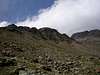
Once you stand at the hut terrasse most of the altitude gain will be behind you. Scarcely an additional 290 meters shall be left to climb towards the summit of Urkundkolm. Leave the hut following the signpost to "Wildspitze". The path is good, rather wide at the beginning. Some 10-15 minutes after leaving the hut you will find another signpost, close to a memorial picture of a deceased mountain guide. That signpost clearly marks to your right a small narrow path towards "Urkundkolm". Take that path. As I said before, it's narrow and can turn rather steep. You will also find some loose scree slopes, and some short pitches could require you to look for an additional support placing your hands on the rocks. But this is not a climbing route. Simply be careful, walk slowly and be sensible. An additional (approx.) 45 minutes will put you on the summit of Urkundkolm.
Information by dmiki(March 2010):
In winter conditions, just after crossing the small bridge over the Rotenkarferner river it might be a good idea to loop left before heading up the ridge and towards the hut. Otherwise, the terrain under the hut can be rather avalanche prone.
 |
 |
 |
 |
 |
 |
 |
 |
 |
Essential Gear

No matter how easy the hike to the Hut can look: this is a three-thousand meter peak in the austrian alps and deserves to be treated as such. All usual high-mountain equipment should be required. Good boots, warm clothes, water, food must be carried anytime. Walking poles can be real handy, and full winter equipment (gaiters, crampons, ice axe) are compulsory whenever the mountain is covered by snow.