-
 4372 Hits
-
 75.81% Score
-
 6 Votes
|
|
Custom Object |
|---|---|
|
|
36.31513°N / 134.29688°W |
|
|
Custom object |
http://upload.wikimedia.org/wikipedia/commons/f/f9/MontagnePel%C3%A9eMartinique_1.jpg
This is a dormant page that I mostly use to create body sections that I cut and paste into regular mountain pages. Some items on page are just experiments. Please ignore.
[url=http://www.wildaboutbritain.co.uk/pictures/showphoto.php/photo/84834][img]http://www.wildaboutbritain.co.uk/pictures/data/14/medium/Sugarloaf_.jpg[/img][/url]
[url=http://www.wildaboutbritain.co.uk/pictures/showphoto.php/photo/84834][img]http://www.wildaboutbritain.co.uk/pictures/data/14/thumbs/Sugarloaf_.jpg[/img][/url]


The Hike
https://www.bing.com/maps/?v=2&cp=51.85670540145554~-3.055540909533654&lvl=14&dir=0&sty=r&app=60236~1~a
table fixing
|
|


|
|
Bird
leftover
Heimaklettur
RouteStrákar
J
Links: Letter with historical information from Brig. General Bruce Staser, son of Harry Staser.Chugach National Forest Brochure
Routes Overview
Deuxième Refuge.
Aileron Route
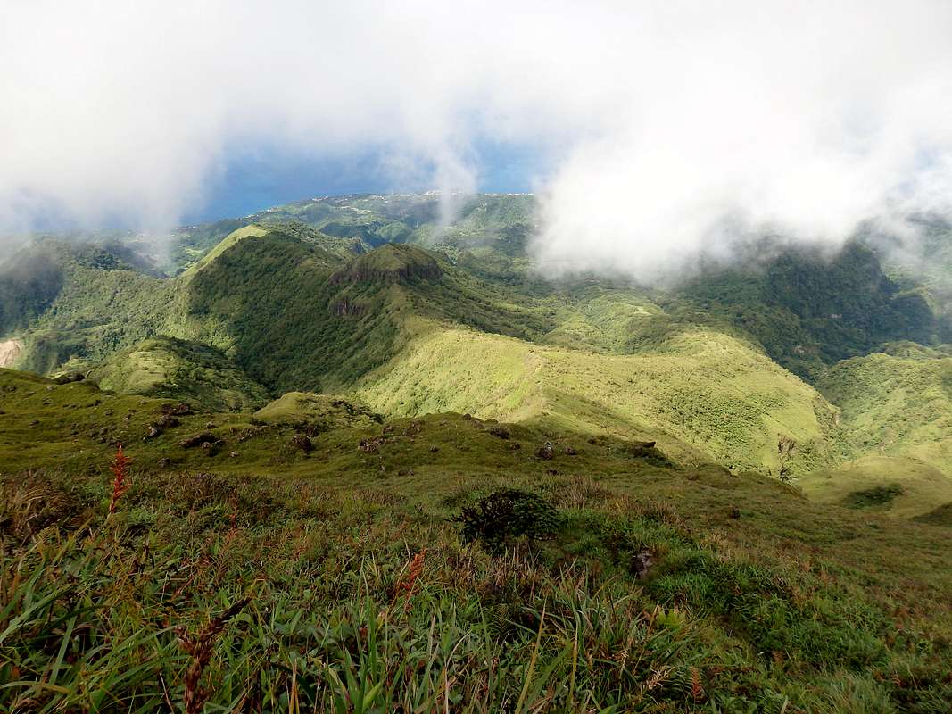
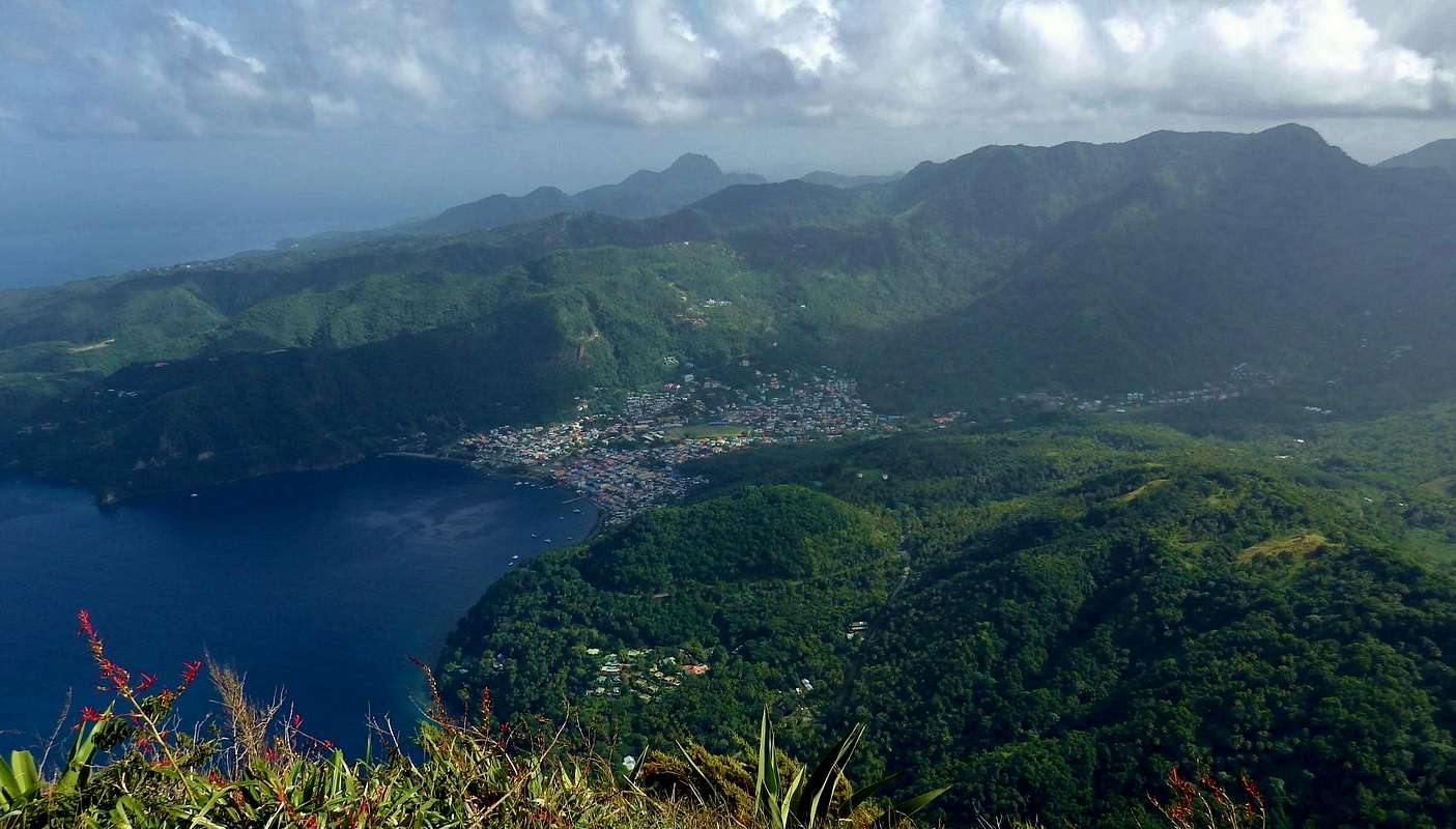
The Aileron Route is the standard route up Pelée. It gets a lot of traffic during the middle of the day, but it's pretty much deserted at dawn. And you should go at dawn.As a matter of fact, you should go before dawn. Here on the east side of Pelée, as well as on the summit cones, is the domain of the clouds--dark, dense, wet clouds, day after day after day. If you don't believe me, play the last 30 days of midday images from one of the Pelée webcams. This mountain is a cloud magnet, and the east side is the cloudiest side of a cloudy mountain. That said, if you leave the Aileron trailhead at 5 a.m., the odds are good that you'll beat the clouds, emerging at some point during your ascent into magical, clear views ... which might persist for an hour or two after dawn. Go for it. You can sleep in the afternoon, after you get down.
|
|


Grande Savane Route
|
|


A route with a tiny fraction of the usage of the Aileron Trail is the ascent of Pelée's west flank via "La Grande Savane" (the great savanna). This is a beeline route that doesn't have the scenic variation or interest of the Aileron, but it's not a bad choice for people who are getting a late start. This is because the west side is drier and less apt to be socked in by cloud, meaning you're likely to get at least some views on your way up, even if you don't get any on the summit.
The crux of the Grande Savane route is getting there. Drive north from Saint-Pierre on the D10 toward the village of Le Prêcheur. On the south end of that village, there is a signposted right turnoff for Pelée. Go straight up this, with no turns, till it dead-ends at trailhead parking, where there is space for a few vehicles. The 2000-foot climb up this single-track, overgrown, potholed road is extremely steep. I've done it (barely) in a rental Clio, but I left quite a bit of burned rubber and maybe a few bits of the undercarriage along the way.
The Grande Savane trailhead is at about 670 meters, leaving you 730 to ascend to the top, but since it lacks the ups and downs of the Aileron route, it may not be much more effort overall compared with that trail. The first 70 meters/200 vertical feet are in a pretty fern forest; after that, you're out in the wide open "savane," and this can be a blazing hot climb (don't forget the sunscreen). The path goes straight up through the tall grass, with an ascent grade of 25-35 percent. At 1155 meters, where it intersects the caldera trail near an automated weather station, you'll need to pay attention; the continuation of the trail eastward and upward toward the Troisième Refuge is a little hard to spot among the rocks and vegetation. Just remember that this path is direct--you need to look straight up.
The Grande Savane trail ends at the ruined Troisième Refuge, just below the Cône de 1902. Proceed from there as discussed in the Aileron Trail section.
For a map of the route, click here.
dia
|
|


History

(Photo: Tempest Anderson, 1902, public domain)
Maps
|
|


PP
 Petit Piton seen from the North Summit of Gros Piton
A lot of nonsense is circulated about Petit Piton. Many a Saint Lucian spins an elaborate tale about how Petit Piton is higher than Gros Piton--that Gros Piton is so named only because it is fatter, but not higher, and so forth. But the truth--as anyone who has climbed both will attest--is that Petit Piton is the smaller peak, distinguished not by its size but by the precipitous angle of its slopes on every side.
Should you try this climb? Maybe not. Frankly, if I were climbing just one peak on Saint Lucia, I'd pick Gros Piton--you get to start from the wonderful village of Fond Gens Libre and make your way to a higher summit after passing through a zone of stunningly gorgeous rain forest, an experience mostly absent on drier Petit Piton. Moreover, where Gros Piton is a steep hike, Petit Piton is a scramble, and not such an easy or safe one at that. If you miss your footing on the damp rocks near the summit at the wrong time, it's a long, long way to the ocean below. People with a fear of heights should skip it, and--because of a squeeze chimney on the route--so should people who struggle with their waistline.
If this hasn't dissuaded you, read on.
Getting There
Petit Piton is located two kilometers south of the pretty town of Soufrière on Saint Lucia's west (Caribbean) coast. By rental car or taxi, it's about 45 minutes north of the big airport at Vieux Fort, and a good hour and a half over the tortuous but spectacular road from Castries, the capital.
Beyond that, I'm not going to tell you how to get there. Every page I've published on Summitpost celebrates do-it-yourself, guideless hiking and mountaineering, but this one is an exception. You should get a guide for Petit Piton. Here's why:
-- There's just one viable route, and it starts on private land that you don't have permission to cross.
-- The trail to the upper mountain is maintained by the guides.
-- Near the top, you will almost certainly use the fixed ropes, at least for security. These are placed and maintained by the guides.
How to Get a Guide
For trained guides and the best rate, make arrangements through the guides cooperative in Fond Gens Libre:
Gros Piton Tour Guides Association Office
Fond Gens Libre
Saint Lucia
(open 8 a.m. - 3 p.m. daily)
758-459-9748
An especially good guide from Fond Gens Libre is Cameron Vauroque (758-286-9371).
Many hotels will also arrange a guide, usually with an unstated markup of at least 100%.
Route
 North from the balcony
From the hidden trailhead somewhere on the access road to Sugar Beach Resort, the route up Petit Piton starts as a trail climbing steeply through dry forest. The path crosses the north face before bending around to a balcony--a kind of rocky fin--high on the seaward western side of the peak.
 In the rabbit hole
From the balcony, the top is only a few hundred feet above, but the going is more challenging. There are three short YDS class 4 sections. The first is a short face with some real exposure (although greenery hides the extent of the drop, so it doesn't feel as scary as it might). The holds are big but they tend to be slimy. A knotted fixed rope can provide extra security, but I have seen one person take an alarming swing while dangling from the rope by one arm. The second crux is a low-angled chimney without exposure; it's awkward, and it involves a mid-fifth class move or two unless you use the fixed rope to muscle up it. The third crux, with minor exposure, is called the "rabbit hole;" it is likewise awkward but goes pretty easily with or without the rope.
The summit of Petit Piton is everything you could hope for, with a miniature grassy meadow to flop in while you admire ocean and mountain views in every direction. If they're not enfolded by storm clouds, all the major peaks of Saint Lucia are visible, the close-up view of Gros Piton being especially impressive.
|
|


Camping and Lodging
Camping on or near the mountain is not practical. Good nearby lodging includes La Haut Plantation (about US $150 double B&B; awesome views of the Pitons); Crystals (quirky, unique, and a little more expensive; even better mountain views); and Fond Doux (restored cottages 1 km east of Petit Piton). For relatively budget accommodation (about US $75) there is the Downtown Hotel in Soufrière, and Mango Splash (located on the beach about 15 km south).
Piton Moods
|
|


Petit Piton:
3 4th class sections: short face w some exposure (big but potentially slippery holds), low angle not exposed chimney (low 5th class w/o using rope), rabbit hole (awkward but rope not essential)
Geology
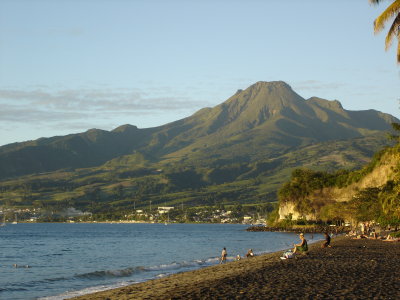
Petit Piton is made up entirely of dacite (a volcanic rock similar to basalt) that is about 260,000 years old--i.e., very recent in geologic terms. It represents the core of a lava dome volcano that formed along the western edge of a large preexisting caldera from a collapsed stratovolcano. The caldera was centered around the present-day sulfur springs a couple of kilometers to the west of Petit Piton. The area is still volcanically active but, apart from minor steam explosions, there have been no eruptions on Saint Lucia in the last few hundred years. Saint Lucia is fortunate to be spared these events, since neighboring Martinique and St. Vincent have been afflicted by the first and ninth most deadly eruptions of the twentieth century, respectively.
Flora

The famous flora of Petit Piton--well, fauna, technically--is the coral found on its submarine slopes; wall dives below the mountain are considered among the best in the Caribbean.
Weather
The weather in Saint Lucia is uniformly hot year-round. You'll do best to start your hiking by 6:00 a.m. Rainfall in the wet season (June-November) is about double the remainder of the year, but showers can occur at any time and, conversely, long stretches of gorgeous weather are possible even in the wettest months. Hurricanes are relatively infrequent in this part of the Caribbean.
Battle of Rabot

Petit Piton was at the center of this struggle in April of 1795, in a battle that shook the confidence of the British Empire and had parallels to Custer's later debacle at the Little Big Horn.
The French Revolution has swept through the Caribbean, with slaves abandoning the French plantations in Saint Lucia en masse and organizing--with support from revolutionaries back in France--into Armée Française dans les Bois (French Army in the Woods). The British called this black army "Brigands" and were determined to stamp it out. They landed a thousand troops in southern Saint Lucia and marching confidently through Laborie and Choiseul in a bid to overwhelm the rebel stronghold of Soufrière. Just two kilometers short of their objective, in a little defile at Rabot under Petit Piton, the "Brigands" stopped the redcoats with a road block, then snapped the trap shut with coordinated forces to the south and on the slopes above. As afternoon turned to evening on April 22 and the shadow of Petit Piton thrust like a lance across the Rabot battlefield, the British force found itself pinned down in a natural shooting gallery, almost out of ammunition. They managed a bedraggled retreat to Choiseul after nightfall--though in the words of the History of the British Army, "the men were so exhausted they could hardly drag their guns." They left a hundred and seventy officers and men dead on the field, and soon abandoned the island entirely. It was the first time the British Army had suffered a significant defeat at the hands of a black foe.
Of course, the Empire always strikes back, and eventually the British juggernaut would overcome the Brigands. In 1797, the Brigand army surrendered, on condition that its members would not return to slavery; instead, they became the West India Regiment in the British Army.
Links
 From La Haut Plantation, dawn
Geology description (Soufriere Foundation)
Superman's Flight (wall dive below Petit Piton)
Nice video comparing the two Piton climbs
Triangle
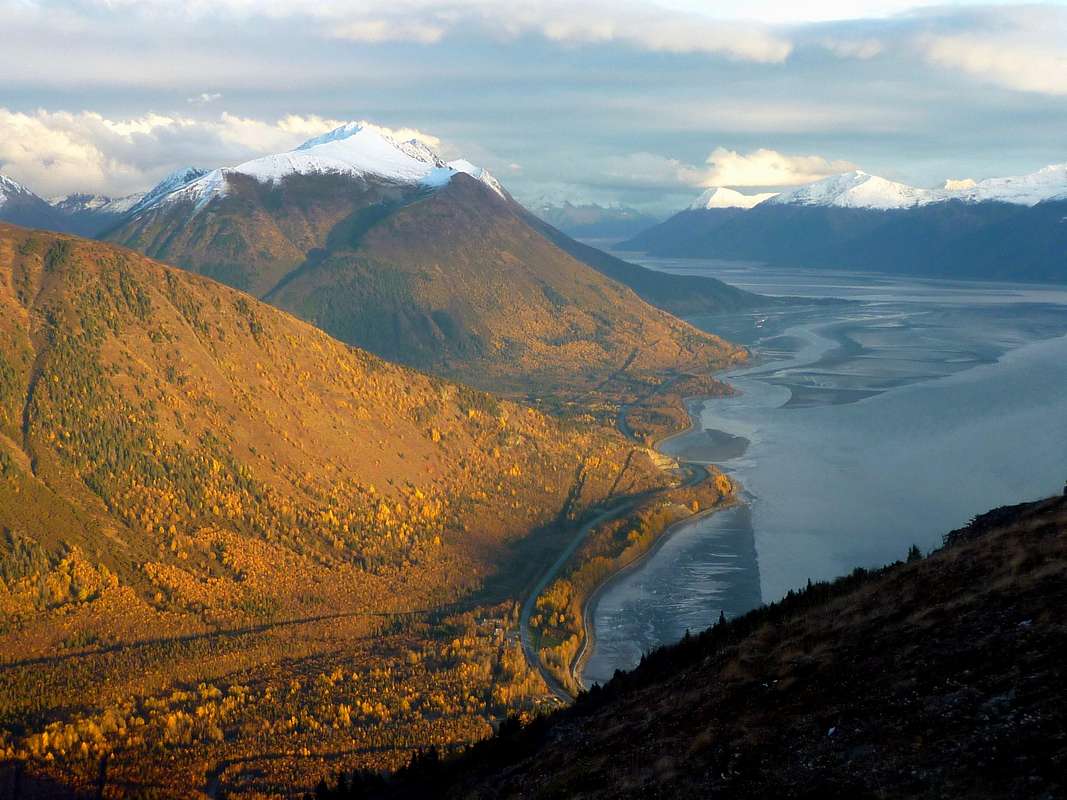
Triangle Peak is the easiest--and one of the prettiest--of the "musical group" of peaks at the head of Chugach State Park's South Fork Eagle River. The peak was named in the 1980s for that least-heard of instruments in the symphony. By either of the routes described on this page, the 17-mile round-trip to Triangle is a magnificent ramble through country that would improve many a national park. Once you arrive, you have a seat in a lofty orchestra, with Concerto and Cantata Peaks, Calliope and Hurdygurdy Mountains looming just above.Getting There
Triangle Peak is approached from the South Fork Valley trailhead in Chugach State Park, reached from central Anchorage in 30-40 minutes' drive. From the northbound Glenn Highway, take the Eagle River Loop Road exit and then turn right at the traffic light onto Hiland Road. Follow this several miles into the South Fork Valley. After crossing a bridge over the South Fork, look for South Creek Road on your right. This is the turnoff for the trailhead, marked with a small brown sign. The trailhead has a gravel parking area which, though spacious, often overflows on summer weekends. There are two good outhouses to get your ready for your trek.
Routes
 Symphony Tarns route in purple, Rendezvous Ridge route in yellow. Click to enlarge. Underlying map by Imus Geographics (out of print).
Now your goal is to get to the inlet stream of Symphony Lake, but you want to wind up on the west side of that inlet. This is most easily accomplished by starting along the cairned route up onto the moraine between Eagle and Symphony Lakes, and then veering right across the boulders to the outlet of Symphony Lake. You'll have to make your own way among the boulders to do this, and it won't be quick, especially if you're doing it in the rain or struggling with a pack. But the outlet is easy to cross dry-shod, and from there a rough trail of use takes you along the west side of the lake to the inlet. Watch for beavers along here. From the inlet, stay on the west side of the stream, scrambling about 100 vertical feet up onto a tundra bench above it. You may see a cairn on this bench, which marks the beginning of an excellent trail that takes you up a draw to the northerly of the two Symphony Tarns, elevation 3400 feet.
From the outlet of the northerly tarn, continue onto the pretty little ridge that splits the two tarns. Ascent this (steep grass) until, at about 4300 feet, it looks feasible to sidehill over to your left onto the big plateau above the more southerly tarn. There's good perennial water here.
Now Triangle Peak is dead ahead and a thousand feet above. The plateau will funnel you onto its southwest ridge, where a trail of use appears again, carrying you to Triangle's west summit. The slightly higher east summit is but a short stroll away.
The whole route never exceeds class 2 in difficulty. A little routefinding savvy is helpful, since several stretches beyond Eagle Lake lack any discernible path. The vertical rise from the trailhead is about 3500 feet, but undulations along the route of march will augment this to well past 4000 feet of climbing. When you factor in the slow going around Symphony Lake, you should probably budget at least five hours one way.
Rendezvous Ridge Route: If the weather is good, there is an even more spectacular way to reach Triangle Peak. Start on the South Fork Eagle River Trail as above, ascending gradually for about a mile and a half. Just before the trail plunges 200 feet to its first crossing of the river, take a smaller trail heading to the right into a big grassy bowl. Climb the bowl onto Rendezvous Ridge, the eight-mile chain of nameless peaks that links Rendezvous Peak with Triangle Peak.
Wandering along this ridge makes a delightful day, with jaw-dropping views over every rise. But there are quite a few rises--by the time you get to Triangle, you'll have climbed more than 5600 feet in total. It's almost all fast walking on good footing, except for a short rugged crest (class 3) above Symphony Lake, which can be bypassed on the right. There's no reliable water along the route until the plateau just west of Triangle itself.
Camping
There are good sites on the moraine between Eagle and Symphony Lakes; at the Symphony Tarns; and on the plateau just west of Triangle Peak. Of these, the tarns might be my first choice for scenic camping with relative solitude.
Red Tape
Chugach State Park has few restrictions on hiking, camping, and climbing. Campfires are not permitted and very large groups will need a permit.
As of 2016 there is no parking fee for the South Fork trailhead.
External Links
Chugach State Park
Listing on Lists of John
Pages 4-6 of this issue of "Scree" tell how the musical group got their names
Triangle in early winter conditions
Photo