
|
|
Route |
|---|---|
|
|
47.77590°N / 121.1195°W |
|
|
Overview

Looking for an excellent backcountry snow-climb, that is not popular, has tremendous views and has a trailhead that is easily accessible in winter. Well the Spinnaker Peak-Martin Peak Traverse located in Stevens Pass, Washington is an excellent pick on a clear and low to moderate avalanche danger day. Despite the summits being in close proximity to Route 2 very few people every climb to these two great summits.
There is a strong reason for that. In summer these mountains are a very intense bushwhack and off trail scramble from the Pacific Crest Trail. Though doable, the terrain and the vegetation on these summits are often very rough to travel once off the Pacific Crest Trail. The few that do summit do it in winter and early spring when most of the rough vegetation and steep slopes are covered with snow. Though the total distance is only 8 miles and maybe 2500 feet at best, 85% of the winter travel is all off trail and most of the time there are no kicked-in steps that will lead to the two summit areas. With perfect conditions it takes any average mountaineer around 8 hours to complete. This though can be dramatically more if the snow conditions are not that good. It should also be noted that there are two major stream crossings so avoid choosing this trip after a Pineapple Express rainstorm or after a period of warmer than average weather.

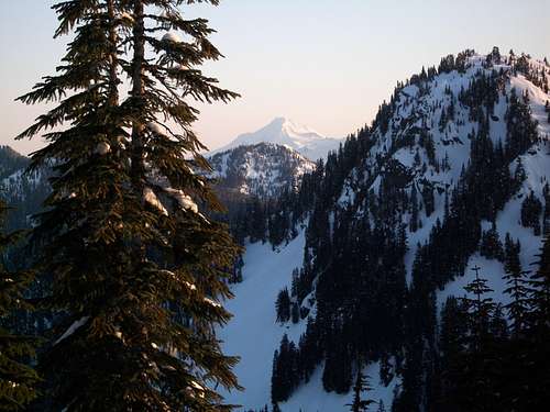
On a clear day, these summits have remarkable views. One can see hundreds of summits from each of these peaks including Mount Rainier, Glacier Peak, Mount Baker, Mount Stuart and Mount Daniel. Out of the two summits Martin Peak the slightly smaller summit has the better views with the true summit being completely unobstructed. An amazing 360 degree panorama can be obtained from this summit. The slightly higher Spinnaker Peak does have some tree cover on top. However there are open areas within the trees that offer tremendous views of the Cascades, just not quiet has open as the true summit of Martin Peak.

If one in search for a little more of a challenge and more views they can also add Point 5261 which marks the northeast beginning of the ridge. It is recommend though that the climber bring an ice axe due to the fact that this sub-peak contains a narrow steep ridge that can easily ice over if windblown. Views on Point 5261 as well as the traverse along the ridge are very beautiful and if the conditions are right, the little bit more of effort and exposure is well worth it.
Getting There
VIA STEVENS PASS: Take Route 2 to two miles east Stevens Pass. Stevens Pass is located 20 miles east of Skyomish and 30 miles west of Leavenworth. You want to park in Stevens Pass Ski Area overflow lot on your south side 2 miles east of the main ski area. There will be a building that is marked no tresspassing and no parking to the right of the building. That is residence for the workers of the ski area. The large parking to the left is the overflow and is legal to park there. From there just go accross that street and go down the street for the winter route.Route Description

From the Yodelin Parking Lot you want to take the road across the street. It will quickly become snow-covered and only snowmobile will be able to travel that road during the winter. You want to merge right at a T intersection and take the road and walk all of the way to the very end which will be roughly a 1/2 a mile. From there you will want to bushwhack into the woods.

It is highly recommend that you head downhill slightly to the right so that this way you can be close to Nason Creek. Often the snow bridges are steadier downstream because the water is moving slower causing it to freeze earlier. You first cross the creek that goes into the Hyak-Sky Mountain Basin. A little while later you will then cross the Nason Creek. At the time of this climb there was a decent snow bridge that had formed from a log that fell across the creek. This is probably temporary so do not expect it to be there next year.
From there you will enter in what in summer would be a meadow on the south facing side of Lichtenburg Mountain. From there you will reenter the woods and continue to run parallel to Nason Creek as it slowly rises. Eventually you will hit a nice open basin where Tye Peak, now to your south will be towering over you and the ridge that contains Spinnaker and Martin will be northwest of you. For just the summits of Spinnaker and Martin you want to go up divide between the east and west drainage basins and then start heading up the ridge in a due western fashion. You want to slightly angle to your left as you are rising up the mountain. From here you will rise roughly 700 feet at about a 35 degree angle. Luckily going up this ridge is mostly forested though some views of Tye Peak come out between the trees. Head all the way up until you reach the col between one of Spinnaker sub peaks and the ridge leading to the true summit.
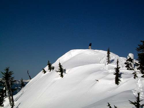
Once on the ridge make a left and head southwest toward the summit of Spinnaker. Though the ridge contains many moderate sized and stunned trees, great views often peak out of the hundreds of neighboring alpine mountains. Continue to rise along the ridge until you reach the true summit of Spinnaker Peak.
The views on Spinnaker Peak are great but for mind blowing views you will want to continue to neighboring Martin Peak. To head to Martin Peak from Spinnaker Peak you want to continue to head southwest where you will quickly drop 150 feet into a col. From there you rise again 130 feet to neighboring Martin Peak. It will be lightly forested with many open views at first but then the most southern rock of Martin Peak will becoming completely open for a true alpine feeling and a 360 degree panorama.

If you which to add Point 5261 to your destination list then instead of heading down between Spinnaker and the sub summit you want to continue along the ridge traverse over and around sub summits. There will be one stretch heading to Point 5261 where you will be heading up a narrow steep ridge up to the summit. An ice axe is recommended here especially if the snow is compact and icy. Point 5261 is another spot on the ridge which has a bit of alpine character and 360 degree views including a close-up of Spinnaker. From there head down the steep terrain back to basin that feeds Nason Creek. If the conditions are good this side trip is well worthwhile but if conditions are back this section should be avoided.
Essential Gear
This is a winter snowclimbing trip. Therefore in addition to the 10 essentials, you must also bring snowshoes and trekking poles. An ice axe is highly recommended for the standard route and required if you plan on get Point 5261 as well.External Links
For the best weather and snow conditions in the immediate surrounding reach go www.stevenspass.com or click hereWeather Links
Here is a link to shots of live shots of Stevens Pass.Here is the NOAA forecast for the western Cascades