
-
 7277 Hits
-
 78.27% Score
-
 9 Votes
|
|
Route |
|---|---|
|
|
52.09385°N / 116.69815°W |
|
|
Mountaineering |
|
|
Summer |
|
|
One to two days |
|
|
5.4 (YDS) |
|
|
II |
|
|
Overview/Approach
Mount Cline is one of the coveted 54 11,000’+ summits in the Canadian Rockies. Its main claim to fame amongst this group is that it is one of if not the driest of its brethren being located well east of the Continental Divide between the Saskatchewan and Cline rivers just outside of Banff National Park. Historical Canadian Rockies mountaineer Rudolph Aemmer and outfitter Jimmy Simpson made the first ascent of the Southwest Ridge (II, 5.4), the most common route on the mountain today, in 1927.


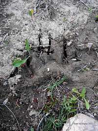
For me and others, this route’s main attraction could be its bivy site below the final approach headwall which eventually leads to the ridge itself. Although I could have climbed this route in a push from car to car with a light pack, which would be my typical choice, I anticipated the opportunity to enjoy a night at the north end of several beautiful small tarns hemmed in by slab thrusts on both sides. Although Bill Corbett’s guide book references a 4-5 hour approach to this bivy site, I made it in 2:45. However, I did choose to solo the southwest ridge without any technical gear whatsoever, no alpine ax, no crampons, no rope nor harness. Just boots, poles, a bivy sack and some food. So the approach was light and fast. I saw one grizzly track the size of my hand just below the bivy site, so this is active bear habitat (2011). Total elevation gain from the parking area to the summit is over 6000’.
Bill Corbett’s approach directions were less than stellar. He starts out by referencing a trail on the left side of Thompson Creek from the north west side of Highway 11 (David Thompson Highway). In reality, it starts on the right side of Thompson Creek. At about 20 minutes cross two log bridges back to back which will land you on the left side of the left fork at the split in the creek. In 2011 I found the first bridge in good condition, the second in bad condition. If this second bridge is washed out at the lower falls of this left branch, there will be safer crossings up stream. Once on the left side of the left fork, follow it for quite a few kilometers up stream following a trail sometimes through downed trees, other times on the rocky creek bank.
Before you reach a much larger fall in the left fork, look for a well cairned (2011) trail leading up left on moraine. Follow the left side of this moraine gully until about half way up to the steep wall above. Look for a flagged trail (2011) that crosses the moraine gully to the treed side (right) and continue up through trees angling right to reach a long open traverse on larger scree slopes. Corbett’s notes are quite unclear about when to leave the moraine gully, but it is actually below what looks like an obvious treed ramp which is what he mentions. That treed ramp will go, it is just not as well traveled. The trail will traverse several large scree slopes well up hill from the drainage exiting a twin waterfall ahead. Aim for the upper left corner of the twin waterfall headwall. That is where I encountered grizzly bear prints about the size of my hand (photo) and a lot of dug up ground consistent with bear habitat. Continue up the drainage that feeds those waterfalls until you reach another much shorter headwall. Scramble up it on its right side. Then continue up stream until you reach the pristine tarns/lakes Corbett mentions as one of the more scenic bivys of any of the 11,000’+ group. Bivy at the north end of the main lake where there is a small inlet of good underground flow water.
Route Description (s)
This is a 6000’+ accumulated elevation trip.Take the obvious ramp, right to left, up the headwall above the bivy site. Corbett’s notes are again void of good detail here and could cost you time if you took them literally, i.e. you still cannot see Mount Cline from this juncture as he alludes to. Also do not turn immediately right and head north as his notes indicate as well. Instead follow the drainage all the way up to the obvious col between a jagged ridge peak on your left and the relatively flat south ridge of Mount Owen to the north. This col is approximately at 9000’ and from the col proper, Mount Cline is now in full view beyond Mount Owen.
I chose to run up a decent scree trail to the summit of Mount Owen (10,000+/-), which contained a summit log in 2011, then descended back to the col. This extra peak bag adds approximately 1000’ elevation to your day.
From the col, cross a large snow slope heading northeast which sits atop a small glacier below the west flank of Mount Owen. Some folks would be more comfortable with crampons and alpine axes through this area depending on conditions. There would be consequences with an un-arrested fall here. I crossed the hard snow with boots and poles and felt comfortable doing so. Once on the other side of this large snow slope, look to intersect Mount Cline’s southwest ridge on the left side of a perfectly U shaped notch by scrambling up loose and stiff scree. Once on the ridge, follow it to the summit.
Along the way, you will come across the crux of the climb, two back to back narrow notches that must both be down climbed and ascended up the other side, rated at 5.4 and even higher on some guides websites. I felt 5.4 was more than adequate. The rock was solid going and coming in my opinion. Many make a big deal about the exposure of these notches but I felt it was no more than I have seen on the more difficult scrambles in the Canadian Rockies. There was a fixed rap station at the first notch and only a single piton at the far side of the second notch in 2011 although decent features exist to sling for whatever system you desire to set up. It took me a few minutes to solo both notches both directions and both were completely dry in August, 2011.
From there, continue up the easy scree slopes to the summit. A summit register existed in 2011 but was in bad shape (wet) and needs to be replaced. Return the entire route and approach. It took me over 3 hours to summit both Mount Owen and Mount Cline, less than 2 hours to descend back to camp and less than 2.5 hours to hike back out to the car.
Climbing Sequence
 |
 |
 |
 |
 |
 |
 |
Essential Gear
I did a solo trip of this ridge which included boots, poles, a bivy sack and some food. An ACC led trip which was at the bivy the night I arrived had large packs, helmets, crampons, alpine axes, multiple ropes, large expedition style tents, large stoves (boiling drinking water), etc, etc. So somewhere in between gear wise might make some sense depending on your comfort level with that sort of terrain and willingness to carry weight.External Links
100’s of Canadian Rockies multi-pitch rock climbs, ice climbs, alpine climbs and scrambles, just scroll down to routesBanff National Park, Parks Canada
Best Eats in Canmore: Iron Goat, tons of organic/free range fare, my favorite is the game meat loaf. As good as prices as anywhere really and the staff is made up of a few aspiring climbers. The main man works his heart out making everything run smooth, not a given in Canmore. Best dining views (and sunny outdoor seating) in town bar none, from Mount Lougheed to Mount Rundle traverses, two of my trademark beta contributions near the town of Canmore. True best of the best mountain local dining experience.
Best Eats in Banff: The Bison, all organic/free range fare, with a detailed description of their suppliers. Recently expanded (2010), I recommend sticking with the downstairs. Better menu, prices and social ambience. Maybe retire to the bar upstairs for sunset or late night. Bison chili is amazing!
Best Coffee in Canmore: Beamers, the locals favorite, super wholesome lunch stuff, local guys, no attitude on service
Best Climbers Hangout: Summit Café, most likely place to find me or my brethren shooting the bull about beta. Best breakfast place in town, good coffee as well, serve Mennonite meats from Valbella, which is the best place to buy free range products anywhere in the world, right here in Canmore.
Climbing Gear: All way too expensive in the Bow Valley, but if you must, Mountain Magic in Banff is far superior to service and actual knowledge about climbing than the two in Canmore.