
-
 2954 Hits
-
 73.06% Score
-
 3 Votes
|
|
Route |
|---|---|
|
|
46.47469°N / 13.39791°E |
|
|
Download GPX » View Route on Map |
|
|
Hiking, Scrambling |
|
|
Spring, Summer, Fall |
|
|
Most of a day |
|
|
a quite difficult hike/scramble up |
|
|
Overview
This is not the shortest and easiest ascent route on this mountain, but suitable if you find yourself on Bieliga pasture anyway, or if you want to do a nice round tour. The crossing of the rugged southern slopes of Monte Sechieiz o Berda is hard on one or two places, because the once comfortable mule track is completely ruined there. And, as said, the reward is one of the best views in Julian Alps - on the mighty Montaž from the NW. This route can be nicely combined with the other ascent from Dogna valley - you can descend down to Mincigos hamlet and by the road further to Chiout. That's a nice 7-8 hours hike/scramble up.
Rating the Route (By Hiking Standards)
The grading system for hiking and scrambling routes is here.
0. General: From 838 m to 1943 m, exposition S and W. At first a comfortable mountain road, then a mule track, which is partially ruined and requires easy climbing (also protected by a cable), finally steep scramble up the grassy, scree and rocky slopes. Gear: Good hiking shoes and poles. By the Swiss Scale for grading hikes the difficulty would be T4 (only the ruined passages and the final 100 meters of ascent).
1. Effort: cca 1100 m, 4 h.
2. Power: 3 - Moderate. The ruined part of the mule trail.
3. Psyche: 3 - Moderate. The passages on the crossing, the upper slopes are also steep, but not very exposed.
4. Orientation: 3 - Moderate - only the upper 100 meters.
Getting There
See the main page of Cuel dei Pez, how to get into the valley of Dogna! The parking place is in the village of Chiout.
Route Description
From Chiout you take the narrow road towards Bieliga alpine meadow (Casera Bieliga). It is marked No. 601. The road is probably closed for public traffic (no sign below), anyway it's narrow and steep in some places, bul locals do drive up. In 2011 we saw they are building the last part, just on the pasture. For walking the road is comfortable and relaxing, also the pine woods are nice. On some 1330 m you pass a forrest hut, then you continue by the road towards the meadow (path No. 601 deters left up). When reaching the creek bed of Rio Bieliga, you are already below the pasture. There the path No. 649 deters right (towards the east) - on the opposite slope and you take it.
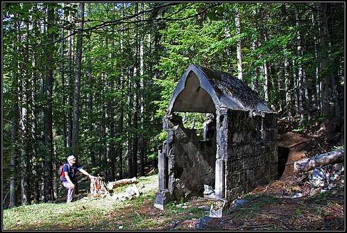 The chapel. Photo: Jasmina Pogačnik. |
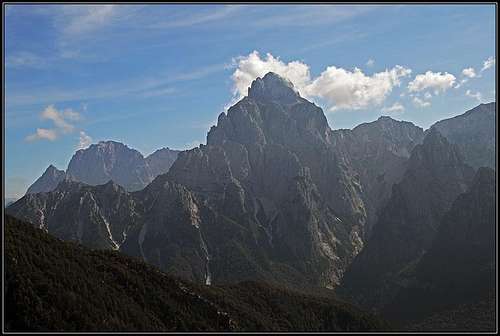 The view on Montaž |
After one turn the broad mule trail passes ruins of a picturesque chapel from the World War I. You follow the marks right and up and in a few turns gain some altitude. Then the nice mule trail continues across the slopes of Monte Sechieiz o Berda and soon you come out of the woods. Great views towards Montaž open there! The horizontal path soon reaches two old wooden bridges, which look weak, but with a steel cable they are still safe to cross them. We continue by a nice ledge into the upper ravine of Rio Mincigos. There the military bridge is completely gone, so you must overcome a 5 meters high, vertical rock drop. Also the continuation on the other side of the ravine looks scary, but don't stop there. Climb down, then ascend steeply by the ravine some 10 meters, cross the soft and steep screes until you hold firmly the loose cable. Pull up and you are on a comfortable ledge. A bit further there is one more place where some care is needed - the place is secured well and equipped with a short ladder. After this last obstacle the path is wide and comfortable again. In the distance you see already Forcella Cuel Tarond / Vančela and you need only to hike that distance.
 Wooden bridges |
 The upper Mincigos ravine |
 Military path |
To climb Cuel dei Pez one must continue towards the SE (while the path No. 647 crosses the saddle). The path first passes horizontally the slope, then starts to ascend in curves. The SW slopes of our mountain are covered with pine bushes. The path (Sentiero Battaglione Gemona) is clearly oriented towards a distinct notch in the side, SW ridge. Right of the notch is a big rock tower. The notch is the highest point of the path in this area. If we want to climb the summit of Cuel dei Pez, we must deter from it towards the north and scramble over a pathless terrain.
The first option to go up is the last scree field (steep and soft) before the notch - so still over the SW slope. Perhaps you can leave the path also earlier and go up towards the NW ridge. By either side of the scree field we ascend steeply up. A few passages require some care and choosing the best option. Above, the terrain is still steep, but more grassy and rocky. Just below the summit ridge you will even hit a path, probably originating from the WW1. On top there are ruins of buildings again.
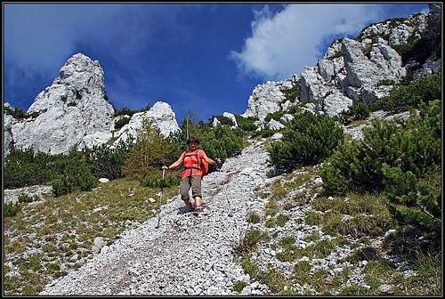 Scree field
The second option is perhaps to go on top directly from the notch. There are traces through pine bushes, but we haven't tried that passage. From the distance it looked possible (without harder climbing).
The third option is to continue from the notch by the marked path towards the east, and to ascend on top only when you already pass the summit for some 200 meters. By a steep, grassy slope (weak trails) you ascend up towards the SE ridge (carefully). When reaching it, you notice remains of a trench. By it and by the slopes left you go up, reaching the steep summit rock barrier. There you best go left, using a narrow ledge, which brings you in a steep ravine just below the summit. There you go directly up on top.
You best descend by one of these options. We went up by the SE route and descended by the SW screes.