
-
 2756 Hits
-
 75.81% Score
-
 6 Votes
|
|
Route |
|---|---|
|
|
37.26776°N / 112.93355°W |
|
|
Hiking |
|
|
Spring, Summer, Fall, Winter |
|
|
Most of a day |
|
|
Overview
Although this is neither the shortest nor the easiest way to Cable Mountain, it is the most scenic (and probably the most strenuous, though not the most technically difficult).
Starting from Weeping Rock, a popular shuttle stop in Zion Canyon, the route climbs steeply to Echo Canyon, where the grade abates as one passes beside and above (but not through) some slots, and then ascends to the plateaus of the Zion high country.
Views of Zion Canyon are outstanding for much of the way, and then there are the aforementioned slots.
If you can arrange a vehicle shuttle, I would highly recommend using the East Entrance or Many Pools route to approach and this route to descend.
Getting There
Except during winter, you must use the free shuttle in Zion Canyon to get to Weeping Rock. Information on the Zion shuttle system
Route Description
The start is the hardest part. For about a mile, the trail climbs steeply via switchbacks to reach a junction with the trail to Hidden Canyon (0.7 mi from TH; go left at the junction) and then into Echo Canyon, gaining about 1000'. The water in Echo Canyon is cold even in summer, but it is usually possible to cross the stream and hike beside it without getting your feet wet.
 |
 |
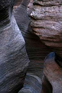 |
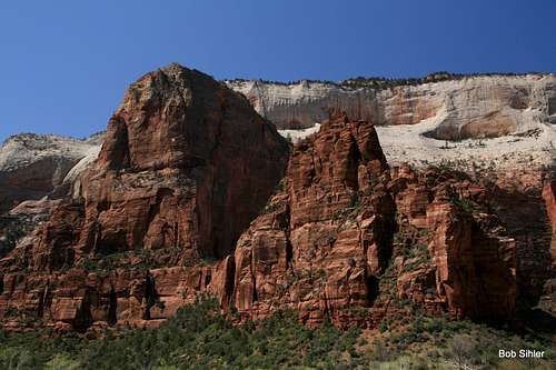
As you go up the switchbacks, take time to stop and admire the scenery, which gets better the higher you go. And as you reach Echo Canyon, you hike beside and beneath the sheer walls of Cable Mountain, a spectacular sight.
 |
 |
2.1 mi from the TH, there is an intersection with the East Rim Trail. Going left will take you to Observation Point. To go to Cable Mountain, though, bear right. Now you are ascending into Zion's high plateau country, with nice views of Cable Mountain as you do so.
 |
 |
In 2.3 mi, bear right at another junction and bear right again in 0.4 miles for Deertrap Mountain and Cable Mountain. Then bear right yet again after 1.1 mi. Now you are on the dead-end trail for Cable Mountain.
The summit of Cable Mountain is only about a quarter-mile away at this point, but the views are very limited there. To get to the overlook of Zion Canyon, you have to hike another 1.8 mi from the last junction, losing about 500' from the summit to the overlook.
So in all, you're looking at 15.4 mi round-trip, with a total elevation gain of around 3100'.
When To Go and What To Bring
Although the trail is accessible all year, spring and fall are best. Summer days can be unpleasantly and dangerously hot, and late fall through early spring, there likely will be dangerous snowbanks on the switchbacks up to Echo Canyon. Even though this "climb" is just a Class 1 hike, snowy conditions might necessitate the use of an ice axe or at least trekking poles.