
-
 5430 Hits
-
 78.27% Score
-
 9 Votes
|
|
Fact Sheet |
|---|---|
|
|
Aosta |
OVERVIEW more and more to the East
 |
TOPOGRAPHIC PREAMBLE
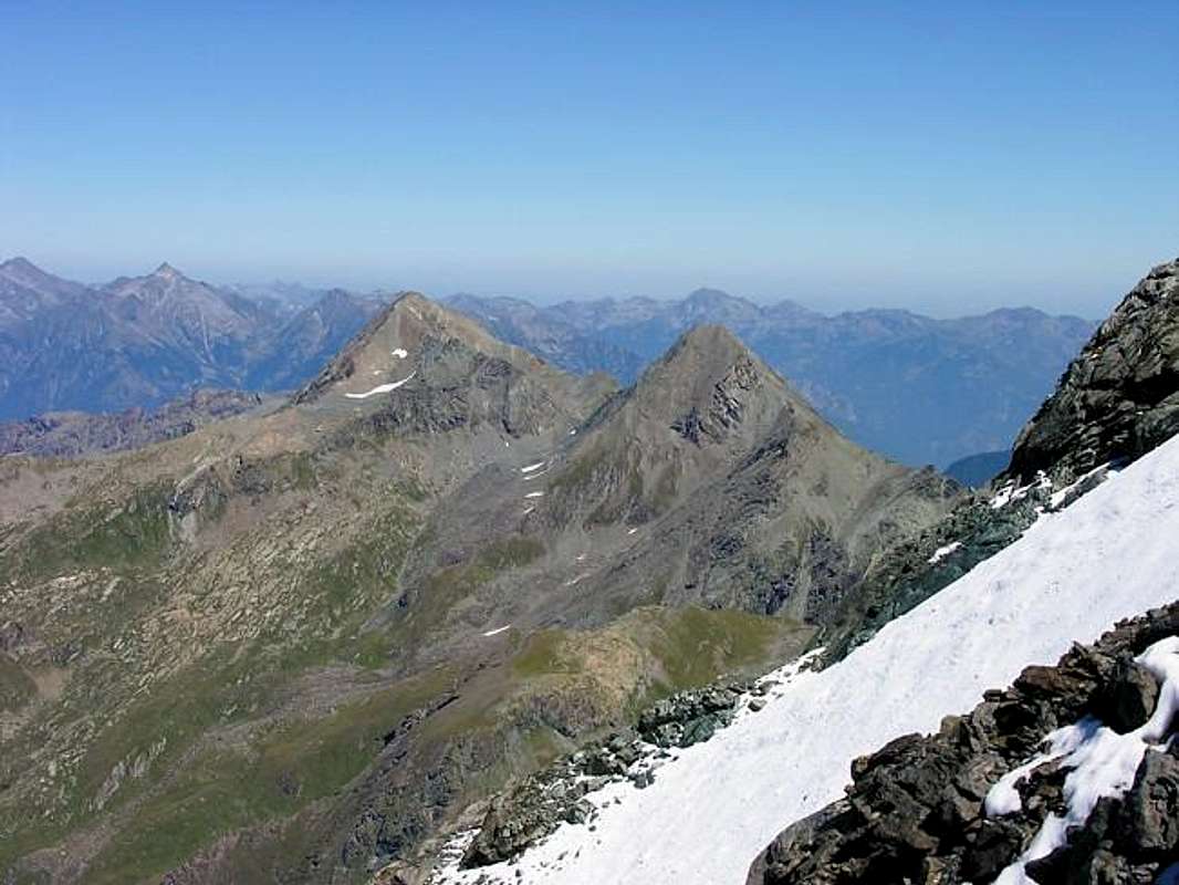
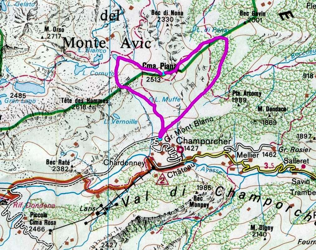
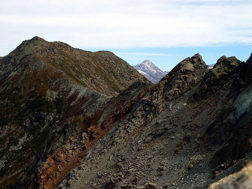
From Punta Tersiva, even more precisely, from the Pontonnet Tower (3174m) and the homonymous Hill (2897m), located just to the South at the end of the Southeast Ridge, the result is a new group of mountains that extend eastward forming the Graian Eastern. Paradoxically, these are the most uprisings in the West observing everything from a general context in deployment of the Alps, but, taking as key points of the Gran Paradiso in the center and Mount Blanc in the Northwest, this is the right place and its name. The watershed ridge rises to the Tower Moussaillon or Moutsaillon and, after the homonymous hill, reaches the Mount Delà (3139m) and from this, turning to the North-northeast, falls Fussì Pass (2912m) to reach the Mount Glacier (3186m), the highest peak of this sector, through its challenging enough Southwest Ridge. From this happen three major branches: the first to the North-northwest down to the Eyèle Pass or Etsely , gets up to Mont Raf( f )rey or Refrey (3146m), near Bec de Viot to conclude the Bec of Ansey, above the splitting of the Valley Fénis-Clavalité/Savoney Walloon, this last to the East, and the second to the North, which forms the e and Point Mezove or Medzove, Mount Iverta, Raye Chevrère large Hill, Mount Avic (3006m), the Hill Varotta and Mount Rouvì or Revic (2922m). From this last point three ramifications from the left (West) on the right are respectively the Arete de Ponton, the short dorsal Hill and Mont Giron and Cima Nera and the most important dividing crest of the Walloon Valmeriana (West) from the Valley of Champdepraz also called Valley of the Lochs. In its development form the Fourchettes of Rouvic ,the Hill of Valmeriana, Mount Barbeston (2482m) to finish with Mount Lyan, above Montjovet little Town.
The second major branch goes instead to the East and from Glacier form the two hills of the same name of Great Rossa, Bocon Damon, the Tete des Hommes, the Turret and reaches two important parallel hills of the White Lake and of the Cross, these to connect the two Valleys Champdepraz (Barbustel Refuge just below and to the North of the same) and Champorcher. Over the ridge rises to Cima Piana (2512m), from which again divides into two branches: one Northern to Mount Grimon, Mont La Pertze and Bec of Nona, inside the Natural Park of Mount Avic and the other instead, more extensive, stretching to the East-southeast forming Cima Perche, Terra Rossa and Brenve Passes, Hill and Point of Arcomy (1991m), Bec of Nona, Possoney and Plan Fenetre Passes, Tete of Mont, Tete Colon, Brequet Hill, Mount Charvatton (1787m; beautiful and important routes in rock sound, quite popular) to finish at Col Courtil, between the little Towns of Pont Bozet and Hone (Napoleonic Fortress beautiful, recently restored).
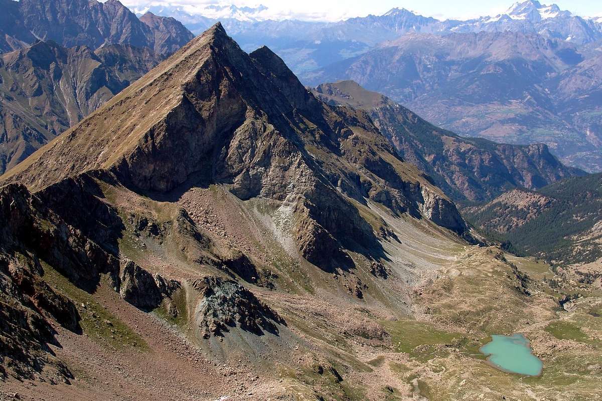
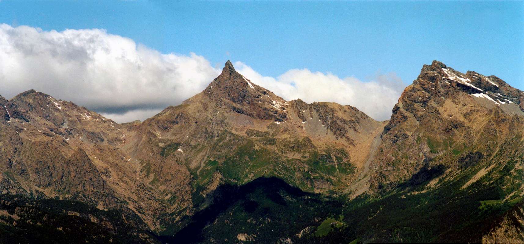
From Money Loch to Garin Peak, with South-eastern View, by emilius
INTRODUCTION
Performed this duty preamble, in order to understand the placement and the right relationship, between the mountain ranges, there should be emphasized that this Second Part of Curtain XI° must be in turn into two distinct areas:
1)- the first that analyzes all the mountains more opening to the East, ie from the Tower Pontonnet to Mount Glacier and the branches above. This sector contains all the chains in the North of Torrent Ayasse, which, in turn, divided into two parts the Champorcher Valley and all of these walloons descend perpendicularly to the River Dora Baltea and then towards the central axis of the Aosta Valley in the area Media and the Low.
2)-: The second, momentarily "hosted" at least in the titles, this relates to the mountains south of the Rosa dei Banchi and, therefore, situated more towards Southeast, and these form walloons that descend perpendicularly to the Torrent Ayasse, then the Municipalities of Champorcher and Pont-Bozet. Most other walloons to the East down, wild, rushing towards the central axis in the direction of the Municipalities of Bard, Donnas and Pont Saint Martin, in what is known as on-site Lower Valley. Also of this vast area, which we will discuss in Part Three of Curtain XI, note the highest mountain as well known, namely the Rosa dei Banchi (3164m). Along with Mont Glacier form the Emblem of the Champorcher Valley.
Even in these two areas, East and Southeast, we will talk, of course as this is not the goal of a more just mountaineering guide, not all the mountains, but that some of them, or to historical peculiarities and characteristics, place names and topographical or simply because they are linked to memories of personal ascensions, more stimulated Fantasy.
"Gradually we move more towards the East / Progressivamente spostiamoci di più in Est", by emilius
PREAMBOLO TOPOGRAFICO
From Punta Tersiva, even more precisely, from the Pontonnet Tower (3174m) and the homonymous Hill (2897m), located just to the South at the end of the Southeast Ridge, the result is a new group of mountains that extend eastward forming the Graian Eastern. Paradoxically, these are the most uprisings in the West observing everything from a general context in deployment of the Alps, but, taking as key points of the Gran Paradiso in the center and Mount Blanc in the Northwest, this is the right place and its name. The watershed ridge rises to the Tower Moussaillon or Moutsaillon and, after the homonymous hill, reaches the Mount Delà (3139m) and from this, turning to the North-northeast, falls Fussì Pass (2912m) to reach the Mount Glacier (3186m), the highest peak of this sector, through its challenging enough Southwest Ridge. From this happen three major branches: the first to the North-northwest down to the Eyèle Pass or Etsely , gets up to Mont Raf( f )rey or Refrey (3146m), near Bec de Viot to conclude the Bec of Ansey, above the splitting of the Valley Fénis-Clavalité/Savoney Walloon, this last to the East, and the second to the North, which forms the e and Point Mezove or Medzove, Mount Iverta, Raye Chevrère large Hill, Mount Avic (3006m), the Hill Varotta and Mount Rouvì or Revic (2922m). From this last point three ramifications from the left (West) on the right are respectively the Arete de Ponton, the short dorsal Hill and Mont Giron and Cima Nera and the most important dividing crest of the Walloon Valmeriana (West) from the Valley of Champdepraz also called Valley of the Lochs. In its development form the Fourchettes of Rouvic ,the Hill of Valmeriana, Mount Barbeston (2482m) to finish with Mount Lyan, above Montjovet little Town.
The second major branch goes instead to the East and from Glacier form the two hills of the same name of Great Rossa, Bocon Damon, the Tete des Hommes, the Turret and reaches two important parallel hills of the White Lake and of the Cross, these to connect the two Valleys Champdepraz (Barbustel Refuge just below and to the North of the same) and Champorcher. Over the ridge rises to Cima Piana (2512m), from which again divides into two branches: one Northern to Mount Grimon, Mont La Pertze and Bec of Nona, inside the Natural Park of Mount Avic and the other instead, more extensive, stretching to the East-southeast forming Cima Perche, Terra Rossa and Brenve Passes, Hill and Point of Arcomy (1991m), Bec of Nona, Possoney and Plan Fenetre Passes, Tete of Mont, Tete Colon, Brequet Hill, Mount Charvatton (1787m; beautiful and important routes in rock sound, quite popular) to finish at Col Courtil, between the little Towns of Pont Bozet and Hone (Napoleonic Fortress beautiful, recently restored).
 |
INTRODUCTION
Performed this duty preamble, in order to understand the placement and the right relationship, between the mountain ranges, there should be emphasized that this Second Part of Curtain XI° must be in turn into two distinct areas:
1)- the first that analyzes all the mountains more opening to the East, ie from the Tower Pontonnet to Mount Glacier and the branches above. This sector contains all the chains in the North of Torrent Ayasse, which, in turn, divided into two parts the Champorcher Valley and all of these walloons descend perpendicularly to the River Dora Baltea and then towards the central axis of the Aosta Valley in the area Media and the Low.
2)-: The second, momentarily "hosted" at least in the titles, this relates to the mountains south of the Rosa dei Banchi and, therefore, situated more towards Southeast, and these form walloons that descend perpendicularly to the Torrent Ayasse, then the Municipalities of Champorcher and Pont-Bozet. Most other walloons to the East down, wild, rushing towards the central axis in the direction of the Municipalities of Bard, Donnas and Pont Saint Martin, in what is known as on-site Lower Valley. Also of this vast area, which we will discuss in Part Three of Curtain XI, note the highest mountain as well known, namely the Rosa dei Banchi (3164m). Along with Mont Glacier form the Emblem of the Champorcher Valley.
Even in these two areas, East and Southeast, we will talk, of course as this is not the goal of a more just mountaineering guide, not all the mountains, but that some of them, or to historical peculiarities and characteristics, place names and topographical or simply because they are linked to memories of personal ascensions, more stimulated Fantasy.
 |
PREAMBOLO TOPOGRAFICO
Dalla Punta Tersiva, anzi, più precisamente, dalla Tour Pontonnet (3174 m) e dall'omonimo Colle (2897 m), posto appena più a Sud al termine della Cresta Sudest, si profila un nuovo gruppo di montagne, estendentesi verso Oriente costituendo le Alpi Graie Orientali. Paradossalmente, queste sono quelle maggiormente rivolte ad Occidente osservando il tutto da un contesto generale nel dispiego dell'arco alpino; ma, prendendo come punti cardine il Gran Paradiso al centro ed il Monte Bianco al Nordovest, questa risulta la giusta collocazione e relativa denominazione. La cresta spartiacque sale alla Tour Moussaillon o Moutsaillon e, dopo l'omonimo colle, raggiunge il Mont Delà (3139 m); da questo, piegando a Nord-nordest, scende al Col Fussì (2912 m) per raggiungere il Mont Glacier (3186 m), vetta più elevata di tutto questo settore, tramite la sua abbastanza impegnativa Cresta Sudovest. Da questo avvengono tre importanti ramificazioni: la prima verso Nord-nordovest scende al Col d'Eyèle o Etsely, si alza al Mont Raf(f)rey o Refrey (3146 m), al viciniore Bec de Viot per concludere al Bec d'Ansey, al di sopra dello sdoppiamento della Valle di Fénis-Clavalité con il Vallone di Savoney, ad Oriente; la seconda a Nord formante il Colle e la Punta di Mezove o Medzove, il Monte Iverta, il Colle Raye Chevrère, il Monte Avic (3006 m), il Colle Varotta ed il Mont Rouvì o Revic (2922 m). Da questo ultimo dipartono tre ramificazioni che da sinistra (Ovest) a destra costituiscono rispettivamente l'Arete de Ponton, la breve dorsale Colle e Mont Giron e Cima Nera e la più importante cresta divisoria il Vallone di Valmeriana (Ovest) dalla Valle di Champdepraz o Valle dei Laghi. Nel suo sviluppo forma le Fourchettes del Rouvic, il Colle di Valmeriana, il Monte Barbeston (2482 m), per terminare con il Monte Lyan sopra Montjovet.
La seconda grande ramificazione si spinge invece verso Oriente e dal Glacier forma i due colli con lo stesso nome della Gran Rossa, il Bocon Damon, la Tete des Hommes, la Torretta e raggiunge i due importanti colli paralleli del Lago Bianco e della Croce, tali da collegare le due Valli di Champdepraz (Rifugio Barbustel appena sotto e a Nord dei medesimi) e di Champorcher. Oltre la cresta si eleva alla Cima Piana (2512 m) dalla quale nuovamente si divide in due rami: uno a Nord verso Mont Grimon, Mont La Pertze e Bec di Nona, all'interno del Parco Naturale del Monte Avic; l'altro invece, più esteso, si allunga a Est-sudest formando Cima Perche, Colle di Terra Rossa, Colle di Brenve, Colle e Punta di Arcomy (1991 m), Bec di Nona, Colle di Possoney, Col de Plan Fenetre, Tete du Mont, Tete Colon, Col Brequet, Mont Charvatton (1787 m; belle ed importanti vie su roccia sana, abbastanza frequentate) per terminare al Col Courtil, tra gli abitati di Pont Bozet e Hone (splendida Fortezza Napoleonica, da poco tempo restaurata).
From Tersiva the watershed go to East, with East-southeastern View, by emilius
PREMESSA
Effettuata questo doveroso preambolo, onde fare comprendere il collocamento nonché il giusto rapporto, tra le catene montuose, v'é da evidenziare come questa Seconda Parte di Curtain XI° dev'esser a sua volta in due ben distinte aree:
1)-: la prima analizzante tutte le montagne più rivolte ad Est, cioé dalla Torre Pontonnet al Glacier ed alle ramificazioni di cui sopra. Questo settore contiene tutte la catene a Settentrione del Torrent Ayasse, che, a sua volta, risulta divisorio in due parti della Valle di Champorcher; tutti questi valloni "cadono" perpendicolarmente verso il Fiume Dora Baltea e quindi verso l'asse centrale della Valle di Aosta nella zona Media ed in quella Bassa.
2)-: la seconda, momentaneamente "ospitata", almeno nei titoli, in questa, riguarda le montagne a Sud della Rosa dei Banchi e, quindi, situate più verso Sudest; queste formano valloni discendenti in perpendicolare verso il Torrent Ayasse, quindi verso i Comuni di Champorcher e Pont-Bozet. Più ad Est altri valloni calano, selvaggi, precipitando verso l'asse centrale in direzione dei Comuni di Bard, Donnas e Pont Saint Martin, in quella che vien definita in loco Bassa Valle. Di questa altresì vasta area, della quale tratteremo nella Terza Parte di Curtain XI°, s'evidenzia la montagna più elevata nonché conosciuta, ossia la Rosa dei Banchi (3164 m). Insieme al Mont Glacier formano l'Emblema della Valle di Champorcher.
Anche di questi due settori, Est e Sudest, parleremo, logicamente non essendo questi l'obiettivo più proprio d'una guida alpinistica, non di tutti i monti ma d'alcuni d'essi che, o per peculiarità e caratteristiche storiche, toponomastiche e topografiche o semplicemente perché legate a ricordi di personali ascensioni, maggiormente hanno stimolato la Fantasia.
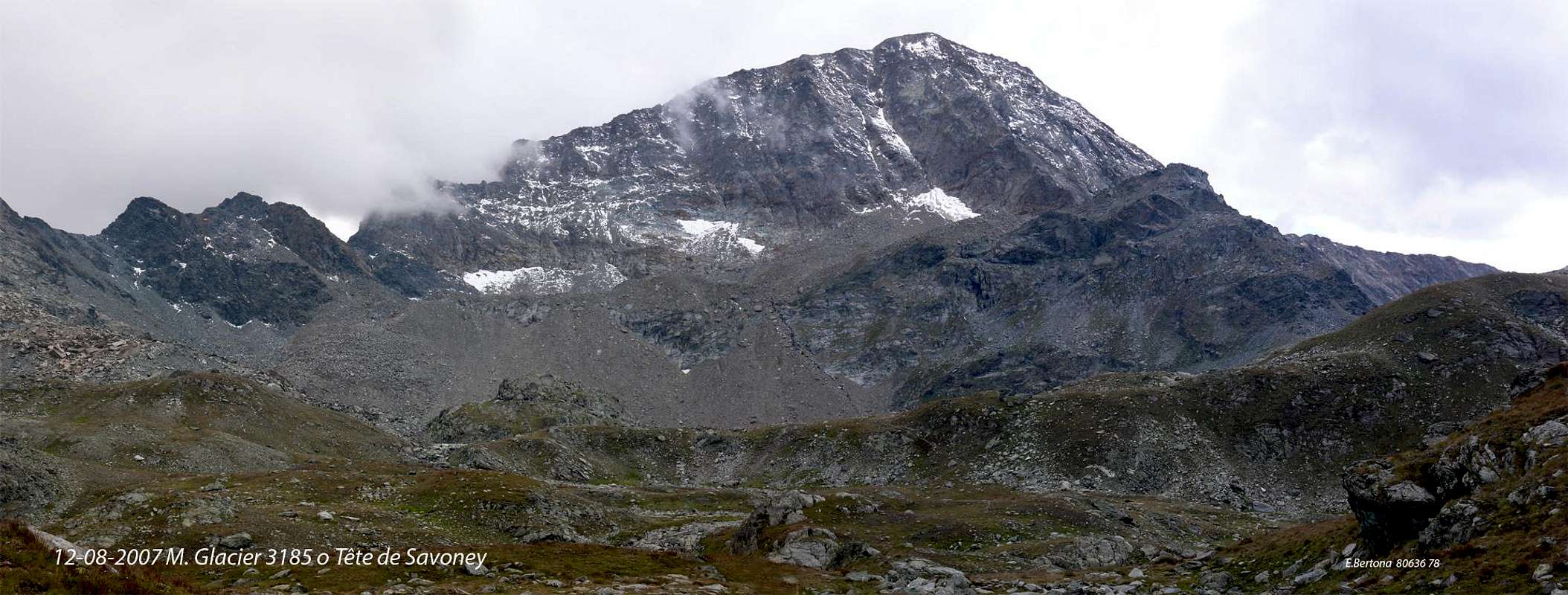
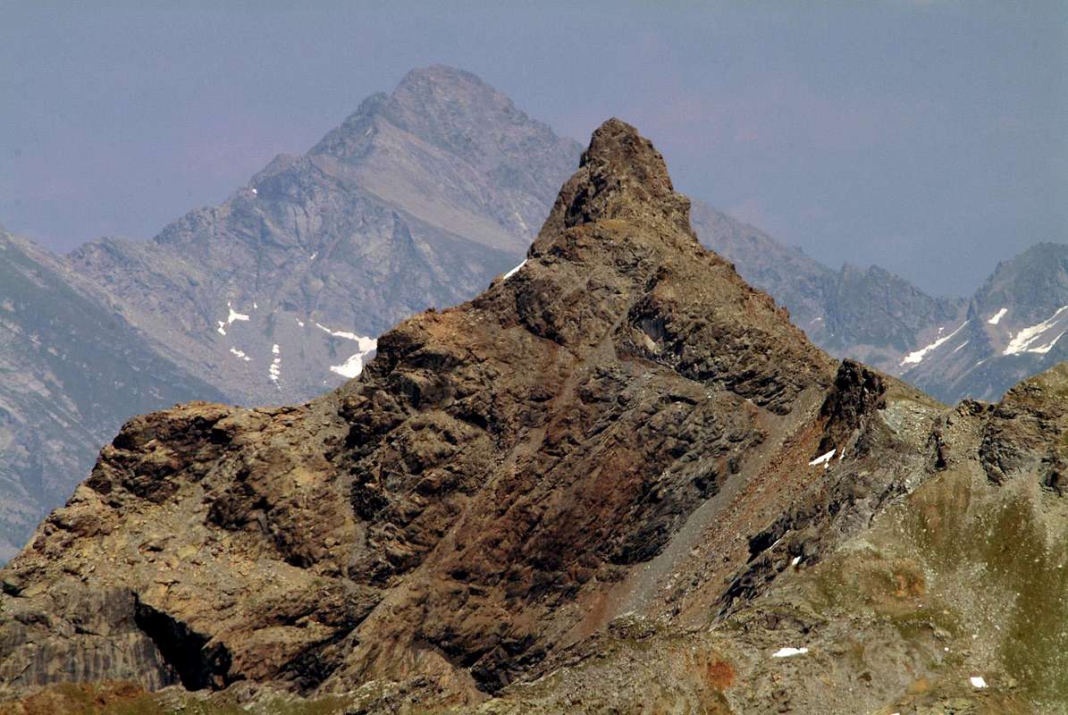
Mount Delà (3139m) above Savoney Walloon in Fénis-Clavalité Valley, with Northwestern View, by emilius
"Above us there is You" by Mimmo Modugno
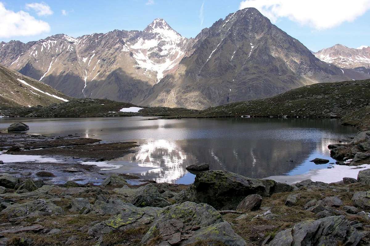
Arriving in Champorcher two mountains are silhouetted in front of the mass of the Mount Glacier and the twin pyramid of Delà hiding behind, but it lets you look. They are emblems of this valley? No, because the highest mountain is the Rosa of Banchi (3164m), hardly in contrast hides in the South and no one sees it. We must continue on the Royal Road to Dondena to be able to admire. A Diva who likes to live hidden in anonymity! Instead Glacier and Delà stand opposite presumptuous, in clash the Glacier requires that little bit of extra height and flaunts asking for respect. So Delà remains there, hidden in the wings.
Mount Delà (3139m)
"The Mont Delà remains hidden behind the Curtain / Il Mont Delà rimane nascosto dietro il Sipario", by Corvus
Nevertheless it emerges on the other side, going from the Walloon Fénis-Clavalité, which immediately visible and dueling with the first. From here the difference is minor and the "fight shoulder to shoulder" is broken only by the depression between the two, the Fussì Hill. In this way the Delà is no longer the Vassal beyond, but the challenge Glacier in an epic duel as much as ever. The old Mount-de-Loing returns to be no longer there, but on this side and raises his crest like a cock before the duel. Then he looks away la Rosa and resizes, then turns his head to the West and the nearby Tersiva sends him back there ...
"From The Summit "falls" towards Lake Ice / Dalla Sommità "cade" verso il Lago Gelato, by emilius
La seconda grande ramificazione si spinge invece verso Oriente e dal Glacier forma i due colli con lo stesso nome della Gran Rossa, il Bocon Damon, la Tete des Hommes, la Torretta e raggiunge i due importanti colli paralleli del Lago Bianco e della Croce, tali da collegare le due Valli di Champdepraz (Rifugio Barbustel appena sotto e a Nord dei medesimi) e di Champorcher. Oltre la cresta si eleva alla Cima Piana (2512 m) dalla quale nuovamente si divide in due rami: uno a Nord verso Mont Grimon, Mont La Pertze e Bec di Nona, all'interno del Parco Naturale del Monte Avic; l'altro invece, più esteso, si allunga a Est-sudest formando Cima Perche, Colle di Terra Rossa, Colle di Brenve, Colle e Punta di Arcomy (1991 m), Bec di Nona, Colle di Possoney, Col de Plan Fenetre, Tete du Mont, Tete Colon, Col Brequet, Mont Charvatton (1787 m; belle ed importanti vie su roccia sana, abbastanza frequentate) per terminare al Col Courtil, tra gli abitati di Pont Bozet e Hone (splendida Fortezza Napoleonica, da poco tempo restaurata).
 |
PREMESSA
Effettuata questo doveroso preambolo, onde fare comprendere il collocamento nonché il giusto rapporto, tra le catene montuose, v'é da evidenziare come questa Seconda Parte di Curtain XI° dev'esser a sua volta in due ben distinte aree:
1)-: la prima analizzante tutte le montagne più rivolte ad Est, cioé dalla Torre Pontonnet al Glacier ed alle ramificazioni di cui sopra. Questo settore contiene tutte la catene a Settentrione del Torrent Ayasse, che, a sua volta, risulta divisorio in due parti della Valle di Champorcher; tutti questi valloni "cadono" perpendicolarmente verso il Fiume Dora Baltea e quindi verso l'asse centrale della Valle di Aosta nella zona Media ed in quella Bassa.
2)-: la seconda, momentaneamente "ospitata", almeno nei titoli, in questa, riguarda le montagne a Sud della Rosa dei Banchi e, quindi, situate più verso Sudest; queste formano valloni discendenti in perpendicolare verso il Torrent Ayasse, quindi verso i Comuni di Champorcher e Pont-Bozet. Più ad Est altri valloni calano, selvaggi, precipitando verso l'asse centrale in direzione dei Comuni di Bard, Donnas e Pont Saint Martin, in quella che vien definita in loco Bassa Valle. Di questa altresì vasta area, della quale tratteremo nella Terza Parte di Curtain XI°, s'evidenzia la montagna più elevata nonché conosciuta, ossia la Rosa dei Banchi (3164 m). Insieme al Mont Glacier formano l'Emblema della Valle di Champorcher.
Anche di questi due settori, Est e Sudest, parleremo, logicamente non essendo questi l'obiettivo più proprio d'una guida alpinistica, non di tutti i monti ma d'alcuni d'essi che, o per peculiarità e caratteristiche storiche, toponomastiche e topografiche o semplicemente perché legate a ricordi di personali ascensioni, maggiormente hanno stimolato la Fantasia.
 |
Mont Delà: beyond of what?
Arriving in Champorcher two mountains are silhouetted in front of the mass of the Mount Glacier and the twin pyramid of Delà hiding behind, but it lets you look. They are emblems of this valley? No, because the highest mountain is the Rosa of Banchi (3164m), hardly in contrast hides in the South and no one sees it. We must continue on the Royal Road to Dondena to be able to admire. A Diva who likes to live hidden in anonymity! Instead Glacier and Delà stand opposite presumptuous, in clash the Glacier requires that little bit of extra height and flaunts asking for respect. So Delà remains there, hidden in the wings.
"The Mont Delà remains hidden behind the Curtain / Il Mont Delà rimane nascosto dietro il Sipario", by Corvus
 |
Nevertheless it emerges on the other side, going from the Walloon Fénis-Clavalité, which immediately visible and dueling with the first. From here the difference is minor and the "fight shoulder to shoulder" is broken only by the depression between the two, the Fussì Hill. In this way the Delà is no longer the Vassal beyond, but the challenge Glacier in an epic duel as much as ever. The old Mount-de-Loing returns to be no longer there, but on this side and raises his crest like a cock before the duel. Then he looks away la Rosa and resizes, then turns his head to the West and the nearby Tersiva sends him back there ...
 |
Arrivando in Champorcher due montagne si staglian di fronte: la massa del Mont Glacier e la piramide gemella del Delà che si nasconde dietro, ma lasciandosi osservare. Son gli emblemi di questa vallata? No, perché la montagna più alta é la Rosa dei Banchi (3164 m), quasi in contrasto si nasconde a Mezzogiorno e nessun la vede. Bisogna proseguire sulla Strada Reale verso Dondena onde poterla ammirare. 'Na Diva alla quale piace vivere nascosta nell'anonimato! Invece Glacier e Delà s'ergon presuntuosi dirimpetto, ma il Glacier impone quel pò di altezza in più e la ostenta chiedendo il dovuto rispetto. Così il Delà rimane al di là, nascosto tra le quinte.
Mount Delà Standard Route from Fussì Pass (2912m), with North-northwestern View, by emilius
Però emerge dall'altra parte, salendo dal Vallone di Fénis-Clavalité, mettendosi subito in vista e duellando col primo. Da qui la differenza é minore e la "lotta spalla a spalla" é rotta soltanto dalla depressione, tra i due, del Col Fussì. In siffatto modo il Delà non é più il Vassallo al di là, bensì sfida il Glacier in un duello tanto epico quanto eterno. L'antico Mont-de-Loing ritorna ad essere non tanto più di là, ma di qua ed innalza la cresta come un gallaccio prima del duello. Poi guarda lontano la Rosa e si ridimensiona, eppoi gira la testa ad Occidente e la vicina Tersiva lo manda di nuovo di là ...
The Monte thawed
 |
Però emerge dall'altra parte, salendo dal Vallone di Fénis-Clavalité, mettendosi subito in vista e duellando col primo. Da qui la differenza é minore e la "lotta spalla a spalla" é rotta soltanto dalla depressione, tra i due, del Col Fussì. In siffatto modo il Delà non é più il Vassallo al di là, bensì sfida il Glacier in un duello tanto epico quanto eterno. L'antico Mont-de-Loing ritorna ad essere non tanto più di là, ma di qua ed innalza la cresta come un gallaccio prima del duello. Poi guarda lontano la Rosa e si ridimensiona, eppoi gira la testa ad Occidente e la vicina Tersiva lo manda di nuovo di là ...
Paradoxical! The Mount Glacier (= iced) bubbles under the Greenhouse Effect
The Greenhouse effect is greatly Fashionable and Mount Glacier that, even if he lives between two mountain valleys, do not want to know to stay out of the time and especially the news. As it happens to all "Alpigiani" who go to a big City, he also wants to be duped by the Media. "Enough with all this snow on me it makes me feel cold moving away from Life. I have put on so much that I ended up being called Frozen. Instead I feel hot and perky. Ready to live great adventures. 'm Tired of this to quarrel with dwarf the Delà to be the most beautiful of the Village, that is a small mountain village. Then beyond, to the North in Clavalité Walloon, I do not know anyone Everyone goes to Grand Alpe to buy herself the Fontina cheese, salt, or someone to Tersiva Point. Few others climb upward Fénis Hill to go in Cogne or Champorcher Valleys, but not even turn his head. 'M old, freezing cold and not interested in anyone. Indeed there, in the Walloon of the Lakes, where I explain my rough walls above the Grand Lake I 've heard someone exclaim: but as the name of that mountain there? A Nerd! I make my makeup, I get rid of the snow and Glacier is just the name, or rather the nickname."
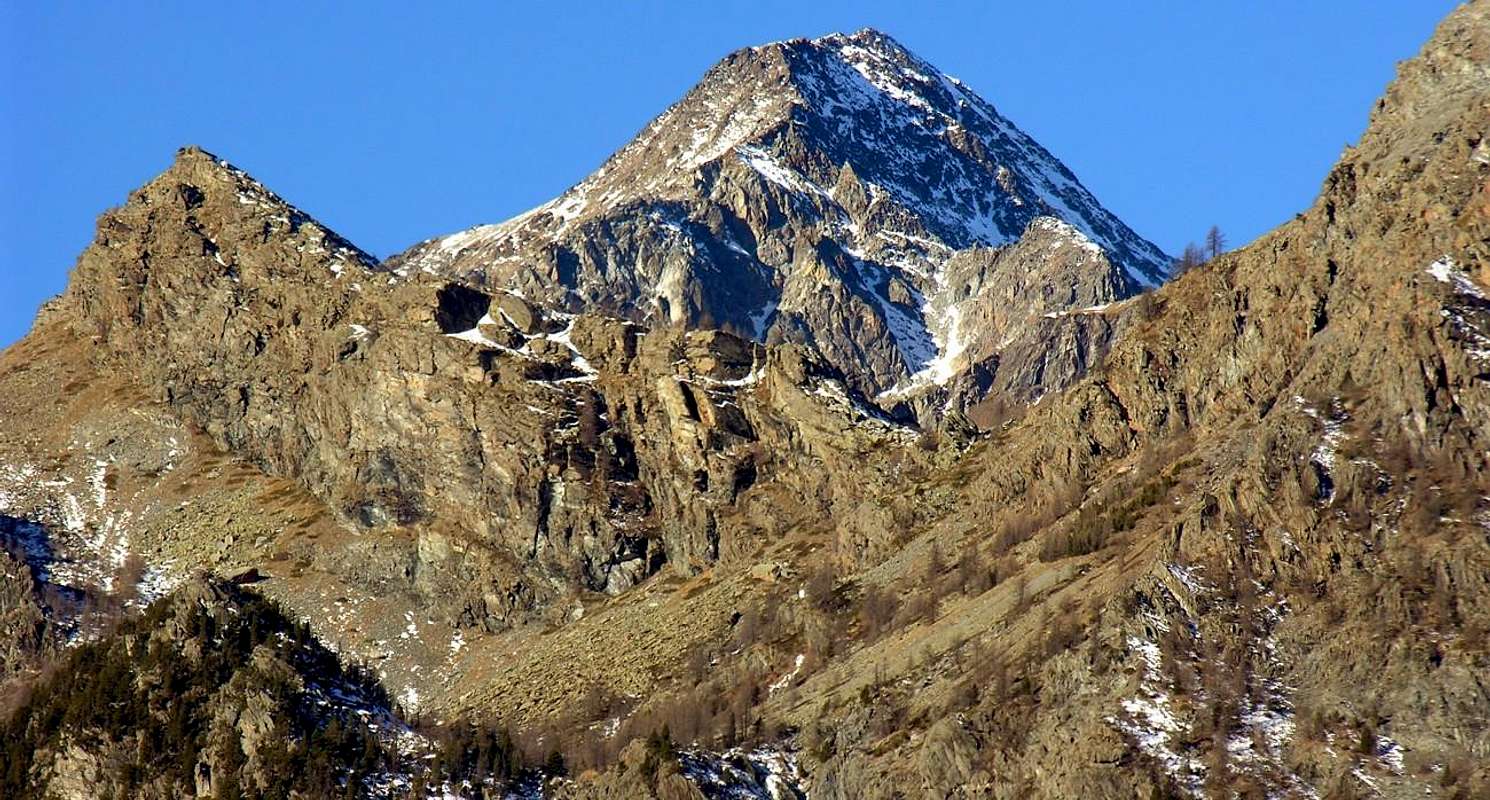
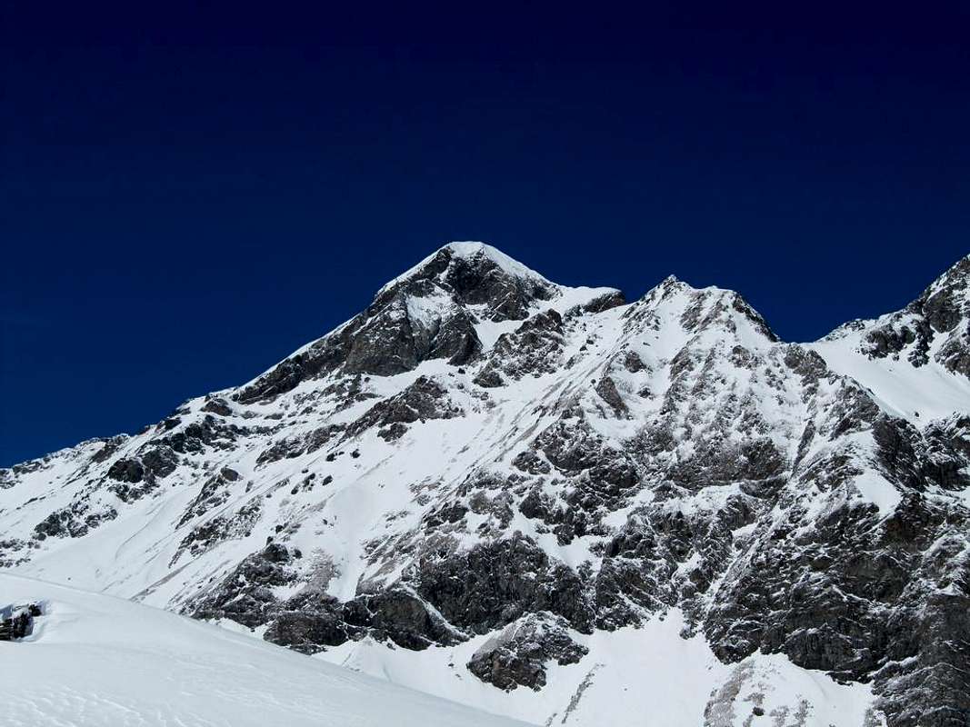
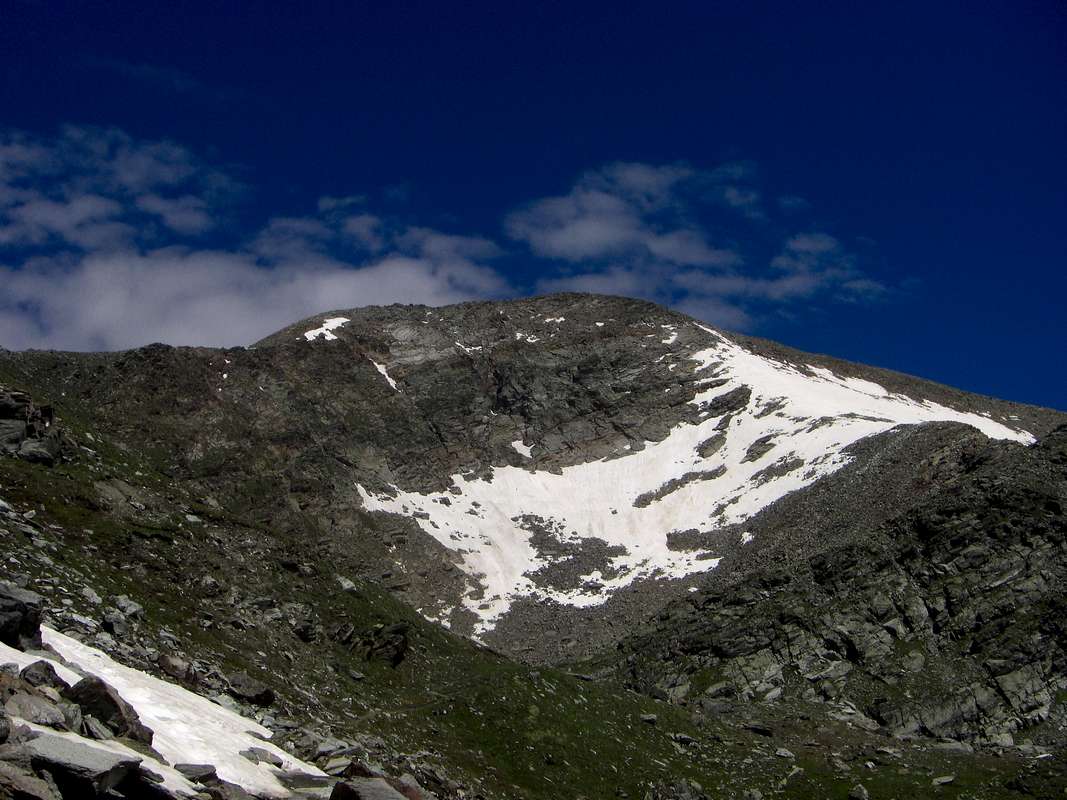
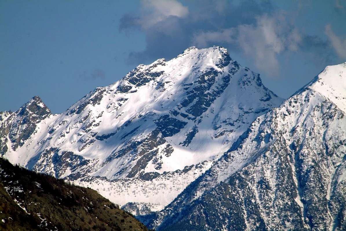
Mount Glacier (3186m)
The MOUNT GLACIER (3186m) with East-southeastern View & from left: Southwest Ridge from Fussì Pass, Sout-southwest Slope or Standard Route, East Face, East Ridge to Great Rossa Hills, Northeast Wall & North Edge to Medzove Pass,
by emilius.
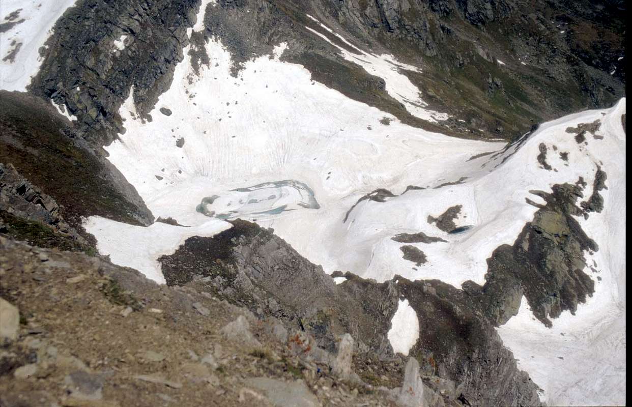
So to be more IN the Glacier began to strip
originating in South a little beautiful blue lake, but he remained nameless, as the Glacier had refused her and he felt Son of None. Other than the Greenhouse Effect! But how many tales we tell ...
Mount Glacier Standard Route, with Southwestern View, by Corvus
The MOUNT GLACIER (3186m) with East-southeastern View & from left: Southwest Ridge from Fussì Pass, Sout-southwest Slope or Standard Route, East Face, East Ridge to Great Rossa Hills, Northeast Wall & North Edge to Medzove Pass,
by emilius.
 |
So to be more IN the Glacier began to strip
originating in South a little beautiful blue lake, but he remained nameless, as the Glacier had refused her and he felt Son of None. Other than the Greenhouse Effect! But how many tales we tell ...
 |
L'effetto Serra va di gran Moda ed il Mont Glacier che, anche se vive tra due vallate di montagna, non vuol saperne di restar tagliato fuori dai tempi e soprattutto dalle novità. Come succede a tutti gli Alpigiani che si recan in una grande Città, anche lui vuole farsi turlupinare dai Media. "Basta con tutta questa neve addosso che m'infreddolisce allontanandomi dalla Vita. Me ne han messa addosso così tanta ch'ho finito per essere denominato Ghiacciato. Io invece mi sento caldo e pimpante. Pronto a vivere grandi Avventure. Sono stanco di baruffare con sto Nanetto del Delà per essere il più bello del Villaggio, cioè d'un paesin di montagna. Poi di là, verso Settentrione in Clavalité, non mi conosce nessuno. Tutti van a Grand Alpe a comprarsi la Fontina, oppur qualcuno sale alla Tersiva. Pochi altri van sù al Col Fénis per andare in quel di Cogne o Champorcher, ma non giran nemmen testa. Son vecchio, freddo e gelato e non interesso più a nessuno. Anzi di là, nel Vallone dei Laghi, dov'espongo le mie ruvide pareti sopra il Gran Lago, ho già sentito qualcuno esclamare: ma come si chiama quella montagna lì? Una Nullità! Mi rifaccio il trucco, mi sbarazzo delle nevi e del Glacier rimane solo il nome, anzi il nomignolo".
Mount Glacier North (right) & North-northeast Faces, with Northern View, by emilius
Desiderando d'esser più IN iniziò a spogliarsi
originando a Sud un bel laghetto azzurro, che però rimase senza nome, poiché il Glacier aveva ricusato il suo e lui si sentiva Figlio di Nessuno. Altro ch'Effetto Serra! Ma quante balle ci contan sù ...
HUuuuunters's King
 |
Desiderando d'esser più IN iniziò a spogliarsi
originando a Sud un bel laghetto azzurro, che però rimase senza nome, poiché il Glacier aveva ricusato il suo e lui si sentiva Figlio di Nessuno. Altro ch'Effetto Serra! Ma quante balle ci contan sù ...
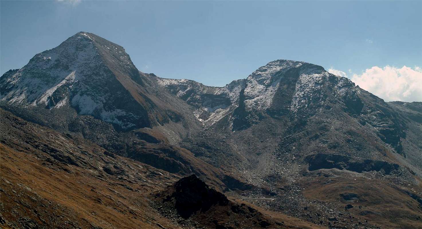
Mont Raf (f) re(a)y the Hunting Nature Preservoir "reserved" by Vittorio Emanuele I°, First King of Italy
Everyone knew that the Mont Rafrey has a complicated name: Rafrey or Raffrey, and still Refrey or Reffrey? Ie upstream cooled, who is suffering from this disease because the neighbor and higher Glacier steals the sun. Summer's all right, but in winter it is a big problem. The sun always comes late and in smaller quantities. Easy to say, but "our" in the bad weather is likely to die of pneumonia. In the Summer, however, was also "King Toio1 upward with its Keeper. Hunting of Ibex.
Mount Raf(f)re(a)y (3146m) & Bec de Viot (3051m)
"Re "Toio" he built a muletrack to hunt on his favorite mountain ... / Re "Toio" si fece costruir 'na mulattiera per andar caccia sulla sua montagna preferita ...", by emilius
He also built a trail-muletrack, or nearly so. The noises of the Hunt and the sound of horns filled the Walloons. Then all declined in the Darkness of Time, and the Rafrey continued to have a cold.
As a little little woman sneezing to every cloud that passed over. He remained on the back burner for men. Above the Alp of th'Etsely Damon ...
Raffrey & Margheron Lake from Mount Glacier (3186m), with Southern View, by emilius
 |
He also built a trail-muletrack, or nearly so. The noises of the Hunt and the sound of horns filled the Walloons. Then all declined in the Darkness of Time, and the Rafrey continued to have a cold.
As a little little woman sneezing to every cloud that passed over. He remained on the back burner for men. Above the Alp of th'Etsely Damon ...
 |
Tutti lo sapean ch'el Mont Rafrey ha nome complicato: Rafrey o Raffrey, oppure ed ancora Refrey o Reffrey? Cioé monte raffreddato, sofferente di questa malattia perché il vicino e più elevato Glacier gli rubacchia il sole. D'Estate va tutto bene, ma in Inverno é un bel problema. Arriva tardi e sempre in minor quantità. Facile a dire, ma il "nostro" nella cattiva stagione rischia di morir di polmonite. Nella bella invece anche "Re Toio" andava sù coi suoi Guardiacaccia. A caccia dello Stambecco.
Raffrey & Roèses Range from Mount Glacier, with South-southeastern View, by emilius
Si fece costruire anche una mulattiera, o quasi. I rumori della Caccia riempivan Valloni. Poi tutto decadde nel Buio del Tempo, ed il Rafrey continuò ad avere il raffreddore.
Come una donnicciuola starnutiva ad ogni nuvoletta che gli passava sopra. Rimase nel dimenticatoio degli uomini. Sopra l'Alpe dell'Etsely Damon ...
"Wandering", by emilius
A bit lost in the woods of the high walloons
 |
Si fece costruire anche una mulattiera, o quasi. I rumori della Caccia riempivan Valloni. Poi tutto decadde nel Buio del Tempo, ed il Rafrey continuò ad avere il raffreddore.
The Arcomy Point (1991m), it is not Everest, but it is likeable
 |
Do you remember when young people dreamed of Mount Everest? There were no photos. We knew it was only 8848 meters high. It as a great ice cream, which touched the sky. Then came the first photographs, followed by others. But yeah, it was like the Mount Blanc even less. A large pyramid that rose to the sky. A sky certainly very cold. Incidentally here men living at 5000 meters, two hundred feet above the Mount Blanc. In the proportions everything returns to normal.
Instead, the Arcomy Point is a big problem: no one knows where it is. You Champorcher parts from the villages below and go upwards, then turn right towards East. But I do not know where to go. How to Mount Everest, where carriers crossing mountain glaciers barefoot, so you climb into the unknown where they go to cut wood. Then you arrive. In the middle of the woods, just above its hill. But you seem to have reached the Everest. Why is the mystery of what fascinates ...
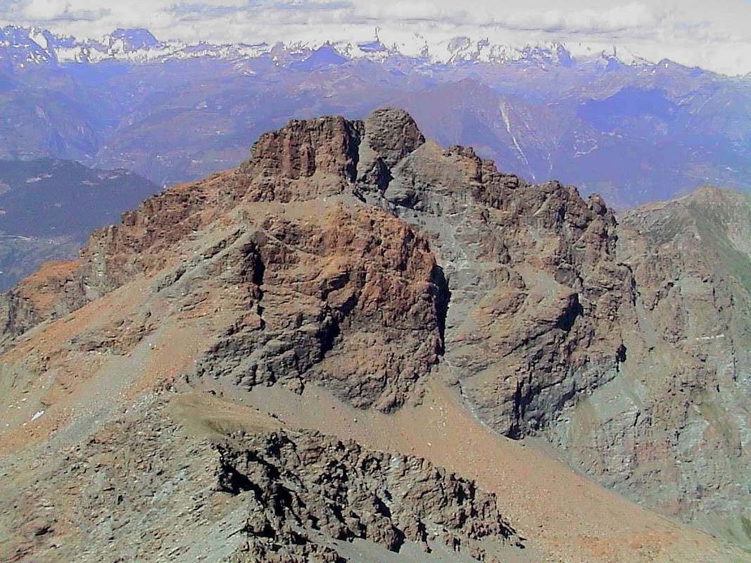
Arcomy Hill (1952m) & Point (1991m)
It is not EVEREST
"Desolate & abandonated Tops", by emilius
A bit lost in the woods of the high walloons
Vi ricordate quando da giovani sognavam l'Everest? Non esistevan foto. Solamente sapevamo che era alto 8848 metri. Lo immaginavi come un grande gelato, che toccava il cielo. Poi vennero le prime fotografie, seguite da altre. Ma si, era come il Monte Bianco, anche meno. Un piramidone che saliva al cielo. Un cielo sicuramente molto freddo. Daltronde qui gli uomini abitano a 5000 metri; duecento metri sopra il Bianco. Nelle proporzioni tutto ritorna alla normalità.
Invece la Punta d'Arcomy é un bel problema: nessuno sa dove sia. Tu parti dai villaggi sotto Champorcher e vai sù, poi giri a destra verso Oriente. Ma non sai dove vai. Come per l'Everest, dove i portatori di montagna attraversano i ghiacciai a piedi scalzi, così tu sali nell'incognito dove loro van far legna. Poi arrivi. In mezzo ai boschi, appena sopra il suo colle. Ma ti sembra d'aver raggiunto l'Everest. Perché é il Mistero ciò che affascina ...
It is not EVEREST
"Somewhere we go ... / Da qualche parte andremm ... ", by emilius
Copper&IronMiners
Instead, the Arcomy Point is a big problem: no one knows where it is. You Champorcher parts from the villages below and go upwards, then turn right towards East. But I do not know where to go. How to Mount Everest, where carriers crossing mountain glaciers barefoot, so you climb into the unknown where they go to cut wood. Then you arrive. In the middle of the woods, just above its hill. But you seem to have reached the Everest. Why is the mystery of what fascinates ...
It is not EVEREST
 |
Vi ricordate quando da giovani sognavam l'Everest? Non esistevan foto. Solamente sapevamo che era alto 8848 metri. Lo immaginavi come un grande gelato, che toccava il cielo. Poi vennero le prime fotografie, seguite da altre. Ma si, era come il Monte Bianco, anche meno. Un piramidone che saliva al cielo. Un cielo sicuramente molto freddo. Daltronde qui gli uomini abitano a 5000 metri; duecento metri sopra il Bianco. Nelle proporzioni tutto ritorna alla normalità.
Invece la Punta d'Arcomy é un bel problema: nessuno sa dove sia. Tu parti dai villaggi sotto Champorcher e vai sù, poi giri a destra verso Oriente. Ma non sai dove vai. Come per l'Everest, dove i portatori di montagna attraversano i ghiacciai a piedi scalzi, così tu sali nell'incognito dove loro van far legna. Poi arrivi. In mezzo ai boschi, appena sopra il suo colle. Ma ti sembra d'aver raggiunto l'Everest. Perché é il Mistero ciò che affascina ...
It is not EVEREST
 |
The Mount Avì or Avic also Aù, carved by Miners
They said that as a young
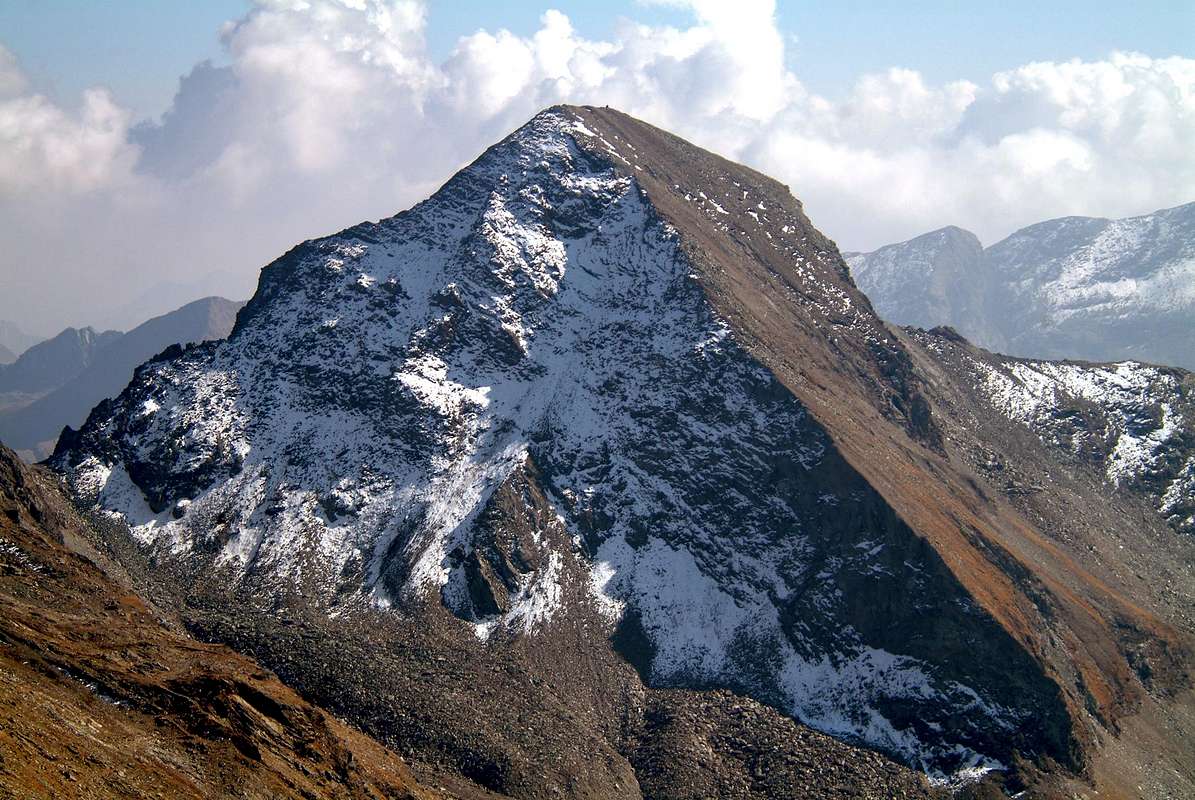
Mount Avic was not so nice, slim and slender like an arrow against the sky. Instead, it was a little fat and plump to force feed themselves by eating iron from morning to evening. He was a glutton who kept everything to himself and looked down the valley with sleepy eyes. On the other hand no one admired him nor from a distance or up close that is to Verrès above which stands today admired by all. In fact it has become the symbol of this little town. The famous Amicare Crétier (* 1909 + Verres Matterhorn 1933) elected him as favorite mountain, even more Wanda (North of the Grandes Jorasses ) which aspired yet. Could hardly escaped upward, with his young Friends, or just doing laps cyclopean, as when, returning from the Rosa of Banchi, rising from the valley floor during the day and traveled throughout the long Champorcher Valley was then dropped for Urtier Walloon in Cogne Valley and from there to Aosta Town. Everything is walking distance to sixty miles and more. He was spared only the stretch from Aosta to Verrès with about thirty miles by the train. But when he could Amilcare came and went always to the Mount Avic. Always logically walk from Verrès with almost 3000 meters of altitude upwards and the same down. Logically always the same day. There he refreshed his rebel Spirit and his Soul. But in those days the Mount Avic had already become beautiful with a silhouette worthy of a wearer.
Mount Avìc (3006m)
Mount Avic Northern Standard Route, with Northeastern View, by Corvus
Mount Avic was not so nice, slim and slender like an arrow against the sky. Instead, it was a little fat and plump to force feed themselves by eating iron from morning to evening. He was a glutton who kept everything to himself and looked down the valley with sleepy eyes. On the other hand no one admired him nor from a distance or up close that is to Verrès above which stands today admired by all. In fact it has become the symbol of this little town. The famous Amicare Crétier (* 1909 + Verres Matterhorn 1933) elected him as favorite mountain, even more Wanda (North of the Grandes Jorasses ) which aspired yet. Could hardly escaped upward, with his young Friends, or just doing laps cyclopean, as when, returning from the Rosa of Banchi, rising from the valley floor during the day and traveled throughout the long Champorcher Valley was then dropped for Urtier Walloon in Cogne Valley and from there to Aosta Town. Everything is walking distance to sixty miles and more. He was spared only the stretch from Aosta to Verrès with about thirty miles by the train. But when he could Amilcare came and went always to the Mount Avic. Always logically walk from Verrès with almost 3000 meters of altitude upwards and the same down. Logically always the same day. There he refreshed his rebel Spirit and his Soul. But in those days the Mount Avic had already become beautiful with a silhouette worthy of a wearer.
Mount Avic Northern Standard Route, with Northeastern View, by Corvus
 |
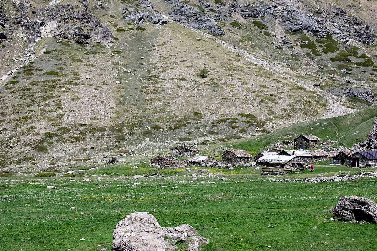
When they had seen him for the first time the Miners , were forced to go to work, their life on the shores of Lake Frozen was instead all else. They decided, on holidays or after work hours, since there was no Television, Radio and even Newspapers and had to stay there in Summer as in Winter by sending downstream ore by Mule or by pushing down the Big Slides, switch free time doing the Sculpture. They gave their picks with Art and began to shape the Mount Avic. A tough job, too, and great Patience. But they were trained with arms and adapted with the mind to great sacrifices that required great patience. Sculpted, carved, sculpted for Centuries. How many? No one knows, because the Mines were exploited by Salassians before the arrival of the Romans. First sculpted in the East on that great wall above the trail above the Creek Chalamy, where passing day. And while the Avic changed appearance, they were joyful and happy with their Creature. Then he turned to Face North, one facing the valley floor and everyone can see through the Valley of Aosta. But they offered, as a Grand Dame, that you do want, for a short time: a fleeting moment while transits to Verrès, because immediately took refuge behind the scenes. To the West made drafts the thickest part but it did not take long, because there just looking at the Avic see it from afar. It remained for the last part of the South, one facing the Mount Iverta, to Th'Invers Frozen Loch and their Mining and Barracks. They did not put the time in hand, as the same were suddenly closed. An incomplete work like those of Michelangelo, but always a Great Work. So the Mount Avic disposed of quite a bit of iron from her womb, showed up with a New Look and was locally called the Monte Au, ie the Mount Sharp also, better and better, Acute and Au said to contraction. But not everyone knows that ...
Soubgroup L'Invers of Frozen Loch, Mount Avic & Mount Rouvic, with Northeastern View, by emilius
 |
Contan che giovanotto il Monte Avic non fosse così bello, snello e slanciato come freccia contr'al cielo. Era invece grassotello e paffuto a forza di nutrirsi ingoiando ferro da mane a sera. Era 'n'ingordo che teneva tutto per se stesso e guardava verso valle con sguardo sonnolente. Per contro nessun l'ammirava, né da lontano come da vicino, cioé da Verrès sopra il quale oggi svetta goduto da tutti. Anzi n'é diventato il simbolo. Di questa piccola Città. Il celebre Amicare Crétier (* Verrès 1909 + Cervino 1933) l'aveva eletto come montagna preferita, ancor più che la Wanda (Nord delle Jorasses) alla quale eppur ambiva. Appena poteva scappava sù, coi suoi giovani Amici o da solo effettuando giri ciclopici, come quando, tornando dalla Rosa dei Banchi, salita in giornata dal fondovalle e percorsa tutta la lunga Valle di Champorcher era poi sceso per il Vallone dell'Urtier in Cogne donde ad Aosta. Tutt'a piedi per 'na sessantina di Kilometri ed anche più. S'era risparmiato solo il tratto da Aosta a Verrès con una trentina di Kilometri in treno. Ma quando lo poteva Amilcare andava e ritornava sempre al Monte Avic. Sempre logicamente a piedi da Verrès con quasi 3000 metri di dislivello in sù ed altrettanti giù. Logicamente sempre in giornata. Lì ristorava il suo Spirito ribelle e la sua Anima. Ma a quei tempi il Monte Avic era di già divenuto bello con una silhouette degna d'indossatore.
Mount Avic Standard Route from South, with South-southwestern View, by emilius
Quando l'avevan visto per la prima volta i Minatori
, costretti a passare, per il lavoro, la loro vita sulle sponde del Lago Gelato era invece tutta 'n'altra cosa. Decisero così, nei giorni festivi o nelle ore di dopolavoro, visto che non esistevano Televisione, Radio e nemmeno i Giornali e lì dovevano stare in Estate come d'Inverno mandando a valle il minerale coi Muli o spingendolo dabbasso tramite gli Slittoni, di passar tempo libero scolpendo. Si diedero all'Arte e con i loro picconi incominciarono a modellar l'Avic. Un duro lavoro, pur questo, e di gran Pazienza. Ma eran allenati con le braccia e adattati con la mente a grandi sacrifici richiedenti ste qualità. Scolpirono, scolpiron, scolpiron per Secoli. Quanti? Non é dato a sapersi, perché le Miniere eran sfruttate dai Salassi ancor prima dell'arrivo dei Romani. Dapprima scolpiron ad Oriente su quella grande parete che sovrasta la mulattiera sopra il Torrente Chalamy, dove transitavano quotidianamente. E mentre l'Avic cambiava aspetto, eran gioiosi e felici della loro Creatura. Poi si rivolsero alla Faccia Nord, quella che guarda il fondovalle e che tutti posson mirar passando per la Valle di Aosta. Ma la offrirono, come Gran Dama, che si fa desiderare, per poco tempo: un attimo fuggente mentre transiti per Verrès, perché subito si sconde dietro le quinte. Ad Ovest sbozzarono la parte più grossolana ma non v'impiegarono molto, perché lì l'Avic lo vedi soltanto da lontano. Rimaneva buon ultima la parte Sud, quella rivolta al Monte Iverta, all'Invers del Lago Gelato ed alle loro Miniere e Baracche. Non fecero tempo mettervi mano, poiché le stesse vennero d'improvviso chiuse. Un opera incompleta come quelle del Michelangelo, ma sempre 'na Grande Opera. Così il Monte Avic, smaltito un bel pò di ferro dal suo ventre, si presentò con un nuovo Look e venne chiamato in loco il Monte Au, cioé il Monte Acuto, contratto in Au. Ma non tutti san ciò ...
The Mount Back or Behind / La sconosciuta e selvaggia Faccia Ovest
" The North Face unfamiliar and wild / La sconosciuta Faccia Occidentale", by emilius
 |
Quando l'avevan visto per la prima volta i Minatori
, costretti a passare, per il lavoro, la loro vita sulle sponde del Lago Gelato era invece tutta 'n'altra cosa. Decisero così, nei giorni festivi o nelle ore di dopolavoro, visto che non esistevano Televisione, Radio e nemmeno i Giornali e lì dovevano stare in Estate come d'Inverno mandando a valle il minerale coi Muli o spingendolo dabbasso tramite gli Slittoni, di passar tempo libero scolpendo. Si diedero all'Arte e con i loro picconi incominciarono a modellar l'Avic. Un duro lavoro, pur questo, e di gran Pazienza. Ma eran allenati con le braccia e adattati con la mente a grandi sacrifici richiedenti ste qualità. Scolpirono, scolpiron, scolpiron per Secoli. Quanti? Non é dato a sapersi, perché le Miniere eran sfruttate dai Salassi ancor prima dell'arrivo dei Romani. Dapprima scolpiron ad Oriente su quella grande parete che sovrasta la mulattiera sopra il Torrente Chalamy, dove transitavano quotidianamente. E mentre l'Avic cambiava aspetto, eran gioiosi e felici della loro Creatura. Poi si rivolsero alla Faccia Nord, quella che guarda il fondovalle e che tutti posson mirar passando per la Valle di Aosta. Ma la offrirono, come Gran Dama, che si fa desiderare, per poco tempo: un attimo fuggente mentre transiti per Verrès, perché subito si sconde dietro le quinte. Ad Ovest sbozzarono la parte più grossolana ma non v'impiegarono molto, perché lì l'Avic lo vedi soltanto da lontano. Rimaneva buon ultima la parte Sud, quella rivolta al Monte Iverta, all'Invers del Lago Gelato ed alle loro Miniere e Baracche. Non fecero tempo mettervi mano, poiché le stesse vennero d'improvviso chiuse. Un opera incompleta come quelle del Michelangelo, ma sempre 'na Grande Opera. Così il Monte Avic, smaltito un bel pò di ferro dal suo ventre, si presentò con un nuovo Look e venne chiamato in loco il Monte Au, cioé il Monte Acuto, contratto in Au. Ma non tutti san ciò ...
The Mount Ruvi, Rouvic or Revì also Revic, ie upside down, ie behind
" The North Face unfamiliar and wild / La sconosciuta Faccia Occidentale", by emilius
 |
The Mont Ruvi, so it appears in the recent maps and guide "Emilius Rosa dei Banchi Parco del M. Avic" by Giulio Berutto and Lino Fornelli ; Edit. C.A.I ./T.C.I . 2005 pages 261/2, and small topographic map, is smaller twin of the nearby Mount Avic or Au (3006m). Like his older brother likes to change the name in a fratricidal competition due to a little Envy and a little Jealousy: "Ah yes, if you think you are the most beautiful and the most cunning only because you're only eighty meters high over me and you boast of having three names, you know what I do? for the height I can not do anything because it wanted to Mama Nature but as far as I have three of them if you give me four: Ruvi for scholars, Revi for local residents, as well Revic because I want to have the letter c that makes so chic and Rouvic for mass, so that confuses us and do not understand anything". So he thought and did dismaying & consternating Men and Ideas. Not that B&V in their "Guide to the Western Alps", page 112; Edit. Turin in 1896 by the Section of the C.A.I. were clear: AVI for greater and Revi, without an accent, for Vassal. Taken from this confusion Mario Aldrovandi dismissed them both, in his Guide "Guide Autonomous Region of Aosta Valley", page 194 ; Edit. Lattes Turin 1930/2, with a line and a half talking about the Valley Clavalité : "At the Mount Avic (m 3006, 5 hours). Summit overview. It is located between the Varotta Hill and the Reje of Chevrère". And nothing more. He would not hear of family quarrels and second, that our in question did not mention even the name. Times were hard & exclusive and the revolutionaries did not like their own. Avic's all!!! But the Ruvi, stubborn, did not give in and wanted to overcome Honorary Titles and Noble's older brother. He made such a mess that the climbers did not understand anything anymore. End result? There is almost no one left. Not for the length of the Long Approaches, but because one goes in Mountain Sunday to enjoy a little of Peace and Tranquility and did not really want to see two brothers in a fist fight with each other for petty reasons ...
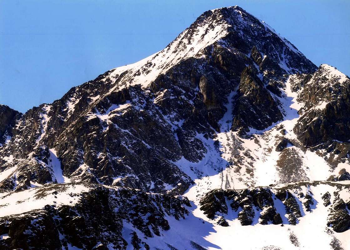
Mount Ruvi or Rouvic also Revì and still or otherwise Revic (2922m)
Mount Revì Standard Route from Varotta Pass (2589m), with South-southwestern View, by emilius
But perhaps revic with the radical re, as to reply as a replica, wants to mean behind, which is the mountain that is behind another mountain, like Mount Paramont means mountain sheltering another mountain. Ie a mountain hidden or preceded by a second upstream. And then is the fate of Ruvi have always ahead of the South Mount Avic. He will be sadly for Eternity Mount Behind. Below the Mount Avic, although not many meters, is the highest and most important to him. However, even if very little frequented, it remains a beautiful, powerful, ancient and wild mountains. The move is admired in the West Valley of Aosta, or standing on her balconies in the South of Baltea Stream. Not difficult, but never trivial climb, raises his crests and walls burned and baked by the sun and swept by the winds of the North and broken by winter ice over his rough walloons on the edge of the Natural Park of Mount Avic. For its features, if you look at the photos, it could easily be in the Grand Canyon. Who is the Genius that the transplanted here?
That ruvi or revic definitely comes from miners in remote ages now, here were at home and on these landmarks regulating their sad and harsh reality.
Mount Rouvic from Varotta Pass (2589m), with Southern View, by emilius
Mount Revì Standard Route from Varotta Pass (2589m), with South-southwestern View, by emilius
 |
But perhaps revic with the radical re, as to reply as a replica, wants to mean behind, which is the mountain that is behind another mountain, like Mount Paramont means mountain sheltering another mountain. Ie a mountain hidden or preceded by a second upstream. And then is the fate of Ruvi have always ahead of the South Mount Avic. He will be sadly for Eternity Mount Behind. Below the Mount Avic, although not many meters, is the highest and most important to him. However, even if very little frequented, it remains a beautiful, powerful, ancient and wild mountains. The move is admired in the West Valley of Aosta, or standing on her balconies in the South of Baltea Stream. Not difficult, but never trivial climb, raises his crests and walls burned and baked by the sun and swept by the winds of the North and broken by winter ice over his rough walloons on the edge of the Natural Park of Mount Avic. For its features, if you look at the photos, it could easily be in the Grand Canyon. Who is the Genius that the transplanted here?
That ruvi or revic definitely comes from miners in remote ages now, here were at home and on these landmarks regulating their sad and harsh reality.
 |
Il Mont Ruvi, almen così appar nella recente cartografie e nella Guida "Emilius Rosa dei Banchi Parco del M. Avic" di Giulio Berutto e Lino Fornelli; Edit. C.A.I./T.C.I. 2005, pagine 261/2 e cartina topografica, é gemello minore del soprastante Monte Avic o Au (3006 m). Come il suo fratello maggiore ama cambiarsi il nome in una competizione fratricida dovuta un poco all'Invidia ed un pò alla Gelosia: "Ah si, se tu ti credi d'esser il più bello e furbo solamente perché sei alto soltanto ottantaquattro metri più di me e te la tiri d'aver tre nomi, sai cosa fò io? Per l'altezza non posso far gnente perché così ha voluto la Mamma Natura, ma per quanto riguarda il nome se tu n'hai tre io me ne dò quattro: Ruvi per gli studiosi, Revi per i paesan, Revic perché pur io voglio aver quella bella c che fà tanto chic e Rouvic per la massa, che così ci e si confonde e non capisce più un tubo!". Così pensò e fece costernando ed incasinando uomini ed Idee. Non B&V che nella loro "Guida delle Alpi Occidentali"; pagina 112; Edit. nel 1896 da parte della Sezione di Torino del C.A.I. eran stati più che chiari: AVI' per il maggiore e Revi, senza accento, per il Vassallo. Preso da tal confusion Mario Aldrovandi li liquidò entrambi, nella sua Guida "Guida della Regione Autonoma della Valle di Aosta", pagina 194; Edit. Lattes Torino 1930/2, sprecando 'na riga e mezza parlando della Val Clavalité: "Al Monte Avic (m 3006, ore 5). Vetta panoramica. Si trova tra il Colle Varotta e le Reje di Chevrère". E nulla di più. Non voleva sentir di litigi famigliari e del secondo, cioè il nostro in questione, non citò neppur il nome. Eran tempi duri ed esclusivi ed i rivoluzionari non piacevan proprio. Avic e basta!!! Ma il Ruvi, testardo, non cedeva e voleva superare per Titoli Onorifici e Nobiliari il fratello maggiore. Fece un tal bourdel che gli alpinisti non capiron più niente. Risultato finale? Non ci andò più nessuno o quasi. Non per la lunghezza degli Avvicinamenti, ma perché 'no la Domenica và in Montagna per gustar un pò di Pace e Tranquillità e non ha proprio voglia di veder due fratelli che s'azzuffan tra lor per futili motivi ...
Rouvi Standard Route from Giron Collar (about 2580m) through North-northeastern Ridge (to right) and in foreground "Fourchettes Crest", with Northtern View, by emilius
Ma, forse, revic con il radical re vuole significare dietro quasi una replica, ovvero il monte che rimane dietro ad un altro monte, come Mont Paramont significa monte che ripara un altro monte. Cioé un monte occultato o preceduto da un secondo monte. Ed allora é nel Destino del Ruvi avere sempre davanti a Mezzogiorno il Monte Avic. Lui resterà, purtroppo, per l'Eternità il Monte di Dietro. Sotto al Monte Avic che, anche se per non molti metri, é più alto ed importante di lui. Comunque, anche se veramente poco frequentato, rimane una bella, possente, antica e selvaggia montagna. La si ammira spostandosi ad Occidente in Valle di Aosta, oppure alzandosi sulle balconate a Meridione della Dora Baltea. Non difficile, ma mai di banale salita, alza le sue creste e pareti bruciate e cotte dal sole nonché spazzate dai venti di tramontana e spezzate dai ghiacci invernali al di sopra dei suoi ruvidi valloni, al limite del Parco Naturale del Monte Avic. Per le sue fattezze, se osservate le foto, potrebbe essere tranquillamente nel Gran Canyon. Chi é quel Genio che qui lo trapiantato?
Quel ruvi o revic proviene sicuramente dai minatori che in epoche ormai remote, qui erano di casa e su questi punti di riferimento regolavano la loro triste e dura realtà.
Il 13 porta MALE! / The THIRTEEN is not GOOD
"Come on! Somewhere we get ... / Andiam! In qualche posto arriverem ... ", by emilius
This, excluding Overviews, is the section number thirteen of this work CURT XI°. A number is not well-liked in America. There are no roads, streets and homes with this. So they told me, and so I have seen in a television broadcast. And then how do we to give him a mountain? All they would do their fingers crossed fingers crossed, or, as is done in Italy, equipping with him garlic, like the Vampires, and chili small pepper. Red, of course. As if the Devil comes that comes from Hell ... But we have thought of a trick: a real mountain , and consolidated with name no. But a mountain forgotten, unknown and that only the passion for research brings to light it. A mountain in Summer says almost nothing, but in Winter, when you are fatigued with snowshoes lost in a sea and white with no name, gives you a reference point and a destination in mind then. Maybe comes out from the snow and gives you an open space where stop to eat dry. Still you. Let her also the number thirteen, a number that for us, on that day, it was "fortunato".La We christened with the name of Point Ervillères, named alp below to the North. We have erected a stone cairn and from that day she exists. We had a cold day, but happy. Thing that is not just in the Life. Despite the number 13.
Ah, as usual, I forgot, this tiny mountain is 2799 meters high, but with the stone cairn built by us in reaching Summit, just right, the Nobility of 2,800 meters. It is not a new Orogeny! ...
"Amazing he has not seen anyone! / Incredibil non l'ha vista mai nessuno!", by emilius
A bit lost in the woods of the high walloons
Questa, Overviews a parte, é la sezione numero tredici di questo lavoro di CURT XI°. Un numero di certo non ben voluto in America. Non ci son strade, vie ed abitazioni con questo. Così m'han detto e così ho visto in una trasmissione televisiva. Ed allor come facciam ad attribuire lui una montagna? Tutti farebbero gli scongiuri incrociando le dita, oppure, come si fa in Italia, attrezzandosi con aglio, come per i Vampiri, e peperoncino. Rosso, logicamente.
"It was only a dream, but now ragazo back home ... / Era soltanto un Sogno, ma adesso ragazo torna pure a casa ...", by emilius
A bit lost in the woods of the high walloons
Come s'arrivasse il Diavolo proveniente dall'Inferno ... Ma noi abbiam pensato ad un escamotage: una montagna vera, consolidata e con tanto di nome no. Ma una montagna dimenticata, sconosciuta e che sol la passione per la ricerca porta alla luce si. Una montagna che d'Estate non dice quasi nulla, ma che in Inverno, quando sei affaticato con le racchette da neve sperduto in un mare bianco e senza nome, ti regala un punto di riferimento ed una meta precisa allora si. Magari fuoriesce dalle nevi e ti regala uno spiazzo asciutto dove fermarti a mangiare. Ancor si. Diamo a lei pure il numero tredici, un numero che per noi, in quel giorno, é stato fortunato. L'abbiam battezzata col nome di Punta di Ervillères, da quello dell'alpe sottostante a Settentrione. Abbiamo eretto un tumulo in pietra e da quel giorno lei esiste. Noi abbiam avuto una giornata fredda, ma felice. Cosa che non é da poco nella Vita. Nonostante il numero 13.
Ah, come al solito dimenticavo, questa minuscola montagna é alta 2799 metri, ma con il tumulo in pietra da noi costruito in Cima raggiunge, giusto giusto, la Nobiltà dei 2,800 metri. E non si tratta di una nuova Orogenesi! ...
"Yet it was a real mountain, I swear! I've seen ... / Eppure era 'na Montagna vera, ve lo Giuro! L'oh vista ... ", by emilius
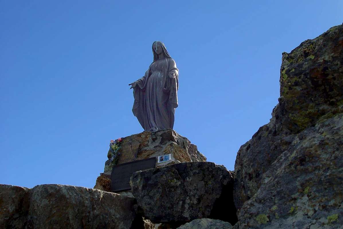
Barbed Stone & three Madonnas?
But how many Madonnas has Barbeston?
Two, but sometimes even three. Two or three? It depends. Close to the "pagan" tripod trigonometric there is the first, the smallest, which almost seems to take shelter in the storms lightning with this human "contrivance"! Just farther to the east rises the Great Black Madonna, placed on a stone altar with a lot of book for the visitors in the drawer iron.
The Old & New Black Madonna of Mount Barbeston, by Osw
And the third?
The third is a Lady who takes the place of the second. It is not given to know if the cold or if the Miracle to become a silver colour. But only occasionally and it is not easy to photograph.
"The Black Madonna turns his back, then the Silver Miracle! La Madonna Nera gira le spalle, poi il Miracolo d'Argento!", by emilius
Ma quante Madonne ha il Barbeston?
Due, ma, a volte, anche tre. Due o tre? Dipende. Vicino al "pagano" tripode trigonometrico c'é la prima, la più piccola, che quasi sembra ripararsi nelle tempeste dai fulmini con questo umano "ordigno"! Appena più in là ad Est si alza la Grande Madonna Nera, posta su di un altare in pietra con tanto di libro per i visitatori nel cassetto in ferro.
"The Blessed Virgin made me Grace: covered everything with a pitiful Snowy Cloak" / "La Santa Vergin m'ha fà 'n'a Grassia: ha tut cupert cun Mant Nevus de Pietà", by Corvus
E la terza?
La terza é una Madonna che prende il posto della seconda. Non é dato a sapere se per il freddo o per un miracolo diventa di color argento. Ma soltanto di tanto in tanto e non é facile fotografarla.
"We went upward from there but there was nothing! / Siam 'ndé sù per là ma gni'era propri gnènt!, by emilius
These two, which you see here, they took me to Barbeston (barbed stone?) with the motivation to look for minerals. Twenty-six years ago. We climbed from Voeulla Praz d'Oursì and from this, after eating, we went to Pian Tsaté or Plan of the Castle (which one?) under the Southeast Slope of Barbeston. From there we climbed. Two spinning like tops, even better, as two moles and digging. Without finding anything. Not a trace of minerals. Maybe if something were seeking gold or petroil. Nothing but minerals. So I got tired of watching this vain search, and went on to climb two beautiful towers in the shape of the pulpit in the little castle of Summit. At least I enjoyed it. They, taken from incurable hallucinations mineralogical, they began to philosophize. Then you are put to sleep. Disappointed. We went down to Valmeriana Hill and the Black Madonna issued a sigh seeing this band of wretches away. So I knew the Barbeston and its two Madonnas ...
"You think you find Brave Warriors, who instead looks Scrap! / Tu pensi d'incontrar Prodi dei Monti Guerrier, invece varda che Rottamaglia!, by Osw
Questi due, che qui vedete, m'han portà al Barbeston (pietra appuntita ed uncinata?) con la motivazione di cercar minerali. Ventisei anni fa. Siam saliti da Voeulla a Praz d'Oursì e da questo, mangiato, siam 'ndati a Pian Tsaté o Pian del Castello (quale?), sott'al Versante Sudest del Barbeston. Di lì siam saliti. Giravan come due trottole, anzi, meglio, come due talpe e scavavan. Senza trovare gnènte. Gnanca 'na traccia, un fil de mineral. Forse se cercavan oro o petrolio qualcosa trovavan. Ma mineral niente. Così mi son stufà d'osservar sta vana ricerca di sti dò màtt e son andà a rampégar su due bei torrioni a forma di pulpito sottal castellett sommital. Almen mi son divertì. Lor, presi da inguaribil allucinazioni mineralogiche, si son messi filosofare. Poi a dormir. Delusi. Siam scesi al Colle di Valmeriana e la Madonna Nera ha emesso un sospiro vedendo allontanar sta banda di sciagurati. Così ho conosciuto il Barbeston e le sue due Madonne ...
" "
"What do you do Grauson Old? / Cosa fai Vecchio Grauson?", by emilius
 |
Ma, forse, revic con il radical re vuole significare dietro quasi una replica, ovvero il monte che rimane dietro ad un altro monte, come Mont Paramont significa monte che ripara un altro monte. Cioé un monte occultato o preceduto da un secondo monte. Ed allora é nel Destino del Ruvi avere sempre davanti a Mezzogiorno il Monte Avic. Lui resterà, purtroppo, per l'Eternità il Monte di Dietro. Sotto al Monte Avic che, anche se per non molti metri, é più alto ed importante di lui. Comunque, anche se veramente poco frequentato, rimane una bella, possente, antica e selvaggia montagna. La si ammira spostandosi ad Occidente in Valle di Aosta, oppure alzandosi sulle balconate a Meridione della Dora Baltea. Non difficile, ma mai di banale salita, alza le sue creste e pareti bruciate e cotte dal sole nonché spazzate dai venti di tramontana e spezzate dai ghiacci invernali al di sopra dei suoi ruvidi valloni, al limite del Parco Naturale del Monte Avic. Per le sue fattezze, se osservate le foto, potrebbe essere tranquillamente nel Gran Canyon. Chi é quel Genio che qui lo trapiantato?
Quel ruvi o revic proviene sicuramente dai minatori che in epoche ormai remote, qui erano di casa e su questi punti di riferimento regolavano la loro triste e dura realtà.
The total number 13 is not there, because in the U.S.A. Thirteen does not bring the Fortuna and we do not subsume invent!
"Come on! Somewhere we get ... / Andiam! In qualche posto arriverem ... ", by emilius
 |
This, excluding Overviews, is the section number thirteen of this work CURT XI°. A number is not well-liked in America. There are no roads, streets and homes with this. So they told me, and so I have seen in a television broadcast. And then how do we to give him a mountain? All they would do their fingers crossed fingers crossed, or, as is done in Italy, equipping with him garlic, like the Vampires, and chili small pepper. Red, of course. As if the Devil comes that comes from Hell ... But we have thought of a trick: a real mountain , and consolidated with name no. But a mountain forgotten, unknown and that only the passion for research brings to light it. A mountain in Summer says almost nothing, but in Winter, when you are fatigued with snowshoes lost in a sea and white with no name, gives you a reference point and a destination in mind then. Maybe comes out from the snow and gives you an open space where stop to eat dry. Still you. Let her also the number thirteen, a number that for us, on that day, it was "fortunato".La We christened with the name of Point Ervillères, named alp below to the North. We have erected a stone cairn and from that day she exists. We had a cold day, but happy. Thing that is not just in the Life. Despite the number 13.
Ah, as usual, I forgot, this tiny mountain is 2799 meters high, but with the stone cairn built by us in reaching Summit, just right, the Nobility of 2,800 meters. It is not a new Orogeny! ...
 |
Questa, Overviews a parte, é la sezione numero tredici di questo lavoro di CURT XI°. Un numero di certo non ben voluto in America. Non ci son strade, vie ed abitazioni con questo. Così m'han detto e così ho visto in una trasmissione televisiva. Ed allor come facciam ad attribuire lui una montagna? Tutti farebbero gli scongiuri incrociando le dita, oppure, come si fa in Italia, attrezzandosi con aglio, come per i Vampiri, e peperoncino. Rosso, logicamente.
 |
Come s'arrivasse il Diavolo proveniente dall'Inferno ... Ma noi abbiam pensato ad un escamotage: una montagna vera, consolidata e con tanto di nome no. Ma una montagna dimenticata, sconosciuta e che sol la passione per la ricerca porta alla luce si. Una montagna che d'Estate non dice quasi nulla, ma che in Inverno, quando sei affaticato con le racchette da neve sperduto in un mare bianco e senza nome, ti regala un punto di riferimento ed una meta precisa allora si. Magari fuoriesce dalle nevi e ti regala uno spiazzo asciutto dove fermarti a mangiare. Ancor si. Diamo a lei pure il numero tredici, un numero che per noi, in quel giorno, é stato fortunato. L'abbiam battezzata col nome di Punta di Ervillères, da quello dell'alpe sottostante a Settentrione. Abbiamo eretto un tumulo in pietra e da quel giorno lei esiste. Noi abbiam avuto una giornata fredda, ma felice. Cosa che non é da poco nella Vita. Nonostante il numero 13.
Ah, come al solito dimenticavo, questa minuscola montagna é alta 2799 metri, ma con il tumulo in pietra da noi costruito in Cima raggiunge, giusto giusto, la Nobiltà dei 2,800 metri. E non si tratta di una nuova Orogenesi! ...
 |
The Black Madonna of Mount Barbeston (= Barbed Stone?)
But how many Madonnas has Barbeston?
Two, but sometimes even three. Two or three? It depends. Close to the "pagan" tripod trigonometric there is the first, the smallest, which almost seems to take shelter in the storms lightning with this human "contrivance"! Just farther to the east rises the Great Black Madonna, placed on a stone altar with a lot of book for the visitors in the drawer iron.
 |  |  |  |  |
And the third?
The third is a Lady who takes the place of the second. It is not given to know if the cold or if the Miracle to become a silver colour. But only occasionally and it is not easy to photograph.
 |
Ma quante Madonne ha il Barbeston?
Due, ma, a volte, anche tre. Due o tre? Dipende. Vicino al "pagano" tripode trigonometrico c'é la prima, la più piccola, che quasi sembra ripararsi nelle tempeste dai fulmini con questo umano "ordigno"! Appena più in là ad Est si alza la Grande Madonna Nera, posta su di un altare in pietra con tanto di libro per i visitatori nel cassetto in ferro.
 |
E la terza?
La terza é una Madonna che prende il posto della seconda. Non é dato a sapere se per il freddo o per un miracolo diventa di color argento. Ma soltanto di tanto in tanto e non é facile fotografarla.
 |
These two, which you see here, they took me to Barbeston (barbed stone?) with the motivation to look for minerals. Twenty-six years ago. We climbed from Voeulla Praz d'Oursì and from this, after eating, we went to Pian Tsaté or Plan of the Castle (which one?) under the Southeast Slope of Barbeston. From there we climbed. Two spinning like tops, even better, as two moles and digging. Without finding anything. Not a trace of minerals. Maybe if something were seeking gold or petroil. Nothing but minerals. So I got tired of watching this vain search, and went on to climb two beautiful towers in the shape of the pulpit in the little castle of Summit. At least I enjoyed it. They, taken from incurable hallucinations mineralogical, they began to philosophize. Then you are put to sleep. Disappointed. We went down to Valmeriana Hill and the Black Madonna issued a sigh seeing this band of wretches away. So I knew the Barbeston and its two Madonnas ...
 |
Questi due, che qui vedete, m'han portà al Barbeston (pietra appuntita ed uncinata?) con la motivazione di cercar minerali. Ventisei anni fa. Siam saliti da Voeulla a Praz d'Oursì e da questo, mangiato, siam 'ndati a Pian Tsaté o Pian del Castello (quale?), sott'al Versante Sudest del Barbeston. Di lì siam saliti. Giravan come due trottole, anzi, meglio, come due talpe e scavavan. Senza trovare gnènte. Gnanca 'na traccia, un fil de mineral. Forse se cercavan oro o petrolio qualcosa trovavan. Ma mineral niente. Così mi son stufà d'osservar sta vana ricerca di sti dò màtt e son andà a rampégar su due bei torrioni a forma di pulpito sottal castellett sommital. Almen mi son divertì. Lor, presi da inguaribil allucinazioni mineralogiche, si son messi filosofare. Poi a dormir. Delusi. Siam scesi al Colle di Valmeriana e la Madonna Nera ha emesso un sospiro vedendo allontanar sta banda di sciagurati. Così ho conosciuto il Barbeston e le sue due Madonne ...
Here there? None is more. They're all dead?
"What do you do Grauson Old? / Cosa fai Vecchio Grauson?", by emilius
 |