West side approach
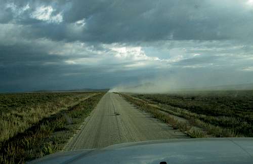
![County road 1084]() Dirt road driving
Dirt road driving
Richard and I had finished up the Hannan range Highpoint and with half a day left of good sunlight, we decided to go down and find our way to the top of Juniper Mountain. In studying Dennis Poulin's information that he posted on peakbagger, it looked like we could do it nicely from the west side. The summitpost page only discussed the east side but the author did mention that it looked like a shorter route was possible from the west side utilizing a jeep road that led up to South Juniper Springs. That turned out to be the way Dennis had gone and so with the hopes of getting a second peak in the same day, off we went in pursuit of Juniper Mountain with his information in our hands.
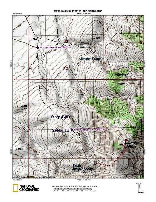
After leaving the trailhead at Hannah Springs, we headed back south and decided to go west on county road 7 (not signed) and aim for hitting county road 2084 and then turning south toward Juniper Mountain. We utilized Benchmark's Nevada mapbook, page 39 to see these roads. I had waypoints for the road that Dennis (see map below) used and by using them, I was able to find our way to the jeep road that is the key for accessing Juniper Mountain from the west side.
![Nice sign]() BLM road sign
BLM road sign![West side approach]() Road heading in
Road heading in
The road leading to the jeep road was OK but the jeep road itself was a bit of a challenge. Fortunately, both of our trucks were able to make our way up to the saddle at 6200 feet that Dennis mentions in his report and I had to use 4WD lo lo to for the last section of the jeep track to make it to that area. The track beyond the saddle was out of the question although a braver driver than myself might pull it off. It was still very hot at 2 p.m. when we arrived so we decided to wait until it cooled a bit before going for the summit.
Our hike
![End of the jeep track]() End of jeep track
End of jeep track
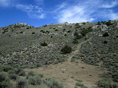
Using the saddle as our trailhead, we walked up the very steep jeep road and after a half mile reached its end at a spot where an old fire ring was located. Beyond the end of the road, an animal trail of sorts headed directly up the mountain side towards the ridgeline and from there (end of the jeep track) it was a straightforward hike up the remaining 600 feet.
It was still pretty warm despite the fact that we waited until after 4 p.m. to start but we took our time and kept hydrated. Hiking in the Nevada desert back country in August really isn't the smartest thing to do but we knew that hiking this mountain via the western approach would work out since it'd be less than 4 miles round trip and only about a thousand feet of elevation gain.
When the slope steepened after leaving the jeep track, the animal paths worked well and were connected enough to make our passage through the brush relatively easy. When we neared the top of the ridge, we headed north and after losing a few feet to a saddle area, we encountered another steep area that led us up to the summit area where we found a cairn, a benchmark and a register bottle. Actually, we found two registers but the second one was more a geocache type and was found next to some rocks about 10 feet below the summit. We enjoyed the views and signed into the register and Richard left the glass bottle containing the register protected by one of his red cans that can be found protecting glass bottle registers on just about any peak he climbs.
![Heading for the summit]() The summit ahead
The summit ahead![Juniper Mountain register]() Register
Register
Heading back downhill, we took the most direct way back to the little saddle thanks to our ability to boot ski some of the scree that made it easy and fast. When we reached the jeep track, we bypassed the road by taking an animal trail that went to the right of it and was a bit more direct. Reaching our vehicles, we arranged them for car camping since we decided to
spend the night on the saddle and wanted to have the advantage of the elevation to help make for a cooler night than if we had gone back down to the valley below where it was sure to be warmer.
![Juniper Mountain Benchmark]() Benchmark
Benchmark![Looking north]() View
View
Richard picked up the weather report for the next day and it wasn't promising for doing Black Peak, just north of us since part of the access to get to the route for that one involves driving on a dry lake bed. If it rained, that lake bed could get wet and we might not like trying to drive on it (think mud). We elected to head to Gerlach the next day and get gas and Richard could hike Pah Rum mountain, a mountain I had already climbed and I could get a nice rest day in before we went after Kumiva peak the day after that.
The sunset was spectacular. Thanks to Dennis Poulin for his shared information on peakbagger, it was appreciated by us as it allowed us to get a 2nd peak on a hot August day. As you may have figured out by now, this trip report also offers enough
information to allow you to find your way up it from the west.
Route Map
Some thoughts about hiking in this area
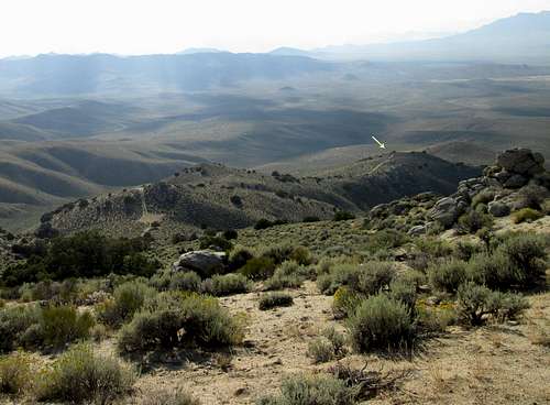
![The saddle]() Overall route view
Overall route view
If you make the long drive out into this area, you should consider getting as many peaks as time will allow. Other peaks to consider in this area:
Black Mountain
Kumiva Peak
See
Northwest route approach
Hannan Range H.P.
Seven Troughs Peak
Trinity Peak
Also, make certain you fill up with gas before you head out and make sure your vehicle is in good shape, has high clearance, 4WD, an extra spare tire and that you have plenty of water and food. Cell coverage is non existant on the roads although I was able to get texts from some of the summits. With Verizon I had summit coverage on:
Kumiva - good coverage
Hannan Range H.P.poor
Seven Troughs - poor
Trinity - good coverage
Juniper - poor
Comments
No comments posted yet.