The page was successfully edited.
|
|
Mountain/Rock |
|---|---|
|
|
37.98961°N / 15.15171°E |
|
|
Download GPX » View Route on Map |
|
|
Hiking, Mountaineering, Trad Climbing, Sport Climbing |
|
|
Spring, Summer, Fall, Winter |
|
|
4396 ft / 1340 m |
|
|
Overview
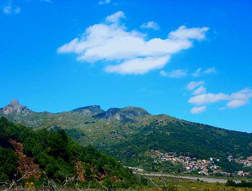
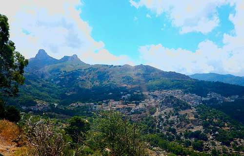
The Rocca Salvatesta is located in the east edge of the Sicily, in the Peloritani mountains; it raises between the two ancient villages of Fondachelli Fantina and Novara di Sicilia from where several paths start to her top. Tales of treasures and an appearing face on her wall contribute to grow her mistery. So good for hiking and climbing cause of her dolomitic structure; it's gifted of one of the best panorama of the world because: 1) it's not joined with other mountains 2)it's the second highest mountain of Peloritani range 3)above all it's so close and just between two seas, the Volcano Etna, the Aeolian Island, the Messina Strait, Milazzo cape and Tindari cape. Because of this sunrise and sunset are wondering; a cross with Jesus is also on its top.Getting There
From NORTH Sicily
If you come from Palermo airport or Messina get the motorway A20 until the exit to the town of Terme Vigliatore on the Tyrrenian sea, then get the road SS 113 until Terme Vigliatore town and then get the road to Rodì-Milici(near a gasoline station) and after you overcame the two hamlets, follow the road running always beside the Patrì river, pass the hamlet of Fantina and then after last 7 Km you arrive at Fondachelli, if you want try the path to the Rocca Salvatesta that startsfrom there.
If you want try the path from Novara di Sicilia when you are in Terme Vigliatore town get the road SS 185, overcome the town of Mazzarra S.Andrea and carry on until Novara di Sicilia.
From Terme Vigliatore to the two towns it will take around 30 minutes, but the road to Novara di Sicilia has more bends than that to Fondachelli.
From SOUTH Sicily
From Catania airport get the motorway A18 until Giardini Naxos just after Taormina and then get the road SS 185 to Francavilla di Sicilia and there to Portella Mandrazzi after that you will meet the crossoroad to the two towns.
From Giardini Naxos to the two towns it will take around 50 minutes.
Route
These are the most classic tracks to the Rocca Salvatesta, two of them because start directly from the closest towns, one because is the shortest.With a good organisation of transports and accomodation you can also combine them also if I advice to go up from Fondachelli and go down to Novara to enjoy at the best their panorama for a great trek. Do not forget to visit also the precipice of Ritagli di Lecca so close to the top of Rocca Salvatesta.But if you want you can also start directly from the sea.
Track from Fondachelli Fantina townThe natural start is the fountain of the Pozzetto in the hamlet of Rubino and it’s a blind start because you don’t see your destination Rocca Salvatesta. It’s the track most challenging because of the gradient of some segments but it’s also so various as in rapid order little woods, caves, the plateau of Pizzo Vento signaling the equinox, Rocche di Durante, shocking view from monte Baratta, megaliths of Valle di Levante and the spectacular precipice of Ritagli di Lecca are all on way, it's a dive in an hidden and mysterious sicilian prehistory! Around 4,6 km.
Basicly the skyline is the path.
Basicly the skyline is the path.
Track from Vernida wood
This track starts from the road SS185 just at half road between Novara and Fondachelli separated from only 12 km by car, it begins from an area with tables and barbecues, there’s not high gradients, unless the last common segment of the calcareous pyramid, it’s the shortest and then particularly suitable to the family with children. Around 3,5 km.
Track from Novara di Sicilia town
The trail from Novara starts from the San Giorgio bridge, the first part goes into a beautiful wood around a lovely stream that feeds a mill in the valley, the second part, after a big turn on the right and many rocks on way is the same of the track from Vernida wood, prehistoric signs are also there. Less high gradient than the track from Fondachelli but longer, around 6.8 Km.
Red Tape
no red tapeWhen to Climb
Always. Every season is a new dress that extols the beauty of the Rocca Salvatesta. You can climb it also when it snows.
Camping
Camping is toleratedExternal Links
Wheater: http://www.ilmeteo.it/meteo/Fondachelli-Fantina
Public Transport: www.aziendasicilianatrasporti.... ; check the page "Linee e orari" for places and time of the bus
Staying: https://www.facebook.com/dormireafondachelli/
http://www.villasicily.it/galleryfantina
http://www.agricolacatalano.it/nuovi_sapori.php
http://www.villasinsicily.net/en/
http://www.casavacanzanucaria.it/