La montagna chiama i suoi figli, ed essi rispondono fedelmente al suo appello…
Osvaldo Cardellina, Diario alpinistico, 1964-65
Page texts: @ OsvaldoCardellina"Osva", passed away on May 2, 2022. Page owners: Christian Cardellina e Osvaldo Cardellina. Any updates from September 12, 2022: Antonio Giani, page administrator, friend and climbing companion.
Testi della pagina: @ OsvaldoCardellina "Osva", scomparso il 2 maggio 2022. Proprietari pagina:Christian Cardellina e Osvaldo Cardellina. Eventuali aggiornamenti dal 12 settembre 2022: Antonio Giani, amministratore della pagina, amico e compagno di salite.
Overview
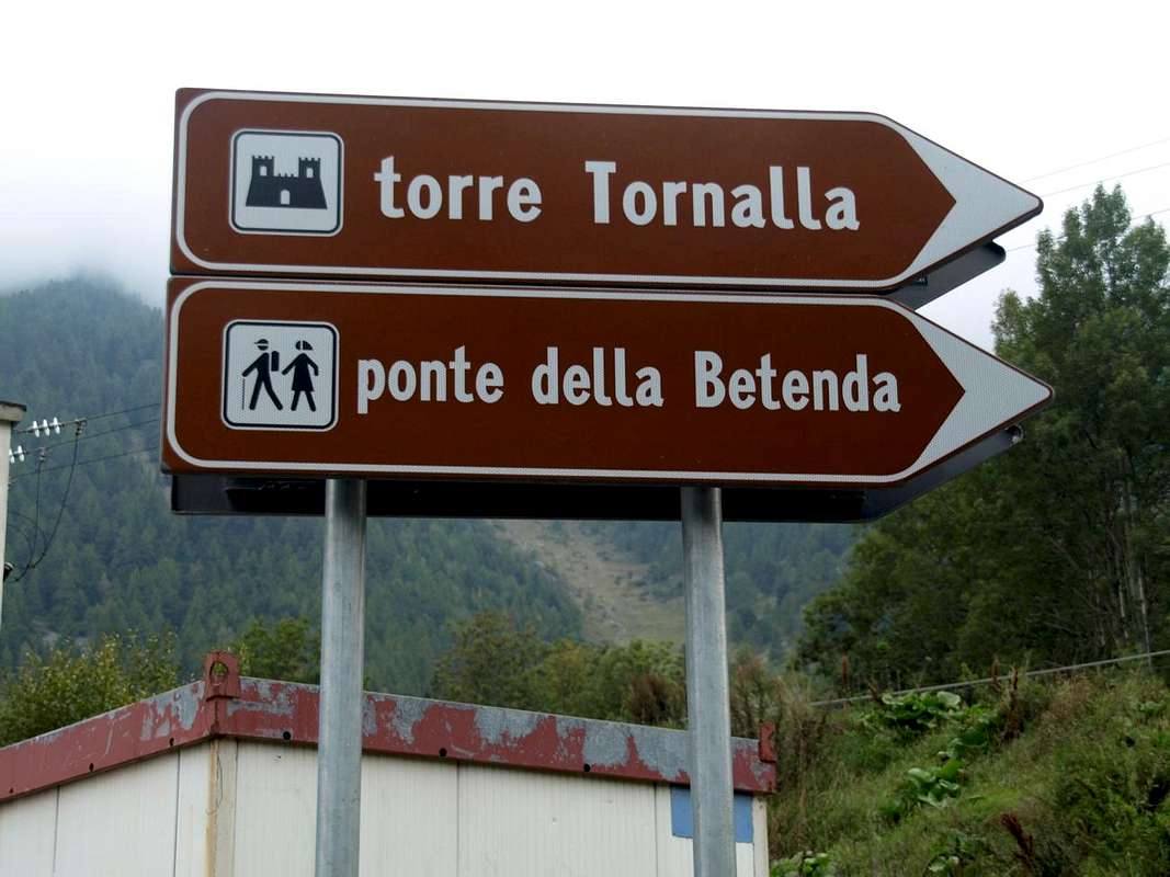
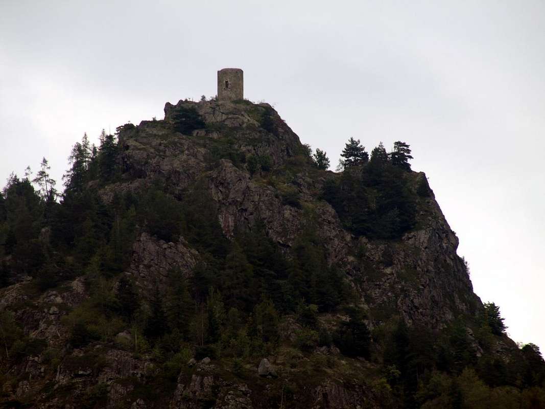
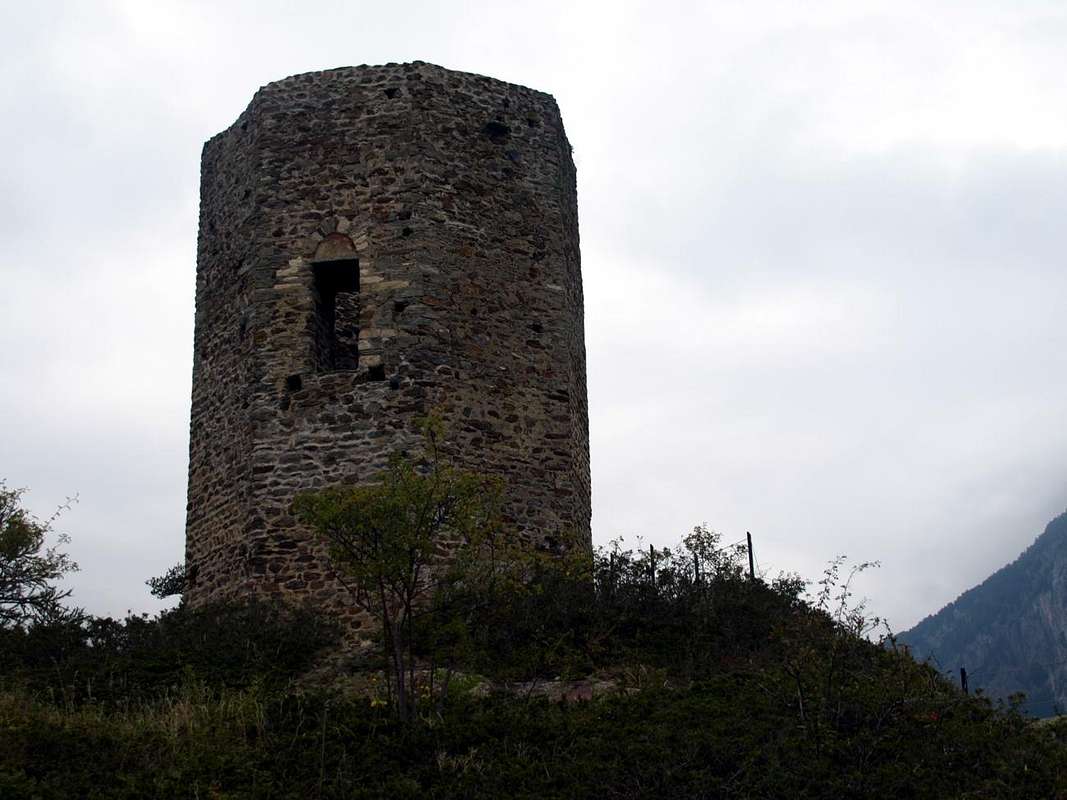
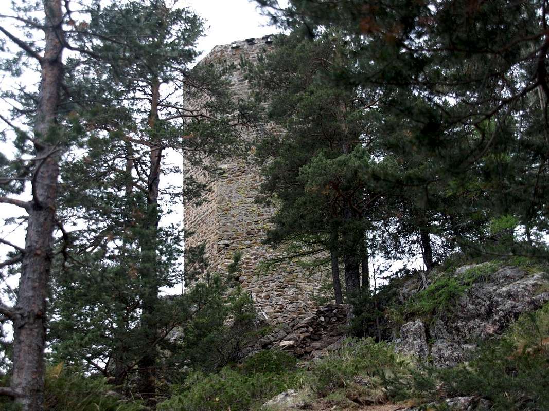
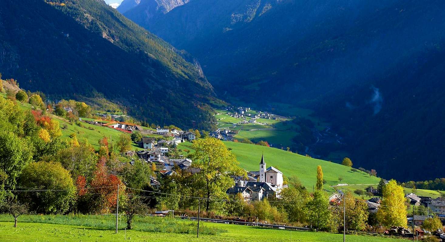
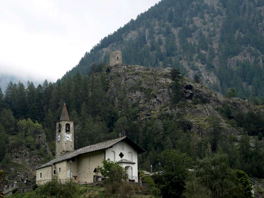
A small trip to the Tour de la Tornalla of XII° Century, this the small excursion or, better, his is hike a trip-walk to one of the older guard towers of Aosta Valley. If desired, herself can be matched to the underlying Bridge Betenda. Set on a rocky promontory above the Crétaz (1.316m), Voisinal and Grenier Fractions (Oyace), closes the course of the valley "controlling" the continuation of the same to the next Commonn of Bionaz with its large Dam of "Moulin des Places" (1.622m), but better known as "Place Moulin", as they called the workers who worked there in the building of the fifties. A defense that no longer makes sense to exist, because, today, the road "runs" quiet towards the border with the Grandes Murailles Valtournanche and not Valtournenche (go check the old marble plaques on the front page of the Municipal Square). It is not this the place where you want to tell the story of the same, which will perform in a specific article separately. Here you simply want to specify a path, falling to the Betenda Bridge at the mouth of the two Combe Vessona and Verdona; it becomes even more beautiful and really impressive. It prompted some attention ... Then, the most talented and trained can, crossed the Buthier de Valpelline, continue towards Mount Faroma (3.073m) or to the St. Barthélemy Hill (2.646m) ...
Risulta siccome piccola gita alla Tour de la Tornalla del XII° Secolo; questa la piccola escursione o, meglio, gita-passeggiata ad una delle più vecchie torri di guardia dell'intera Valle d'Aosta. Che proprio volendo, la si può abbinare con quella al sottostante Ponte della Betenda sopra il Torrente Buthier de Valpelline.Collocata sopra un promontorio roccioso sopra le Frazioni di Crétaz (1.316 m), Voisinal e Grenier (Oyace), chiude il corso della valle "controllando" il prosieguo della medesima verso il successivo Comune di Bionaz con la sua grande Diga di "Places des Moulin", ma meglio conosciuta come "Place Moulin"(1.622m), come la chiamavano gli operai che lì lavoravano nella costruzione degli Anni Cinquanta. Un presidio che non ha più senso d'esistere, perché, oggigiorno, la strada "corre" tranquilla verso le Grandes Murailles al confine con la Valtournanche e non Valtournenche (andate a controllare le vecchie lapidi in marmo sul frontespizio della Piazza Comunale). Non é questo il posto dove si vuole raccontare la storia della medesima, cosa che effettueremo in uno specifico articolo a parte. Qui si vuole semplicemente indicare un percorso che, scendendo al Ponte della Betenda all'imbocco delle due Combe di Vessona e Verdona, diventa ancora più bello nonché veramente suggestivo.Far più attenzione perché il percorso é facile, ma il sentiero esposto ... Poi, i più bravi ed allenati possono, attraversato il Buthier de Valpelline, proseguire verso il Monte Faroma (3.073 m) oppure al Col di St. Barthélemy (2.646 m)...
Getting There from Aosta toward Oyace
BY CAR:
From TORINO, MILANO, etc: Motorway A5. Exit at IVREA or Quincinetto (PIEDMONT).
From IVREA Town: before in West to Aosta, after in Northeast towards Gignod, Valpelline, Oyace and Bionaz Municipalities. From Courmayeur Resort: before in East to Aosta, after in Northwest to Gignod and in Northeast towards Valpelline, Oyace and Bionaz Municipalities.
From Valpelline Municipality towards Oyace Commune in Valpelline Valley From Valpelline(580m), with Regional, to Oyace Common (1.316-1.377m); this to North and South Vallons (Brison, Crête Sèche, Vertsan, Tsa Comba, Grand Chamin Comba, Comba des Lacs and d'Orein up to the entrance into the vallon between Gran Vanna-Braoulé-Bouquetins and Petite/Grande Murailles, below Valpelline Pass.
From FRANCE: through the Mont Blanc Tunnel to Entrèves-crossroads to Vény/Ferret Valleys - Mountain Guides of Courmayeur - La Saxe Rock Gym - Courmayeur. By Little Saint Bernard Pass, closed since November until half May to La Thuile Valley - Pré Saint Didier - Courmayeur. It is not necessary to take Motorway A5: you can drive on SS.26, in the direction of AOSTA - IVREA - TURIN.
BY PLANE:
Aeroporto "Corrado Gex" Saint Christophe (Aosta).
Route Description towards Tornalla's Tower
A small Trip to the Tour de la Tornalla the XII° Century
From small Villages Voisinal, Grenier, and Crétaz Serignan you can reach with a short walk this Tower "holed up" on the above-wooded rocky promontory. A first trail n° 3 starts by Grenier-Vernoce Fraction (1.257m), addressed first to the East, then Northeast and across the Bois "Les Cretes" reaches the Tornalla's Tower on its West side. The second, also well marked with signs in brown, always starts as n° 3 by the Village of Serignan-Chez les Bredy (1.385m), soon after the Church of St. Michel and Crétaz Fraction, and begins the ascent to the East for then fall back strongly in the South. At the junction with the trail, down towards the underlying Betenda Bridge above the Buthier de Valpelline, turn sharply to the right (West) and drive past some small basins reaching a fence in a protective timber. A final more steep section and exposed to the South, by means of some steps on the rocky plates, leads to the Tour de la Tornalla, which is reached on its Eastern side (T/F; 0h'30). Currently at the start and at the "Bouc Plan" is under construction a direct variant that runs along the Northern side of the interior of the forest of "Plan Bouc". In any case, be very careful when children are present, since the grassy-rocky promontory summit, with some wooden benches on the side West, is very scenic but also very exposed on all sides, especially to the South and West. If you want to get off at the Ponte Betenda(0h'35) you must continue from the junction with the tower down a narrow and very steep path which, through the forest, down in North-northeast, reaching the spectacular "Gouffres de la Betendaz" towering over the course of Buthier de Valpelline (Here you can also arrive by the nearby Close Fraction (1.457m) via the path Alta Via n° 1 or from that of Place (1.495m) with a not numbered path that later joins the trail n° 16, from the locality of Plan Bouc (0h'30/0h'45).
Una piccola Gita alla Tour de la Tornalla del XII° Secolo
Da Voisinal, Grenier, Crétaz e Serignan si può raggiungere con breve camminata questa Tour "asserragliata" sul soprastante promontorio boschivo-roccioso. Un primo sentiero n° 3 parte da Grenier-Vernoce (1.257 m), rivolto dapprima ad Est e poi Nordest ed attraverso il Bois "les Cretes" raggiunge la Tour sul suo lato Occidentale. Il secondo, anche esso ben segnalato con cartelli in marron, parte sempre come n° 3 dal Villaggio di Serignan-Chez les Bredy (1.385 m), subito dopo la Chiesa di St. Michel e Crétaz, e inizia la salita verso Est per poi ripiegare decisamente a Mezzogiorno. Al bivio con il sentiero per il Ponte della Betenda svoltare decisamente a destra (Ovest) ed oltrepassate alcune piccole conche raggiungere una staccionata in legno protettiva. Un ultimo tratto più ripido ed esposto a Sud conduce, per mezzo di alcuni gradinamenti sulle placche rocciose, alla Tour de la Tornalla, che si raggiunge sul suo lato Orientale (T/F; 0h'30). Attualmente nella parte iniziale e presso il "Plan Bouc" é in fase di costruzione una variante diretta percorrente il lato Settentrionale all'interno della Foresta del "Plan Bouc". In ogni caso prestare molta attenzione in presenza di bambini, poiché il promontorio erboso-roccioso sommitale, con alcune panche in legno sul fianco Ovest, risulta molto panoramico ma anche alquanto esposto su ogni lato, soprattutto a Sud e ad Occidente. Invece volendo scendere al Ponte della Betenda si deve continuare dal bivio con la torre scendendo uno stretto e molto ripido sentierino che, attraverso la foresta, scende in direzione Nord-nordest raggiungendo le spettacolari "Gouffres de la Betendaz" che sovrastano il corso del Buthier de Valpelline (Qui s' arriva anche dalle Frazioni di Close (1.457 m) tramite il sentiero Alta Via n° 1 e di Place (1.495 m) con un sentierino non numerato che in seguito confluisce nel sentiero n° 16, proveniente da Plan Bouc (0h'30/0h'45).
Essential Gear for Tourists & Hikers
Difficulty This route can be considered T/E or Tourist and Easy also EE (Expert Hikers) for and to the Betenda's Bridge.
L'itinerario è classificato T/E ovvero Turistico e Facile oppure EE (Escursionisi Esperti) per il Ponte della Betenda.
Oyace nearby the Village of Serignan-Chez les Bredy the trail towards Tour de la Tornalla or Oyace-Crétaz to Tornalla's Tower or Southeast
Equipment Hiking gear or in winter with snowshoes.
Da Escursionismo oppure in inverno tramite Racchette da neve.


 2012 Hits
 78.27% Score
 9 Votes