
-
 1160 Hits
-
 77.48% Score
-
 8 Votes
|
|
Route |
|---|---|
|
|
40.31154°N / 4.89578°W |
|
|
Download GPX » View Route on Map |
|
|
Hiking |
|
|
Spring, Summer, Fall |
|
|
Half a day |
|
|
Hike |
|
|
Overview
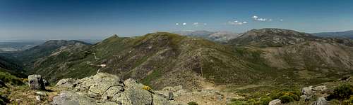
 Risco de Miravalles Risco de Miravalles |
From Seranillos to the north of Cerro de Cabezo there are two more or less reasonable hiking routes towards the various summits of the mountain, which can neatly be combined into a loop trail, which traverses most of the east-to-west summit ridge. The easier and more straightforward of the two is the hike to Puerto de Lagarejo in the west, where the ridge traverse starts directly in the saddle.
While at first a hike along dirt roads until you reach Puerto de Lagarejo, the hike turns into a mix of narrow path, bushwhack through a veritable sea of Spanish Broom, steep scrambles towards the summits and a somewhat exposed rock-hopping ridge traverse between Cabezo de Gavilanes and Cabezo de Mijares. Elevation gain is some 1100m and the distance covered to reach both main summits amounts to some 8,5km.
In winter snowshoeing is possible, tour skiing is difficult because of the omnipresent bushes of Spanish Broom.
Getting There
 Looking towards Macizo Central from Rico de Miravalles
The trailhead at the village Seranillos can be reached as follows:
- From Avila take AV-900 to Burgohondo.
- Switch to AV-913 west until you reach Seranillos.
Route Description
 Huge fields of Spanish Broom cover Sierra del Cabezo so that routefinding can become difficult
- General:
- Start altitude: 1200m
- Summit altitude: 2191m
- Prevailing exposure: N
- Type: Hike, Scramble and Bushwhack
- Protection: None
- Start altitude: 1200m
- Effort: 2 - Elevation gain: 1100m
- Power: 2 - Strenuous
- Psyche: 2 - Easy, a bit more serious right up to Cabezo de Gavillanes and on the traverse to Cabezo de Mijares
- Difficulty: 1 - Easy
- Orientation: 2 - Some tricky patches between Risco de Miravalles and Cabezo de Gavillanes
Head out of the village Serranillos along AV-900 in direction of Puerto de Seranillos. At the height of the bar El Puerto head down left across the creek, which comes down from Puerto de Lagarejo. Turn left and follow the road (first asphalt, later dirt) accompanying the creek, which runs up Garganta del Puerto de Pedro Bernado. It runs through patches of gardens and fields almost up to the shallow saddle itself.
In Puerto de Lagarejo turn left, heading up towards the rocks on the shoulder of Risco de Miravalles. There are stone cairns along the path but in several sections you'll have to struggle through the ever denser Spanish Broom. As you close in onto the shoulder, which is Risco de Miravalles the slope gets very steep for a short section.
 Cabezo de Gavilanes Cabezo de Gavilanes |  Gavilanes summit block Gavilanes summit block |  Gavilanes summit view Gavilanes summit view |
Pass the rock heap, which is the summit of the risco, after which you enter a flat bowl stretching across the distance towards Cabezo de Gavilanes. Again, Spanish Broom obstructs the path and orientation in this section can be a bit tricky, even though the next destination is clearly visible. Head for the west ridge, where you will regain the path (again marked by cairns). It heads up the ridge, ever getting steeper. Right before you reach the summit block it crosses over to the north face briefly, only to retreat back to the south side and to negotiate the left side of a broad but steep couloir. Like a winding staircase the ridge turns right in ever decreasing radius until you reach the top of Risco de Gavilanes.
 Cabezo de Gavilanes Cabezo de Gavilanes |  Cabezo de Mijares Cabezo de Mijares |  Cabezo de Mijares Cabezo de Mijares |
Now the most impressive of the climb starts. From the summit turn east and follow the rocky slabs, which lead directly towards the next summit, Cabezo de Mijares. Depending on where you go (north or south side) you can encounter different levels of difficulty (mainly UIAA I) and exposure (more severe on the north side). There are some minor false summits which require the use of hands but finally you'll reach the saddle between the summits.
Now the character of the route switches again: a broad backed ridge leads to Cabezo de Mijares, densely covered in a sea of Spanish Broom. Orientation might be easy but the going is not - you'll have to bushwhack your way through all these bushes to finally reach the surveying pillar on top.