
|
|
Mountain/Rock |
|---|---|
|
|
46.94163°N / 121.90939°W |
|
|
4880 ft / 1487 m |
|
|
Overview

Virginia located on at ridge located near the northwest border of Mount Rainier is forested high point on the ridge. Virginia Peak is on the same ridge that connects Martin Peak all of the way to Tolmie Peak. The summit itself is much better done with snow that without. In summer this peak is just a short bushwhack walk up to the forested summit. The summit does not have any impressive views because of the thick forest that lies on the peak. In fact it is the least scenic of all the summits on this ridge. That being both nearby Berry and Martin have decent views of the surrounding area.

It is recommended that Virginia Peak and the connecting ridge is literally done just after Mowich Lake Road up to the Paul Pete Trail has been plowed. Usually the snow conditions up on the mountain will be just right for a three summit traverse. Berry Peak is doable in summer but you must expect to do thick bushwhacking in thick lush forest.

To get to Virginia Peak you want to park at the Paul Peak Trailhead just beyond the the Mount Rainier National Park. Once at the the trailhead walk back down the to the park boundary to the decommissioned Boundary Trail. This trail is decent condition and becomes obvious once you go 30 yards past the road. Continue all the way on the trail up to the top of the ridge where you will turn right and head east, over to Virginia Peak. For some better views and more of a challenge continue to head east until you reach Berry Peak. There you will find your first good view of Mount Rainier.
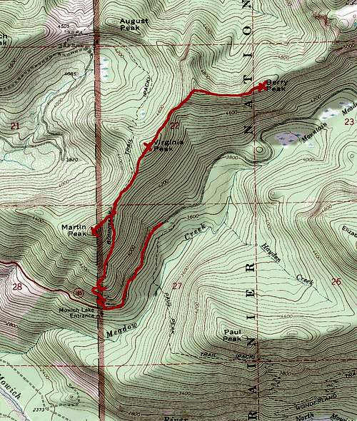
It should be noted to not try to bushwhack from this summit to the Mowich Lake Road. There is a good chance you will cliff out here and the forest below are way too thick for pleasant travel. Follow the ridge back the way you came. Though it may look like more of a distance, it is a much more pleasant and safer alternative.
Getting There
VIA 410 in Buckley: Take Route 165 South. It will soon intersect with Route 162. Continue on Route 165 south through the towns of Wilkeson and Carbonado. You then go over an older bridge ove the Carbon River. This bridge is beginning to look unsteady and would not be a good place to be during an earthquake. Roughly a half mile over the bridge you will run into an intersection with one road veering right and head up Mowich Lake Road. You want to head up 11 miles up past the park boundary and the Paul trailhead will be on your right.Red Tape
Mount Rainier National Park Pass is required at the trailhead. It is $15 for the day and $30 for the year. From my experience though during the offseason, I did not need a Park Pass to park at the Paul Peak Trailhead.Camping
Backcountry Permit Required for Camping while in Mount Rainier National Park. For more information please click hereIt should be noted that the Boundary Trail does spend some time outside of Mount Rainier National Park and in that general area you do not need a permit to camp there.