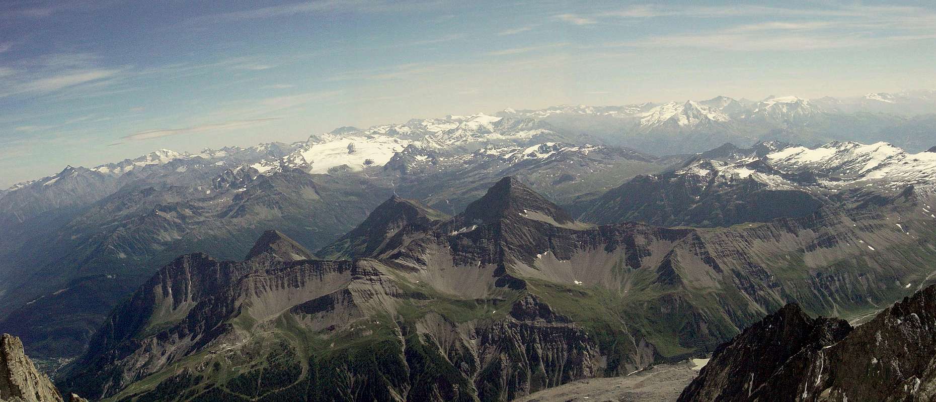
from Pré Saint Didier Municipality, in the Central Valley of the River Dora Baltea, to its Southern end of the Big Summit with high
, as many hills and glaciers, but mostly unspoiled Nature, who will return even more so after. Is a place
that for Mountaineering, there are a great plant; is a place for lovers of real mountain, one that does not have stupid Indian file for ascents, except for the Testa del Rutor. Its most important peaks are on his Eastern side the Testa (Head) of Rutor and other peaks of height between
(Château Blanc, Doravidi, Flambeau) to Planaval Pass preceding Subgroup Mont Paramont
, above Morgex Common. While in the West we have the chain that the Rutor unfolds, after Becca du Lac
, at the height of the eponymous walloon that borders the Tarentaise in France. More to the North of this, a series of parallel valleys (Tormotta, Breuil, Chavannes, Orgères, Bellefaçe, Youlaz, Plan Praz) down parallel forming a hemi circle from Southwest to Northeast reaching Mont Crammont
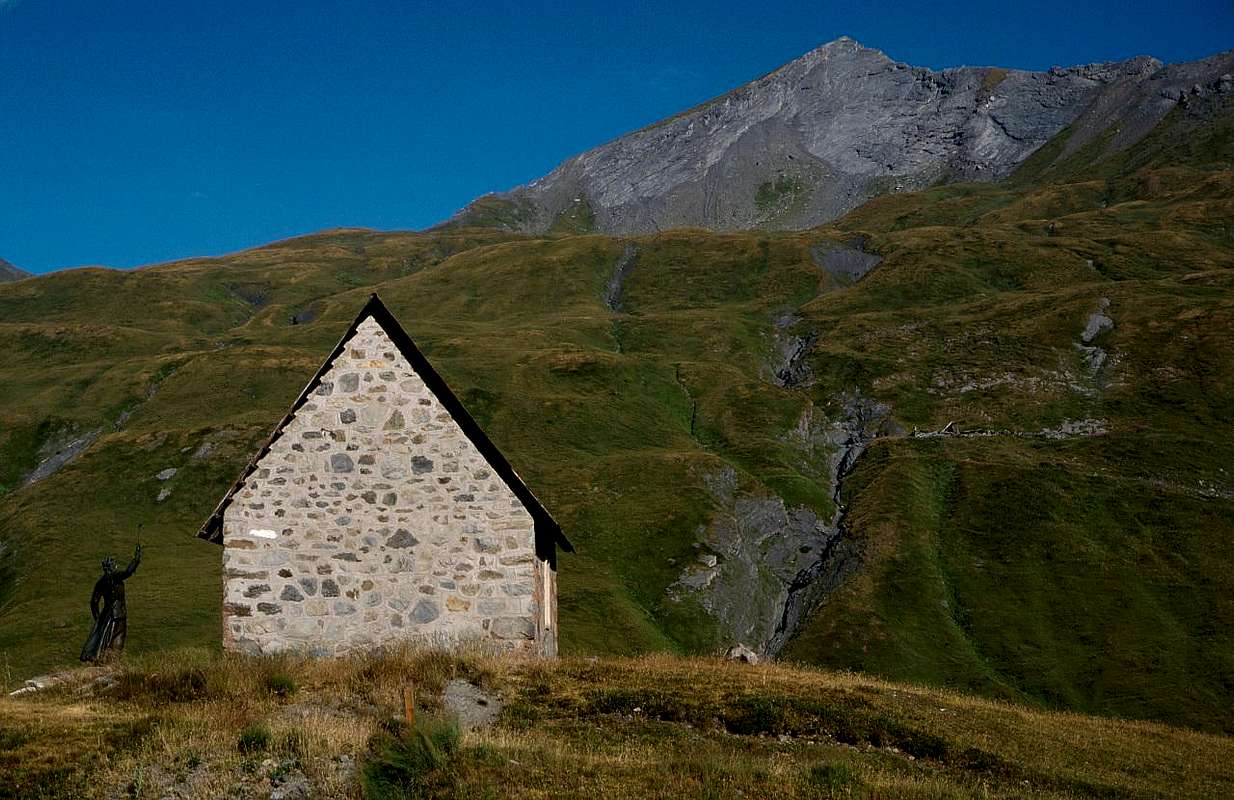
above Pré Saint Didier Common and now at the entrance of the valley. A valley that extends like a great tree from North to South reaching the Hamlet of La Joux
at the foot of the three beautiful waterfalls underlying the great Glaciers of Rutor, below Deffeyes Refuge
; then Westwards to Little Saint Bernard, reaching the same before the Villages la Rosière
into the Tarentaise Region at the beginning of Val d'Isère, by about 28 Km Little St. Bernard. Its input port can be considered the
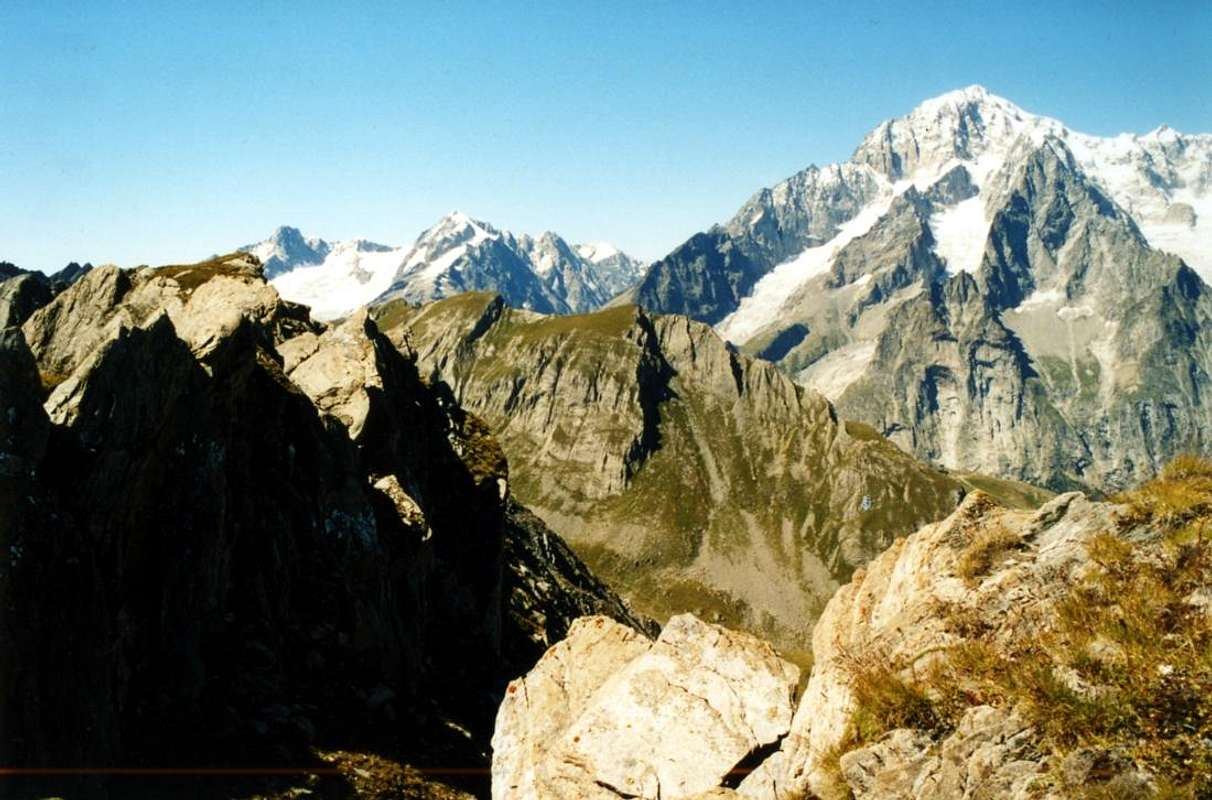
above Pré St. Didier, but its emblem is the
is identified almost on all sides. Both rising from Morgex Municipality, through the overhanging San Carlo Hill, or by Pré St. Didier Common, both going up to Little St Bernard Pass on the border with
La Valle di La Thuile é una delle valli tra le più importanti della Valle d'Aosta. Adiacente alla Valdisère in Francia e confinante ad Est colla parallela di Valgrisenche, si allunga per oltre 12 Km dal Comune di Pré Saint Didier, presso la Valle Centrale del Fiume Dora Baltea, fino alla sua estremità Meridionale con l'abbastanza alta Testa del Tutor (3486 m). Presenta una cinquantina di Cime più o meno importanti, altrettanti colli e numerosi ghiacciai, ma soprattutto Natura incontaminata. Risulta località "In" più per lo Sci che per l'Alpinismo, esistendo un'eccezionale impiantistica; é posto per gli amatori della vera montagna, quella che non presenta stupide file indiane per le ascensioni, tranne che per il Rutor. Le sue cime più importanti sul suo lato Orientale sono la Testa del Rutor ed altre cime d'altezza tra i 3200 ed i 3250 metri (Château Blanc, Doravidi, Flambeau) fino al Passo di Planaval precedente il Sottogruppo del Mont Paramont (3300 m) e del Mont Colmet (3024m) fino alla Testa d'Arpy (2022m), al di sopra di Morgex. Mentre ad Occidente abbiamo la Catena che dal Rutor si dispiega, dopo la Becca du Lac (3405m), verso la Punta Loydon (3147 m) e la Grande Assaly (3172/4 m); qui con un "giro ad arco" raggiunge i tre Monts Fréduaz (2933 m), il Mont Valaisan (2891 m) ed il Passo del Piccolo (2188 m), al colmo dell'omonimo vallone confinante con la Tarentaise in Francia. Più a Nord di questo, una serie di valloni paralleli (Tormotta, Breuil, Chavannes, Orgères, Bellefaçe, Youlaz, Plan Praz) scendono paralleli formando un semicerchio da Sudovest verso Nordest che arriva al Mont Crammont (2732m), sopra Pré Saint Didier ed ormai all'imbocco. Una valle che s'allarga come grand'albero da Settentrione verso Meridione raggiungendo La Joux (1646 m), ai piedi delle tre belle cascate sottostanti i Ghiacciai del Rutor ed al Rifugio Deffeyes (2500 m); indi ad Ovest verso il Col du Petit Saint Bernard, raggiungendolo prima della discesa verso i Villaggi di la Rosière (1808 m) e Séez (984 m), all'interno della Regione della Tarentaise ed all'inizio della Val d'Isère, dopo all'incirca 28 Km dal valico. La sua porta di ingresso può essere considerata il Mont Crammont (2737 m), sopra Pré St. Didier, ma il suo emblema consiste nella Grande Assaly (3174 m) ai piedi dei grandi Ghiacciai del Rutor, mentre il Monte Bianco (4810m) si individua pressocché da ogni parte. Sia salendo da Morgex, tramite il Col San Carlo, o da Pré St. Didier, sia andando verso il Piccolo San Bernardo al confine con la Tarentaise. Quasi gli abitanti di La Thuile fosser anche figli di Sua Maestà ...
So he has seen, over the centuries, go to the Little St. Bernard Salassians, Romans, Armed French, Spanish, Russian, Austrian, even (?) Napoleon Bonaparte. This is the "La Thuile" ... or the valley of the "tile". Ancient Roman Ariolica, was famous in a past not too far away, as well as for transit through the Col Piccolo San Bernardo, for its coal mines used in Aosta in Steel Mill National Cogne SpA, succeeded in 1927 to Ansaldo of Genoa; also was known for the extraction of stone slabs used for the construction of roofs, whence the name Thuile from French tuile. Regarding the Vallon of
"Piccolo", to signal that it led the
Roman Road to Gaul, who crossed the bridge
Pont Serrand, the oldest in the entire valley. On this street are transited Armies every nation by Hannibal, Julius Caesar, Vitellius with the XIV° Legion, Septimius Severus Caligula, who, fascinated, here wanted to build a city; but never by Napoleon that held in high regard this step. Transits more
"sensational" are those of the Burgundian King Gundikar with more than 80.000 men, San Pietro II° Tarentaise Bishop, Umberto Biancamano, Godfrey of Buglione, Duke of Savoy Carlo Emanuele I°, Prince Tommaso Savoy's, the Army of Henry IV° and the Generals Huguette, Mauroy, Moreau, Duhesmes and Suvarow, at the head of armies that ranged from 5.000 to 15.000 troops, even with 5.000 horses.
True Stories and some Hystoric Legend1)- Legend tells (but has been taken from an ancient document) of "Ravine Pont Serrand". It looks like that a Knight of the Aosta Valley, returning from the Sardinia's King, has preferred groped to jump the Ravine with his horse rather than remain a prisoner of the French, smashing itself together the horse into the terrible Abyss from whence the name of
"Saut du Cheval". The bridge, built in ancient upstream of a Roman bridge which has remained only a trace, was blown up by Piedmontese troops in retreat after the
Traverset Battle 1794. It measured 16.70 metres of rope and 4.20 metres length, while the current was rebuilt in 1874 after the primary
Italy Unification.
2)- History speaks instead of
"Camp Prince Tommaso" that with the
Trenches to Petosan, under San Carlo Hill, resisted the French in a war that lasted over a Century.
3)- A plaque on the outside wall of
St. Nichoals Church recalls the brave Commander of the Grenadiers
Count Jerome Ricci of Andorno died in La Thuile after deadly wound received at the Battle of Traverset at the
Piccolo San Bernardo with its withdrawal of Troops from Piedmont of
His Majesty the King of the two Sardinian States.
4)- The Roman Consular Route it is located halfway between somewhere Legend and the real History, but this last takes its revenge still showing his remains which allowed at
Legions to cross the Alps on the
"Via delle Gallie or Gaul Route". We can still follow many of the same parts, concomitant with the
Path No. 9, from Pont Serrand to Lake Verney and Little St Bernard Pass, where we find the
"Mansio Romana and Columns de Joux or Jupiter", but not to do hurt anyone, even the famous
Celtic Cromlech.
5)- The placename La Thuile looks up since year 1040 as Thuilia, Tuelia, The Tueilli, Tuilla, Tullia and La Tuile. It consists of the French voice Tuile, or tile, or perhaps even from the Latin cognomen Tullius. In fact the toponym of "La Thuile" was and is also present today in French and Swiss territory, in neighboring regions at Aosta Valley.
6)- From the toponym of Rutor or Ruitor is "given birth" to its Waterfalls or "Rutorines": the wide Basin of Rutor Glacier to relax from its Summit and the nearby Becca du Lac to its base, including between Mount Paramont East and the Great Assaly West. Immediately below is a series of lakes born with the gradual withdrawal of the same. From that of the same name, about 350 metres long, at the Lac des Glaçons, with its spectacular icebergs, and others that together make up for shape the basin perhaps more dangerous probably of the entire Alpine range. From these and to the underlying village of La Joux, before La Thuile, go down the Torrent du Ruitor that in its path exposes three beautiful waterfalls which, together, form a jump in waters more than 260 metres. Starting from the bottom, the first,
high fifty metres is easily accessible by
1h'00/1h'15 with a short deviation on the right from the base trail; followed by a second, less impressive, while the third is reached in
around 2h'15/2h'30. This, besides being the most important and with magnificent view towards the Aiguille de Trélatête-Petit Mont Blanc and from this to the Giant's Tooth or
"Dente", Arête de Rochefort and Grandes Jorasses then passing over the Glaciers de La Lex Blanche, Petit Mont Blanc and superior Brenva, appears as the most dangerous with a substantial air displacement.
7)- Among the many Floods that took place in the Valley of Aosta between 1519 and 2008 it is to be recorded as harmful particularly those related to the glacial Basin of the Rutor, with catastrophes that occurred in the years 1595, 1640, 1646, 1680 and 1751 due to sudden flooding. Among these famous one that saw the collapse of Rutor Lake with great flood, such as to destroy, claiming countless victims among the local population, almost all the bridges until the Ivrea Town in Canavese (Piedmont).
8)- The German Scholar Tubingen charges because to the insufficient storage and restraint capacity of snowmelt from the three glaciers
"des Glaçons", of the Rutor and du Glacier. The warm, porous rocks of the nearby Grande Assaly
(3172/4m) caused the winds so hot as to produce a rise in temperatures up to 48 ° in the sun and the 35 million cubic metres of water in 1680 reached
70 metres in height almost touching the
Chapel Sainte Margherite in the vicinity of the current
Refuge Albert Deffeyes (2500m).
9)- The Anthracitemines were allowed to live for a long time in La Thuile constituting a fundamental economic support as an alternative to Agriculture and Sheep-farming. Ancient documents testify to the presence since 1500 in La Thuile of coal mines but the first artisanal mining exploitation date back only to the early nineteenth century. In the late twenties, La Thuile became a mining town with hundreds of miners and it reach the top after the Second World War, only to suffer a decline that led to the closure of the mines in 1966, followed often by transferring them. In a wide area stretching from Morgex towards La Thuile, to the Col of the Cross, they showed up in several mining concessions, remained independent from each other until the Twenties of the Twentieth Century. In Morgex existed enrichment plants or plants ore beneficiation and mineral coal from there down towards Aosta. The major development occurred when other plants were built and an entire mining village. Above La Thuile inside of the mountain it a transportation network is created that connected different growing areas. From the old mine of Preilet the wagons came from the gallery to get into that of Villaret
(1490m). From the mountain they came to a point of connection with the mines of the opposite side above the Bouic Fraction
(1524m). A winch allowed to link the carriages of the lower floors with the longest tunnel started from the Hill of the Cross
(2381m) to descend to the Plan of Arpy
(1743m) with subsequent transfer with cable car to Morgex. To reach the mining routes above the Buic we must address through the asphalt road from La Thuile towards the Colle San Carlo
(1971m), to the limit with adjacent Basin Arpy.
10)- The Argentiferousgalenamines of Les Suches. Not even the
"most noble" site of silver mines in Bocambre until 1774 (possibly the same strand of the nearby Mont Chétif in Courmayeur?) prevented the transformation of La Thuile in a great ski Resort, which connects with La Rosière in France, consisting together with the tourism activities in the current economic development of this zone. The story of the same is similar to that of coal, but we wanted to do to You a journey through time and space, starting from Salassi to get to the Romans and by the latter, through dozens of Centuries with struggles and
"fratricidal" fights, get to the present day. That they are certainly better than those of a sad past, which has seen passing Barbarians and Armies, more or less holy Popes Bishops, sacred Emperors, Kings vagabonds or Re.
On foot or on horseback.
Putting in Oblivion Traverset Battle 1793, fires and devastation '94 to St. Nicholas Church, even Napoleon Bonaparte who here perhaps it is never transited ...
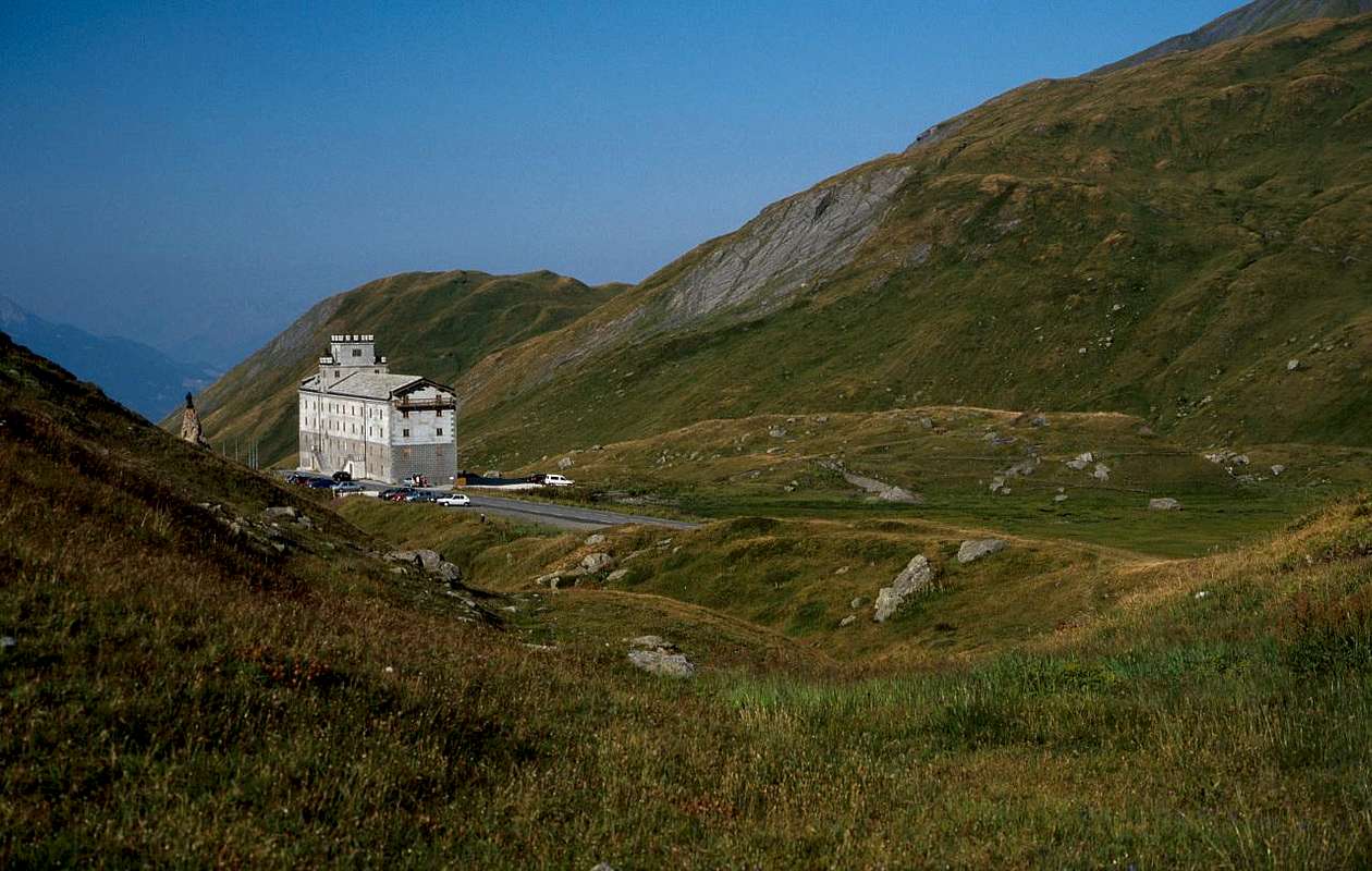
Little St. Bernard Pass with the ancient Hospice, by om
Questa Valle, ha visto, nei secoli, passar dal Piccolo, dai Salassi ai Romani, Armate Francesi, Russe, Austriache Spagnole e forse Napoleone, il Grande Corso.
Si tratta della "Valthuile" ... ovvero la valle della "tegola". L'antica Ariolica romana, era famosa in un passato neppur troppo remoto, oltre che per i transiti dal Colle del Piccolo San Bernardo, per le sue miniere di carbone utilizzato in Aosta nell'Acciaieria Nazionale Cogne S.p.A, succeduta nel 1927 all'Ansaldo di Genova; inoltre rinomata per l'estrazione delle lose usate per la costruzione dei tetti, donde il nome Thuile dal francese tuile. Per quanto concerne il Vallone del Piccolo, da segnalare che ad esso conduceva la
Strada Romana per le Gallie, oltrepassante il ponte di
Pont Serrand, il più antico dell'intera valle. Su questa via sono transitate Armate d'ogni Nazione da Annibale a Giulio Cesare, Vitellio con la XIV° Legione, Settimo Severo e Caligola, che, affascinato, qui voleva edificarvi una città; ma mai da Napoleone che però teneva in gran considerazione il colle. I transiti più
"clamorosi" son quelli del Re dei Burgundi Gundikar con più di 80.000 uomini, da San Pietro II° Vescovo di Tarantasia a Umberto Biancamano, Goffredo di Buglione, il Duca di Savoia Carlo Emanuele I°, il Principe Tommaso, l'Esercito di Enrico IV° e vari Generali alla testa di Eserciti che variavano da 5.000 a 15.000 soldati, con anche 5.000 cavalli.
Istorie vere e qualche Leggenda Storica1)- Leggenda racconta (ma é stata tratta da antico documento) dell'"Orrido di Pont Serrand". Par che Cavalier Valdostano, tornando verso la retroguardia del Re di Sardegna, abbia preferito tentar di saltare il baratro col suo cavallo piuttosto che rimaner prigioniero dei francesi, sfracellandosi insieme nel terribile Abisso donde il nome di
"Saut du Cheval". Il ponte, costruito nell'antichità a monte d'uno romano del quale é rimasta soltanto qualche traccia, venne fatto saltare dalle truppe piemontesi in ritirata dopo la
Battaglia del Traverset 1794. Misurava 16,70 metri di corda e 4,20 metri di lunghezza, mentre l'attuale é stato ricostruito nel 1874 dopo la primaria
Unità d'Italia.
2)- La Storia invece parla del
"Campo del Principe Tommaso" che con
Trincee a Petosan, sotto il Col San Carlo, resisteva ai francesi in una guerra durata oltre un Secolo.
3)- Una lapide sul muro esterno della
Chiesa di San Nicola ricorda il valoroso Comandante dei Granatieri
Conte Gerolamo Ricci d'Andorno morto in La Thuile a seguito di mortal ferita ricevuta nella cruenta Battaglia del Traverset presso il
Piccolo San Bernardo con relativo ritiro delle Truppe Piemontesi di
Sua Maestà Re delle due Sardegne.
4)- La Strada Consolare Romana stà a metà tra la Leggenda e la Storia, ma quest'ultima prende la sua rivincita mostrando ancor oggi i suoi resti che consentivano alle
Legioni di varcar l'Alpi sulla
"Via delle Gallie". Possiamo ancora percorrere molte parti della medesima, concomitanti al
Sentiero n° 9, da Pont Serrand sino al Lago Verney ed al Colle del Piccolo San Bernardo, dove ritroviamo la
"Mansio Romana e la Colonne de Joux o Jupiter", ma, per non far torto alcuno, anche il famosissimo
Cromlech Celtico.
5)- Il nome di La Thuile appare insin dall'anno 1040 siccome Thuilia, Tuelia, La Tueilli, Tuilla, Tullia e La Tuile. Consiste in voce francese Tuile, ossia tegola, oppur forse dal cognomen latino Tullius. Infatti il toponimo "La Thuile" era ed è presente anche oggigiorno in territorio francese e svizzero, nelle regioni limitrofe alla Valle d'Aosta.
6)- Dal toponimo di Rutor o Ruitor viene "partorito" quello delle sue Cascate o "Rutorines": il grande Bacino glaciale del Rutor si distenda dalla sua Sommità e dalla vicina Becca du Lac fino alla sua base, compresa dal Mont Paramont ad Oriente e dalla Grande Assaly ad Occidente. Subito appresso sorge una serie di laghi nati con il ritiro progressivo del medesimo. Da quello omonimo, lungo 350 metri circa, al Lac des Glaçons, con i suoi spettacolari icebergs, ed altri che tutti insieme costituiscono per conformazione il bacino forse più pericoloso probabilmente dell'intera cerchia Alpina. Da questi e verso il sottostante Villaggio di La Joux, prima di La Thuile, scende il Torrent du Ruitor che nel suo percorso espone tre splendide cascate che, complessivamente, formano un salto di acque di
oltre 260 metri. Partendo dal basso, la prima, alta
una cinquantina di metri é facilmente raggiungibile in
1h'00/1h'15 con un breve spostamento sulla destra dal sentiero di base; segue la seconda, meno imponente, mentre la terza si raggiunge in
2h'15/2h'30. Questa, oltre ad esser la più importante e con magnifico panorama verso l'Aig. de Trélatête-Petit Mont Blanc e da questa sin al Dente del Gigante, Arête de Rochefort e Jorasses passando quindi sopra i Ghiacciai de La Lex Blanche, Petit Mont Blanc e Brenva, risulta come la più pericolosa e con notevole spostamento di aria.
7)- Tra le numerose Alluvioni avvenute in Valle di Aosta tra il 1519 ed il 2008 sono da annotarsi come particolarmente nocive quelle legate al Bacino glaciale del Rutor, avvenute con immani catastrofi nel 1595, 1640, 1646, 1680 e 1751 a causa di improvvisi straripamenti. Tra queste famosa quella che vide il crollo del Lago del Rutor con un'inondazione eccezionale, tale da distruggere, mietendo innumerevoli vittime tra la popolazione locale, quasi tutti i ponti fino alla Città d'Ivrea in Canavese (Piemonte).
8)- Lo Studioso tedesco Tubingen addebitò il fatto alle insufficienti capacità di contenimento della fusione delle nevi da parte dei tre Ghiacciai
"des Glaçons", del Rutor e du Glacier. Le rocce calde e porose della viciniora Grande Assaly hanno provocato venti così caldi da produrre un innalzamento delle temperature fino a 48° sotto il sole ed i 35 milioni di metri cubi d'acque han raggiunto nel 1680 i
70 metri d'altezza quasi sfiorando la
Cappella di Santa Margherita in vicinanza dell'attuale
Rifugio Deffeyes (2500 m).
9)- Le Miniere di antracite han permesso di vivere per lungo tempo in La Thuile costituendo un fondamentale supporto economico in alternativa all'Agricoltura ed alla Pastorizia. Antichi documenti testimoniano insin dal 1500 la presenza a La Thuile di miniere di carbone ma le prime miniere a sfruttamento artigianale risalgono solo agli inizi dell’Ottocento. Verso la fine degli Anni Venti, La Thuile si trasformò da semplice villaggio in una cittadina mineraria con centinaia di minatori e l’attività estrattiva raggiunse il top nell'immediato dopoguerra, per poi subire un declino che portò alla chiusura delle miniere nel 1966 seguito spesso dal trasferimento dei medesimi. In un'ampia area che va da Morgex a La Thuile, fino al Col della Croce, si evidenziarono diverse concessioni minerarie, rimaste indipendenti tra loro fino agli anni Venti del Novecento. A Morgex esistevano impianti di arricchimento del minerale e da lì il carbone scendeva verso Aosta. Il maggiore sviluppo si ebbe laddove sorsero altri impianti ed un intero villaggio minerario. Sopra La Thuile all'interno del monte si è creata una rete ti trasporto che connetteva diverse aree di coltivazione. Dalla più vecchia miniera di Preilet i vagoni uscivano dalla galleria per entrare in quella del Villaret
(1490m). Dalla montagna giungevano ad un punto di connessione con le miniere del versante opposto sopra la Frazione di Buic
(1524 m). Un argano permetteva di collegare i carrelli dei piani inferiori con il più lungo tunnel che partiva da Colle della Croce
(2381 m) per scendere al Piano di Arpy
(1743 m) con successivo trasferimento con teleferica a Morgex. Per raggiungere i percorsi minerari sopra il Buic si deve salire da La Thuile al Colle San Carlo
(1971 m), al limite con la Conca di Arpy.
10)- Le Miniere di Galena argentifera di Les Suches. Neppure le
"più nobili" miniere di argento site a Bocambre fino al 1774 (forse lo stesso filone del vicino Mont Chétif a Courmayeur?) hanno impedito la trasformazione di La Thuile in un grande Comprensorio sciistico, che si collega con La Rosière in Francia, cosistendo insieme all'attività del Turismo nell'attuale sviluppo economico di questa zona. La storia delle medesime risulta analoga a quella del carbone, ma noi abbiam voluto farVi fare un viaggio nel tempo e nello spazio partendo dai Salassi arrivando ai Romani e da questi ultimi, attraverso decine di Secoli con lotte e battaglie
"fratricide", arrivare ai giorni nostri. Che sono certamente migliori di quelli di un triste passato, che ha visto transitare Barbari ed Armate, più o men santi Papi e Vescovi, sacri Imperatori e Re vagabondi.
A piedi oppur a cavallo.
Mettendo in Oblio la Battaglia 1793 del Traverset, incendi e devastazioni alla Chiesa di San Nicola del '94 e pur il Bonaparte che qui forse non é mai passato ...
Little St. Bernard Pass with the ancient Hospice, by om
... even civil, religious and mountaineering
Morgex or Pré Saint Didier Commons towards La Thuile-Resort, by Osw 2015
Even there are two possibilities towards the La Thuile Valley:
1)- To round off our week-long trip or would like to visit more carefully places, we have a few more days in the afternoon, after visiting the
"Valgrisa" Valley in a morning, concluding with that of La Thuile. Maybe going to the Little Saint Bernard Pass
(2188m) on the border with La Rosière-Resort
(1942m) in Tarentaise Valley, now in French soil. To do that we have available, as for Valgrisenche, two solutions that this time, however, present a more logical connection through the top, or through the Colle San Carlo
(1971m), located between the Municipalities of Morgex La Thuile and leaving more to the West to Pré St. Didier between Tête Arpy
(2017m) to the East and the Mont Crammont
(2736m) on the opposite side. A choice, as we will see in the next step, which can also be done with reverse path, or from Pré Saint Didier in Morgex adjacent Communes. Leaving the National Road No. 26 at the roundabout before the entrance in the center of the Municipality of Morgex you pass the Dora Baltea to the deck just South of that meeting almost immediately, as well as the signs in brown for the Colle San Carlo, the tiny
Chapel of St. Rocco between the small Villages Liarey and Pautex reaching then the Pre Villair
(929m), Biolley (under the
"Gym Rock"), Tirecagne, Kiriaz, Jaccod localities and the important Hamlet of Arpy to the entrance in vallon of the same name (
1680m; Chapel "Notre Dame des Neiges"). From here take the Regional Road with a long diagonal to the Southwest below the wooded East slopes Tête Arpy reaching Colle San Carlo
(1971m, just above Hôtel "La Genzianella"). This point there are two short hikes or, rather, with walks leading easy but highly scenic routes towards:
c)- with concomitant
unnumbered trail to the private road to the North-northeast towards the famous
"Belvedere" (great views of Mont Blanc and Grandes Jorasses up the Aiguille de Leschaux in Northwest and North and on entire Central Valley of the Dora towards Châtillon Common) and to just above Cross of Tête Arpy (
0h'40 round trip).
d)- As to the Southeast through the forest path
n° 15, always concomitant to another dirt towards Lake Arpy
(2063m), located at the Western foot of Becca Pouegnenta
(2675m) as well as those in North of Northern Summit Mont Colmet
(3020m), with great views, on the way, on Giant's Tooth to Jorasses (
2h'00/ 2h'15 ascent and descent).
Now you have to get off the San Carlo Hill with the Regional Road that, through the
"Trenches Prince Thomas" in Petosan location and Théraz, Granges
(1838m), Preylion
(1552m), Bouic
(1524m), Thovex-Moulin small Hamlets, without meeting Churches or Castles but with great views on the
Mont Blanc Pylons comfortably port in La Thuile.
Crammont at the base to La Thuile Valley, by Osw 19962)- But we can also get here by continuing on Highway No. 26 which continues from Morgex to the next Municipality of Pré Saint Didier, where a Regional Road, cross the bridge at the
"Spa Station of Thermal Waters" (great views of the Southeast slope of Mont Blanc), with steep switchbacks than "furiously" overcome the famous and renowned
"Ravine Pré St. Didier" to climb then to a series of anti-avalanche galleries until you reach the Village Elévaz (
1322m; Chapel "Notre Dame de la Visitation") and the subsequent , into a fearsome gorgia, of La Balme (
1309m; Chapel of Sainte Marie Madeleine; two fountains of 1912). Through immediately below the bridge on the Doire de La Thuile the road, passing the village of Revers
(1338m), an abandoned Barracks and the
Cross of Ste Barbe, reaches La Thuile at the
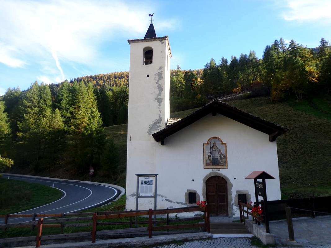
Chapel of St. Nicolas (1447m).
Now we have to visit La Thuile and then proceed to the "little". If we come from the Colle San Carlo, after we meet, leaving to left the
Santa Anna Chapel at the Moulin, the
Chapel of San Rocco, where a plaque on the wall of the front side recalls that was built in 1630 for praying the Holy to expel the scourge of plague. It was restored in 2007 dall'A.N.A. or National Alpine Troops Association. Just below a small parking lot before the
Parish Church of St. Nicholas. A long history, which began in the year 800 with the same dedicated to the cult of
San Defendente, Patron Saint of the terrible danger of avalanches that upset the whole valley. Destroyed, it was rebuilt in 1732 but his life turned short because in 1794 the French troops, which already foreshadowed the arrival of Napoleon Bonaparte in 1800 (though it passed with a surprise through the
"Great"), have burned. It was rebuilt in part dedicated to Saint Nicholas, Holy beloved by Saint Bernard of Menthon later founder of the two Hospices, ignoring that the real Patron Saint of La Thuile was in ancient times St. Bartholomew. Perhaps for this reason it was never lucky and signs of ancient edifice remains only the wooden crucifix, between the choir and the nave, also escaped the looting of the French, while they disappeared the ancient frescoes and paintings, and the two wooden altars to most recent work of Artists and Craftsmen of the Savoy. A
"disaster", the French one, also witnessed by the nearby
Chapel of Sainte Barbe, where a plaque affixed always by A.N.A. in 2011, the year of its restoration. Open to visitors, the encounter the same with a small detour to the left, just past the bridge on the main road to Petit Saint Bernard (beautiful view on Grande Assaly). Just above and a little further away by the village of Petite Golette, it is the
Chapel of Grande Golette with a circular window below a tiny bell tower, from which a small and ancient stone bridge leads (but currently closed for renovation) on the highway. Continuing on that, after five wide turns, you reach Pont Serrand (
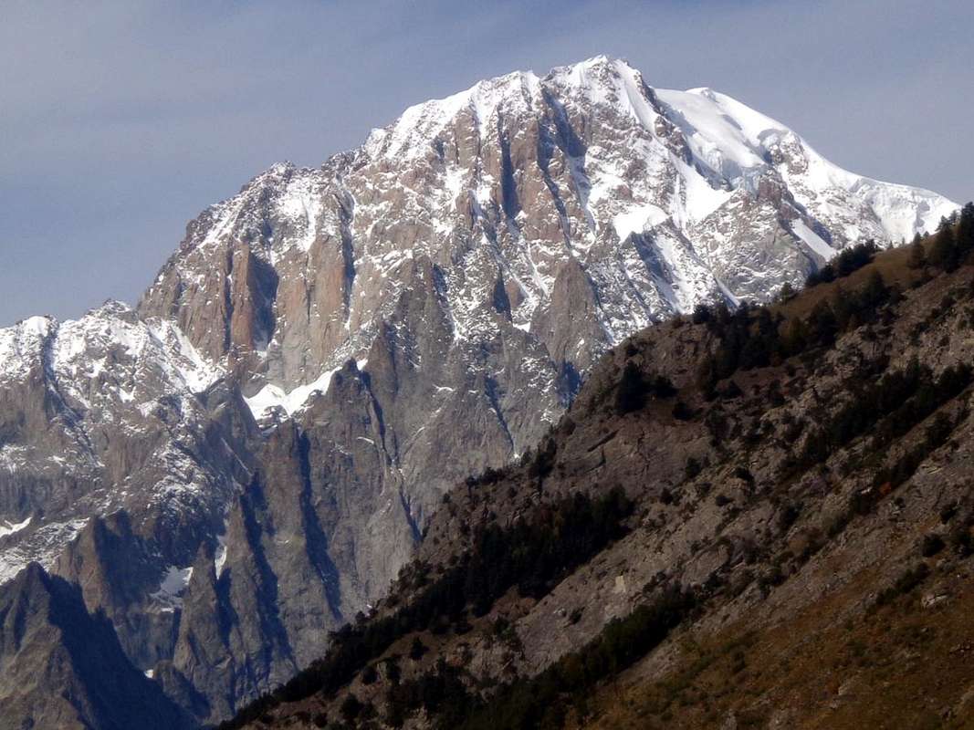
1602m; Chapel of Saint Bernard d'Aoste), placed in a very narrow gorge over Torrent de Verney with a fountain near the parking and spledid pano on the West Face Mont Colmet
(3024m).
From La Thuile towards the Little Saint Bernard, by Egidio Ferronato 1965, Ilario Antonio Garzotto 1969 & Osw 2015
Anche due sono le possibilità per recarsi Valle di La Thuile:
1)- Infine per concludere il nostro viaggio d'una settimana o, volendo visitare più attentamente i luoghi, qualche giorno in più dobbiamo nel pomeriggio, dopo avere visitato la Valgrisa in mattinata, concludere con quella di La Thuile. Andando magari fino al Colle del Piccolo San Bernardo
(2188 m) al confine con La Rosière
(1942 m) in Tarentaise, ormai in suolo francese. Per ciò fare abbiamo a disposizione, come per la Valgrisa, due soluzioni offerenti però questa volta un collegamento più logico passando in alto, ovvero tramite il Colle San Carlo
(1971 m), posto tra i Comuni di Morgex e La Thuile e lasciando più ad Occidente quello di Pré Saint Didier sotto la Tête d'Arpy
(2017 m) ad Est ed il Mont Crammont
(2736 m) sull'opposto versante. Scelta, come vedremo al punto successivo, che può essere anche effettuata con percorso inverso, cioé da Pré St. Didier a Morgex.
Lasciando la Strada Statale n° 26 presso la rotonda che precede lo ingresso nel centro del Comune di Morgex si passa la Dora Baltea sul ponte subito a Sud del medesimo incontrando quasi subito, oltre che le indicazioni in colore marrone per il Colle San Carlo, la
Cappelletta di San Rocco tra i piccoli Villaggi di Liarey e Pautex raggiungendo poi quelli di Pre Villair
(929 m), Biolley (sotto la
"Palestra di Roccia"), Tirecagne, Kiriaz, Jaccod e l'importante Villaggio di Arpy all'ingresso dell'omonimo vallone (
1680 m; Cappella "Notre Dame des Neiges". Da qui la Strada Regionale con un lungo diagonale verso Sudovest alle boschive pendici Orientali della Testa d'Arpy raggiunge il Col San Carlo
(1971 m; "Hôtel La Genzianella"). Da questo punto sono possibili due brevi escursioni o, per meglio dire, passeggiate conducenti con facili percorsi ma altamente panoramici verso:
c)- con sentiero
non numerato concomitante alla poderale verso Nord-nordest al famoso
"Belvedere" (grandiose vedute sul Monte Bianco e sulle Grandes Jorasses fino all'Aig. de Leschaux a Nordovest e Nord e sull'intera Valle Centrale della Dora fino a Châtillon) ed alla appena soprastante Croce della Tête di Arpy (
0h'40 tra andata e ritorno).
d)- Mentre verso Sudest (appena dietro la fontanella in legno presso i pannelli di segnalazione) parte attraverso la fitta foresta il sentiero
n° 15, sempre concomitante ad un'altra poderale in direzione del Lago di Arpy
(2063 m), posto alle pendici Occidentali della Becca Pouegnenta
(2675 m) nonché a quelle Settentrionali della Punta Nord del Mont Colmet
(3020 m), con vedute grandiose, durante il tragitto, dal Dente del Gigante alle Grandes Jorasses (
2h'00/2h'15 tra salita e discesa, delle quali
1h'20 all'andata).
Non rimane che scendere dal Colle San Carlo con la Regionale che, passando attraverso le
"Trincee del Principe Tommaso" a Petosan ed i Villaggi di Théraz, Granges
(1838 m), Preylion
(1552 m), Bouic
(1524 m), Thovex-Moulin, senza incontrar Chiese o Castelli ma con grandi vedute sui
Piloni del Monte Bianco comodamente porta a La Thuile.
Mont Belleface at entrance towards La Thuile, by Osw2)- Ma possiamo qui arrivare anche continuando sulla Statale n° 26 che da Morgex prosegue verso il successivo Comune di Pré Saint Didier, dove una Regionale, oltrepassato il ponte presso la
"Stazione Termale" (grandi vedute sul Versante Sudest del Monte Bianco), con ripidi tornanti supera
"furiosamente" il famoso
"Orrido di Pré St. Didier" per inerpicarsi poi decisamente verso una serie di gallerie anti-valanga insino a raggiungere il Villaggio di Elévaz (
1322 m; Cappella "Notre Dame de la Visitation") ed il successivo, dentro una temibile gorgia, di La Balme (
1309 m; Cappella di Sainte Marie Madeleine, due fontane del 1912). Attraversato subito appresso il ponte sulla Doire de La Thuile la strada, passando per il Villaggio di Revers
(1338 m), una Caserma abbandonata e la
Croce di Ste-Barbe, raggiunge la Thuile presso la
Cappella di St. Nicolas (1447 m).
Adesso dobbiamo visitare La Thuile e poi procedere verso il "Piccolo". Se arriviamo dal Colle San Carlo, subito incontriamo, lasciata a sinistra quella di
Santa Anna presso il Moulin, la
Cappella di San Rocco, dove targa sul muro della facciata frontale rammenta che é stata costruita nel 1630 pregando il Santo di allontanare il flagello della peste. Venne restaurata nel 2007 dall'A.N.A. o Associazione Nazionale Alpini. Appena sotto un piccolo parcheggio precede la
Chiesa Parrocchiale di San Nicola. Una lunga storia, iniziata nello anno 800 con la stessa dedicata al culto di
San Defendente, Santo protettore dal terribile pericolo delle valanghe che sconvolgevano tutta la valle. Andata distrutta, venne ricostruita nel 1732 ma la sua vita risultò breve poiché nel 1794 le truppe francesi, che già preannunciavano l'arrivo del Bonaparte nel 1800 (però passò a sorpresa dal
"Grande"), la incendiarono. Ricostruita in parte dedicandola a San Nicola, Santo prediletto da San Bernardo di Mentone poi fondatore dei due Ospizi, ignorando che il vero Santo Patrono di La Thuile fosse nei tempi antichi San Bartolomeo. Forse per questo motivo non fù mai fortunata e degli antichi segni rimane soltanto il Crocefisso ligneo, tra il coro e la navata centrale, scampato anche al saccheggio dei francesi, mentre sono scomparsi sia gli antichi affreschi e dipinti, sia i due altari in legno ad opera più recente di Artisti ed Artigiani della Savoia. Una
"sciagura", quella francese, testimoniata anche dalla vicina
Cappella di Sainte Barbe, con targa apposta sempre dall'A.N.A nel 2011, anno della sua restaurazione. Aperta e visitabile, la incontrate con una piccola deviazione a sinistra, appena oltrepassato il ponte principale sulla via del Piccolo San Bernardo (bella vista sulla Grande Assaly). Appena sopra ed un pò più in là, in località Petite Golette, si trova la
Cappella di Grande Golette con finestra circolare sotto un campaniletto, dalla quale un piccolo ed antico ponte in pietra riconduce (ma attualmente chiuso per lavori) sulla strada principale. Proseguendo sulla quale, dopo cinque ampi tornanti, si giunge a Pont Serrand (
1602 m; Cappella di Saint Bernard d'Aoste), posto in un'esigua strettoia sul Torrent de Verney con splendide vedute sul Versante Ovest del Mont Colmet
(3024 m).
La Thuile to Rutor Waterfalls below Deffeyes Shelter or to Little St. Bernard, by emilius 2004, Antonio 2004 & marco979 2008