By car:
- From TORINO, MILANO, etc: Motorway A5. Exit at IVREA or Quincinetto (PIEDMONT)
AOSTA West Villeneuve, Introd, Rhêmes Saint Georges, Notre Dame Municipalities.
![]()
St. Georges to Notre Dame, by Jorasses
From Aosta Town (East) or from Courmayeur-Resort (West), through the State Road number 27, towards Villeneuve (670m); also by the Motorway A5 from Aosta West (Aymavilles) or from Morgex to Arvier (776m) Communes. From those to the Rhêmes Valley, Introd (880m), Rhêmes Saint Georges (1171m), Rhêmes Notre Dame (1725m) Municipalities, through Main Road, up to the Thumel Village (1879m) with Municipal Road and Benevolo Refuge (2280m), through dirt road or path.
- From FRANCE: through the Mont Blanc Tunnel to Entrèves-crossroads to Vény/Ferret Valleys nearby Courmayeur.
![]()
Thumel Village from Northwest, by sarme
By Little Saint Bernard Hill, closed since November until half May to La Thuile Valley - Pré Saint Didier - Courmayeur.
It is not necessary to take Motorway A5: you can drive on State Road n° 26, in the direction of AOSTA - IVREA - TURIN.
By plane:
- Aeroporto Internazionale "Corrado Gex" Saint Christophe (Aosta)
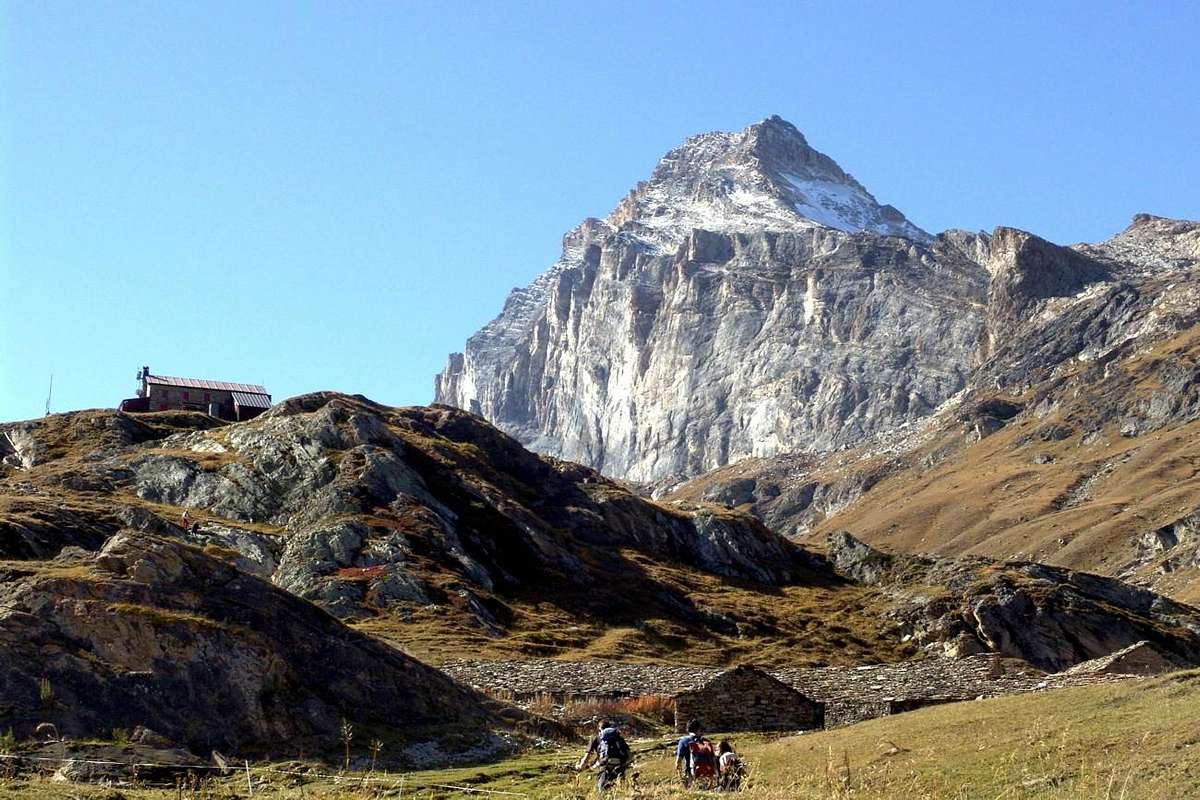
![]() Just below Benevolo Shelter, by emilius
Just below Benevolo Shelter, by emilius
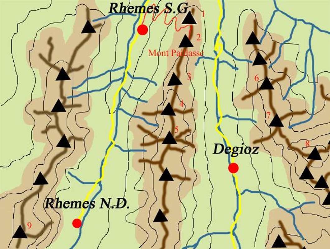
North towards South visiting five Commons
![]() Starting by Aosta City, arrived in Aymavilles, you have to keep going to the West reaching the adjacent Municipality of Villeneuve
Starting by Aosta City, arrived in Aymavilles, you have to keep going to the West reaching the adjacent Municipality of Villeneuve (
656/65m; current
Church of Santa Assunta of 1782), while the ancient
Parish with Romanesque bell tower is of 1400. But most of the
Châtel Argent above the XI° Century with its
walled in ruins but with the
cylindrical Tower still present. It constructed of materials that came from the Roman road to Petit Saint Bernard. Owned by the Lords of Bard, then those of St. Pierre and the 1605 Leonardo Roncas, he was dismantled in the eighteenth Century to rebuild homes after a violent storm. From the square of the Church apart from the Regional Road to the Municipality of
Introd, reached just after the bridge is
70 metres above a frightful ravine (
872m; magnificent
Château d'Introd of 1260 with internally Square tower and Roman Barn; Church of 1500 and Bell Tower 1600). The castle was built by Peter Introd Bard and restored in the twentieth Century. But before we get to Introd and after the Hamlet of Junod in that of Villes are in the feature Dessous (
806m; Chapel of St. James of 1867 with three mini Bell Towers topped by many Crosses), while proceeding as well as the Dessus (
863m; Church San Ilario).
Rhêmes Valley denotes signs of his "Christianity" a little bit everywhere, starting from the small village of Branloz at its entrance (
1050m; Chapel ) to that of Sarral (
1093m; Chapel ), just before the Municipality of
Rhêmes- Saint-Georges. A short climb with detour first to the South and then to the North leads to the Town Hall
(1234/5m), next to which we find the beautiful
Church of St. George of 1500 , rebuilt over a
Chapel of the XII° Century. Then transformed into a Rectory and Parish, has inside
wooden Altars of the seventeenth Century and a painting of the Death of St. Joseph; outward instead the adjoining ancient cemetery with burials on a single green grass and topped by old and artistic
wrought iron Crosses. Going up the valley floor, two short detours to the West lead to Frassiney (
1315m; Chapel) and Proussaz (
1445m; Chapel), two Villages perched at the foot of the wild
Grand Revers (3163m)). After the subsequent of Creton, Barmaz, Melignon, Brennan, Artalle, Carré (
1664m; Chapel) and Chanavey you reach the Capital of
Rhêmes-Notre-Dame (
1722/5m; Parish Church of Breuil and Romanesque Bell tower with the interior of the loudest bells in all the Aosta Valley), located at the foot of the large (
almost 2000 metres) Eastern Wall of the
Grande Rousse (3607m). Immediately following ancient cemetery with
wrought iron Crosses, which also rests
Casimire Thérisod (* 1858 + 1921), famous and first Mountain Guide of the Rhêmes Valley; a plaque, placed in 1921 by his Friends Mountaineers of Turin C.A.I. Giovanni Bobba Francesco Quaini, remembers him in main face of Town Hall right in front.
Rhêmes-St.-Georges towards Rhêmes-Notre-Dame below Grande Rousse, with Casimire Thérisod plaque,
by Osw 2015Partendo da Aosta, arrivati al Comune di Aymavilles, bisogna proseguire sempre ad Ovest raggiungendo l'adiacente di Villeneuve (
656/65 m; attuale
Chiesa di Santa Assunta del 1782), mentre l'antica
Parrocchia con Campanile Romanico é del 1400. Ma soprattutto il soprastante
Châtel Argent del XI° Secolo con la sua
cinta di mura in rovina e la
Torre cilindrica ancora presente; costruito con materiali romani che provenivano dal disfacimento della strada
"Consiliare" del Piccolo San Bernardo. Di proprietà dei Signori di Bard, successivamente di quelli di St. Pierre e dal 1605 del Nobile Leonardo Roncas, venne smantellato nel XVIII° Secolo per ricostruire le case dopo un violentissimo uragano con grandi distruzioni. Dalla piazzetta della Chiesa parte la Strada Regionale per il Comune di
Introd, che si raggiunge subito dopo il ponte alto
70 metri sopra uno spaventevole orrido nella Dora (
872 m; splendido
Château d'Introd del 1260 con internamente Torre quadrata e Granaio Romano; Chiesa del 1500 e Campanile del 1600). Il Castello venne costruito da parte di Pietro Introd di Bard e restaurato nel Secolo XX°. Ma prima di arrivare ad Introd e dopo la Frazione Junod in quella di Villes troviamo a Dessous la caratteristica (
806 m; Cappella di San Giacomo del 1867 con tre mini campanili sormontati da altrettante Croci) mentre procedendo oltre a Dessus la (
863 m; Chiesa di Sant'Ilario).
La Valle di Rhêmes denota segni della sua "Cristianità" un pò dovunque, incominciando dal piccolo Villaggio di Branloz al suo ingresso nella parte inferiore (
1050 m; Cappella) per arrivare a quello di Sarral (
1093 m; Cappella), appena prima del Comune di
Rhêmes-Saint-Georges. Una breve risalita con deviazione dapprima a Meridione e poi a Settentrione conduce al Municipio
(1234/5 m), accanto al quale troviamo la splendida
Chiesa di San Giorgio del 1500, ricostruita sopra una
Cappella del XII° Secolo. Trasformata successivamente in Rettoria e Parrocchia, presenta al suo interno splendidi
Altari in legno del XVII° Secolo ed una tela rappresentante la Morte di San Giuseppe; all'esterno invece l'attiguo antico cimitero con sepolture su di un unico verde prato e sormontate da vecchie ed artistiche
Croci in ferro battuto. Risalendo il fondovalle, due brevi deviazioni ad Occidente conducono a Frassiney (
1315 m; Cappella) ed a Proussaz (
1445 m; Cappella), due Villaggi abbarbicati ai piedi del selvaggio
Grand Revers (3163 m). Dopo i successivi Villaggi e Frazioni di Creton, Barmaz, Melignon, Brenan, Artalle, Carré (
1664 m; Cappella) e Chanavey si raggiunge il Capoluogo di
Rhêmes-Notre-Dame (
1722/5 m; Chiesa Parrocchiale del Breuil con Campanile Romanico con all'interno le campane, dicono per tradizione, più sonore e squillanti di tutta la Valle di Aosta), posta alle pendici della grande (
quasi 2000 metri) Parete Orientale della duplice
Grande Rousse (3607 m). Subito appresso antico cimitero con
Croci in ferro battuto, nel quale riposa anche
Casimire Thérisod (* 1858 + 1921), rinomata, famosa e prima Guida Alpina della Valle di Rhêmes; una targa, posta nel 1921 dai suoi Amici Alpinisti torinesi del C.A.I. Giovanni Bobba e Francesco Quaini, lo ricorda nella facciata del Municipio giusto affronte all'antica Chiesa Parrocchiale.
Then comes the moment of Mountains ..., by Osw 2015