All valleys have a Church, a Castle or Tower and even both or a Mountain with hallmarks. Characteristic for each that applies even to entire Aosta Valley.For every trip in each of them presents this trio almost unbreakable, because it represents the history, culture and traditions in the Centuries and Millennia to the firsts, and Eternity for the latest. When we think of a valley, immediately it comes to mind its highest mountain, or more beautiful that inevitably stands as a symbol of that. So for the Mont Blanc or the Grandes Jorasses in the two Courmayeur Vény and Ferret Valleys, Mont Velan and Grand Combins into the Great St. Bernard, Matterhorn in Valtournanche, Lyskamm in Ayas, Monte Rosa at the Lys Valley, Grand Paradis in Cogne and Valsavarenche, Grande Rousse to Val de Rhêmes, Sassière to Valgrisa and Rutor in La Thuile. But even those
"minor" flaunt their favorite mountain as the
Aouillette, Pointe Leissé, Fallère, Luseney, Viou, Faroma, Aver, Zerbion, Torché, Glacier, Rosa dei Banchi, Tersiva, Emilius or the tiny
Mont Greume above Vens. A combination that becomes even more distinctive if we add a Church, a Tower or a Castle that represent in terms Religious or what heraldic, chanting the History and the Life of the Population. One aspect that the Mountaineers,
"hasty" to reach the goal and yet ignore the Hikers preferring to leave out the majesty of the views or the exclusive admiration for Nature. Fall in this way into oblivion if not in total anything despite the remaining observations that these may be the key to understand the uses and customs of a place, always a bit different from each other. A total disregard for all that has kept alive a mountain, a valley or just a country. An oversight almost incomprehensible as unforgivable that we think to regain at least part of reviving the life of the mountains, always inscrutably still in place, with that of the
People who live at the base of the same, being born here, living and ending their journey ...
![]()
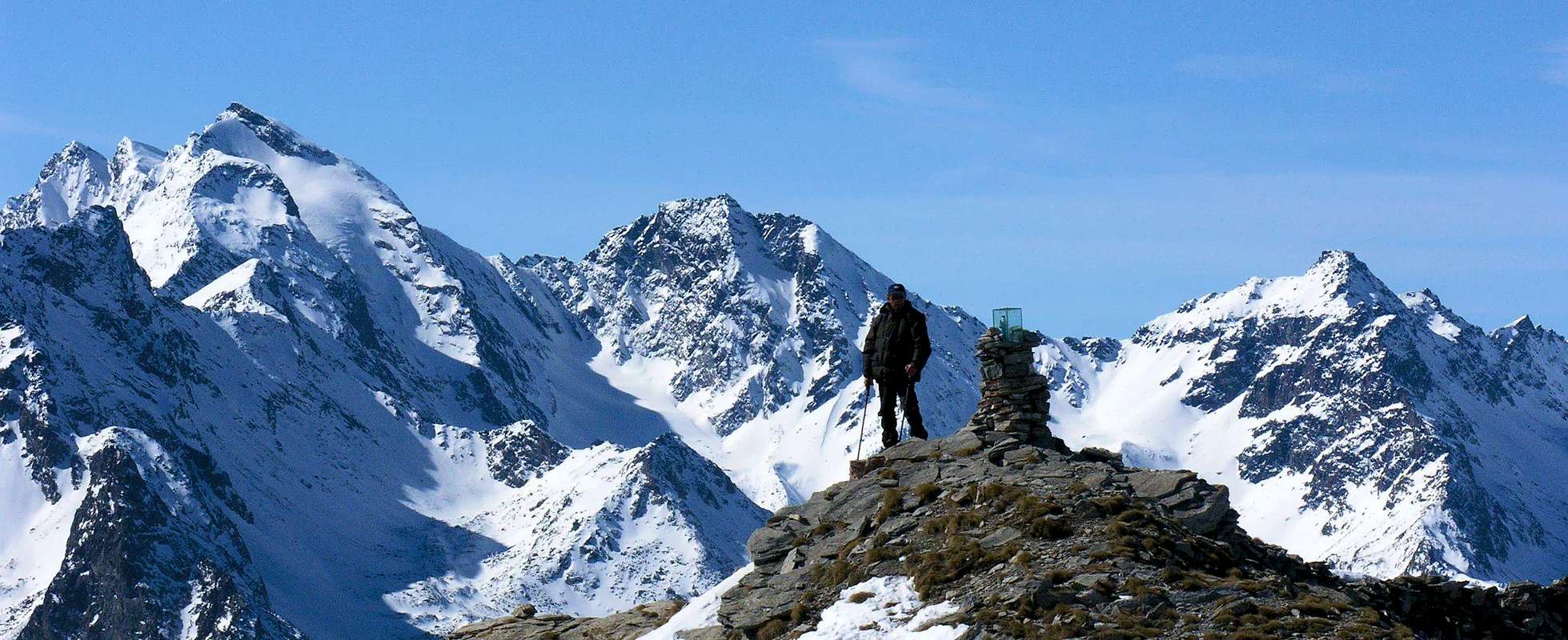
St. Nicolas Church nearby the "Bois de la Tour" in front of Punta Valletta,
by emilius
Le valli hanno una Chiesa, un Castello, una Torre od entrambe ed una Montagna che le contraddistiguono. Caratteristica per ciascuna valente pur per la Valle.
Infatti ogni viaggio effettuato in ognuna d'esse presenta questo trinomio quasi indissolubile, poiché rappresenta la storia, la cultura e la tradizioni nei Secoli e nei Millenni per le prime, nonché l'Eternità per le ultime. Quando pensiamo ad una valle, subito ci viene in mente la sua montagna più elevata o più bella che inevitabilmente si erge a simbolo della medesima. Così per il Monte Bianco o le Jorasses a Courmayeur, Mont Velan e Grand Combins al Gran San Bernardo, Cervino in Valtournanche, Lyskamm ad Ayas, Monte Rosa nella Valle del Lys o di Gressoney, Gran Paradiso a Cogne e Valsavarenche, Grande Rousse in Val di Rhêmes, Sassière a Valgrisa e Rutor a La Thuile. Ma anche quelle
"minori" ostentano la loro montagna preferita come l'
Aouillette, Pointe Leissé, Mont Fallère, Becche di Luseney e Viou, Monte Faroma, Becca d'Aver, Monte Zerbion, Becca Torché, Mont Glacier o Rosa dei Banchi, Emilius oppure il minuscolo
Mont Greume sopra Vens. Connubio che diventa ancora più caratterizzante se acciò aggiungiamo una Chiesa, una Torre o un Castello che le rappresentino sotto il profilo Religioso oppure quello araldico, scandendo la Storia e la Vita di quella Popolazione. Un aspetto che gli Alpinisti,
"frettolosi" di raggiungere la meta ignorano e che pure gli Escursionisti tralasciano preferendo la maestosità dei panorami o l'esclusiva ammirazione per la Natura. Cadon così nel dimenticatoio se non nell'oblio più totale le restanti osservazioni nonostante che queste possano costituire la chiave di volta per comprendere usi e costumi di una località, sempre un pò diversi l'un dall'altro. Una totale disattenzione per tutto ciò che ha tenuto in vita una montagna, una valle o semplicemente un paese. Una dimenticanza quasi incomprensibile quanto imperdonabile che pensiamo di recuperare almeno in parte riallacciando la vita delle montagne, sempre imperscrutabilmente ferme e piazzate al lor posto, con quella delle
Genti che vivono alla base delle medesime, qui nascendo, vivendo e concludendo il loro cammino ...
![]()
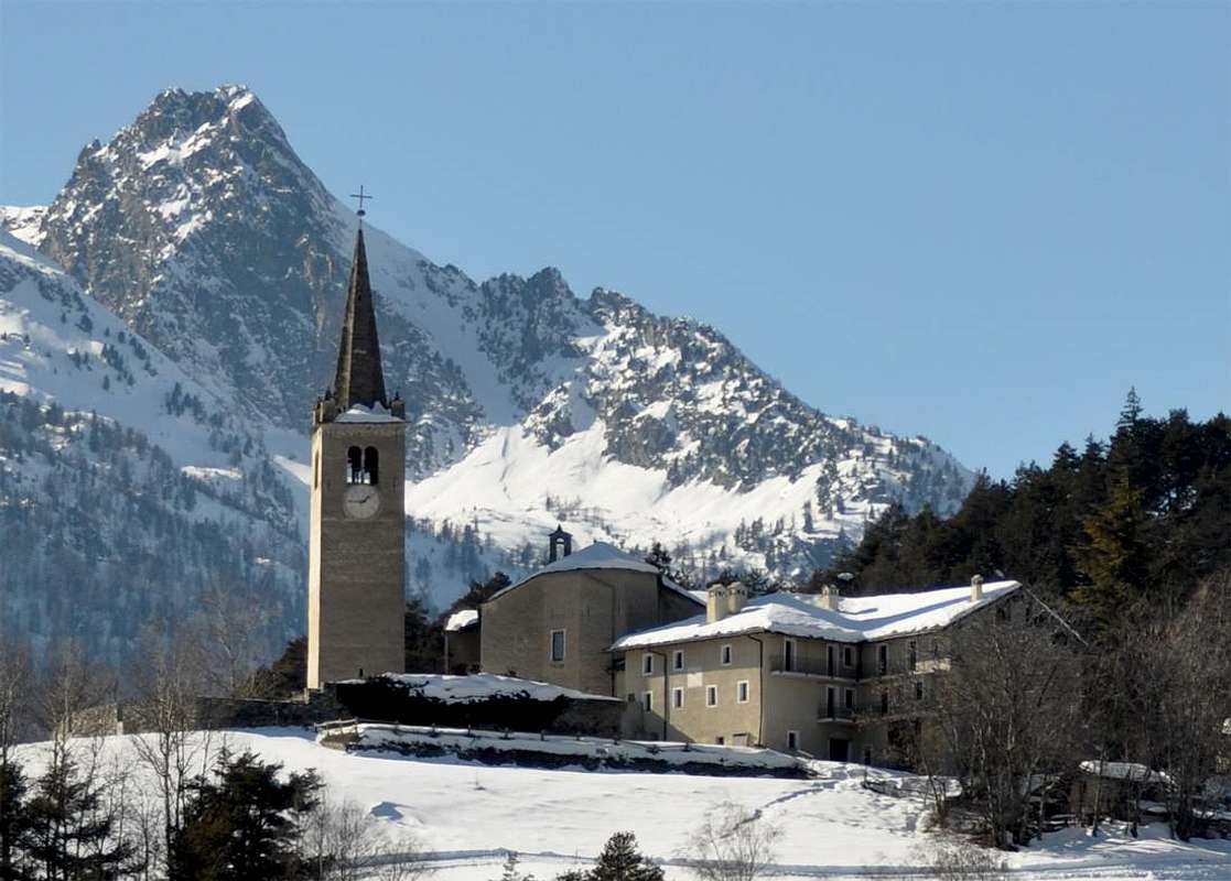
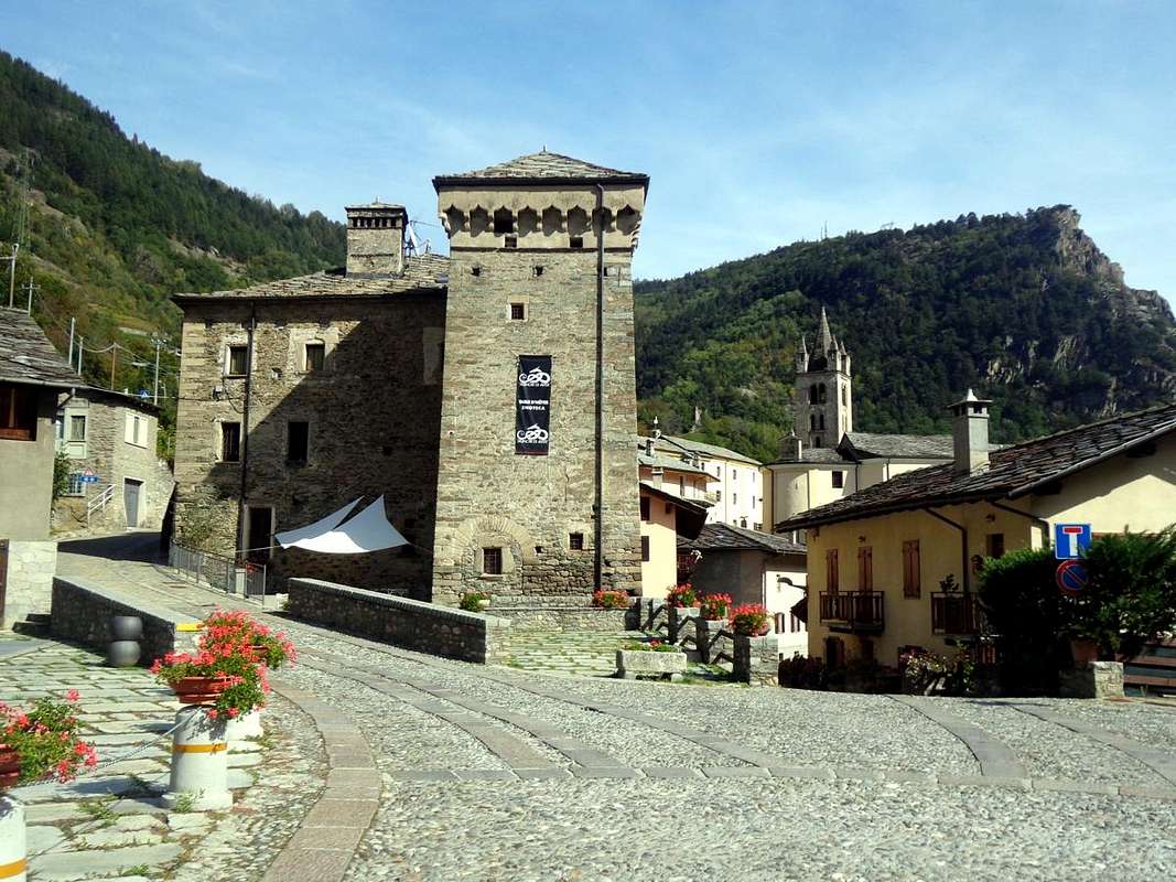
St. Nicolas Parish & "Cerlogne Museum",
by Maria Grazia Schiapparelli
After visiting the hill above La Salle Commune, we move further East towards Vens Hamlet and Vertosan Valley and the Basin Vetan until St. Nicolas Common.
All in the name of
V that rules in this area that faces, with in front of Grivola, Grand Nomenon and Punta Bioula, on the middle course of Baltea, immediately to the West of the City of Aosta and the neighboring Municipality of Sarre. A vast basin that extends from West to East, starting from the Court de Bard
(2261m) to reach the wooded and Southern slopes of Becca France. The area offers a wide range of climbing trips, hiking, ski-mountaineering or snowshoeing ranging from Punta Aouilletta to Leissé, Paletta, Monte Rosso and Mont Vertosan, and is this average share that we address, ie
from 2000 to 2800 metres, albeit from Vetan or Verrogne you can reach Mount Fallère
3061m), the highest Summit of this whole dock. Among these we choose excursion as a single Summit or
Becca France (2312m) that is Eastern end of this zone, also to allow for more trips or walks against hills or lakes or simple pastures with routes all in just one day and also on skis or snowshoes. This change to our proposal and allow more time available for the visit to the location of the lower or medium-low hill. Nothing prevents you from changing the destination, moreover not substantial differences because the ascent of this little Summit is equivalent in features and difficulties, which can vary only by choice of season and conditions. So a large proposal open to all and to every taste,
even if nobody forbids or prevents making of "jump" to the nearby Fallère here in plain sight .. .
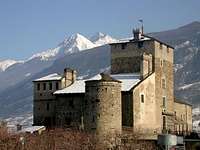
St. Pierre & Avise Tours and Castles,
by maria grazia s, Antonio & Osw
Dopo avere visitato la collina sopra il Comune di La Salle, ci spostiamo più ad Oriente verso Vens ed il Vallone di Vertosan e la Conca di Vetan fino a St. Nicolas.
Tutto all'insegna della
V che impera in questo settore che s'affaccia, con in fronte Grivola, Nomenon e Bioula, sul corso medio della Dora Baltea, subito ad Occidente della Città di Aosta e del limitrofo Comune di Sarre. Un vasto bacino che si allarga da Ovest verso Est partendo dalla Court de Bard
(2261 m) per raggiungere le pendici boschive e Meridionali della Becca France. Il territorio offre una larga gamma di gite alpinistiche, escursionistiche, sci-alpinistiche o con racchette da neve che vanno dalla Punta Aouilletta alle Leissé, Paletta, Monte Rosso e Mont Vertosan, ed é a questa quota media che ci rivolgiamo, ovvero
tra i 2000 ai 2800 metri, anche se partendo da Vetan o da Verrogne si può raggiungere il Mont Fallère
(3061 m), la Vetta più elevata di tutta questa area. Tra queste scegliamo come escursione un'unica Sommità cioé la
Becca France (2312m) all'estremità Orientale di questa amplia zona, anche per lasciar lo spazio ad altre gite o passeggiate nei confronti di colli, selle, laghi e laghetti oppure semplici alpeggi ed anche foreste con percorsi tutti effettuabili in giornata ed inoltre con gli sci o le racchette da neve. Questo per variar la nostra proposta e concedere più tempo disponibile anche per la visità alle località inferiori o della medio-bassa collina. Nulla vieta di cambiarne la meta, tralaltro senza sostanziali differenze poiché la salita di queste piccole Cime si equivale per caratteristiche e difficoltà da affrontare, che possono variare esclusivamente per scelta di stagione e relative condizioni. Quindi una larga proposta aperta a tutti ed a ogni gusto,
anche se nessuno vieta od impedisce di fare un "salto" al vicino Fallère da qui bene in vista ...
But also the "Bois de la Tour" with its "Belvedere" ...
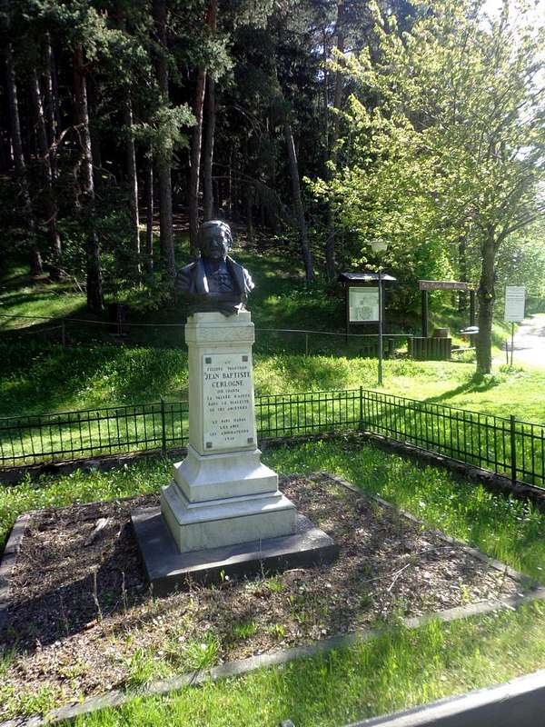
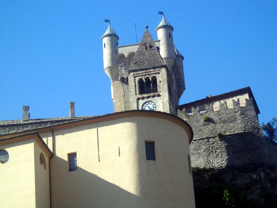
But in St. Nicolas you find, at the Parish Church with its old cemetery, also the "Bois de la Tour" with Orienteering trail and an adjacent splendid "Belvedere".An interesting route for school children and boys that here argue the races in the open air in a wonderful forest that entirely covers a rounded rocky promontory. An easily traced and quickly reached from St. Nicolas, passing, at its entrance, in front of the bust of the great poet in dialect
"patois" or Franco-Provencal, a native of a small village just above where it has remained his old house. To him each year is spent in schools a competition, well known throughout the Valley of Aosta. His tomb is there at your doorstep in front of the
Parish Church with Steeple frontispiece with its ancient cemetery. From this the Pastor managed to escape the Nazis
"throwing down" himself on the cliffs to the South of it and down to the
Dora Baltea. Nowadays, a marked trail and protected by wooden fences down this big rock leap. Just before the great
"Belvedere", true aerie toward the
Grivola (3969m), the
Punta Bioula (3413m) and
Becca del Merlo or Chamin (2961m), while in Southeast widens the complete
Mont Emilius (3559m) Group over Aosta City and the Pila Basin, offset by the opposite side from the expanses of the great
Rutor Glaciers. An unique not reproducible reward of this little beautiful Stroll.
Paying well attention to children ...
Ma a St. Nicolas trovate, presso la Chiesa e relativo cimitero antico, anche il "Bois de la Tour" con percorso d'Orienteering ed attiguo e splendido "Belvedere".Un itinerario interessante per i ragazzi delle scuole che qui disputano delle gare all'aria aperta in una meravigliosa foresta che ricopre interamente un promontorio roccioso rotondeggiante. Un tracciato facilmente e rapidamente raggiungibile da St. Nicolas, passando, al suo ingresso, davanti al busto del grande poeta in dialetto
"patois" o Franco-Provenzale, nativo di un paesino appena qui sopra dove é rimasta la sua vecchia casa. A lui ogni anno viene dedicato nelle Scuole un concorso, molto conosciuto in tutta la Valle di Aosta. La sua tomba é lì a due passi davanti al frontespizio della Chiesa Parrocchiale con il suo antico cimitero. da questa il Parroco riuscì a sfuggire ai nazisti
"lanciandosi" giù per gli strapiombi a Sud della medesima e verso la Dora Baltea. Oggigiorno un sentiero segnalato e protetto da staccionate in legno scende questo grande salto roccioso. Appena prima del fantastico
"Belvedere", vero nido di aquila verso la Grivola, la Bioula e la Becca del Merlo, mentre a Sudest si allarga il Gruppo del Monte Emilius sopra Aosta e la Conca di Pila, controbilanciato dallo opposto lato dalle distese dei grandi ghiacciai del Rutor. Una vista unica e non riproducibile ricompensa di questa piccola Passeggiata.
Facendo attenzione ai bambini ...
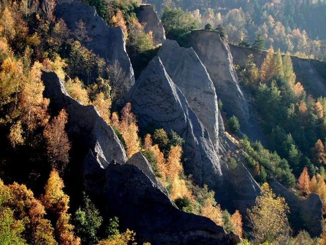
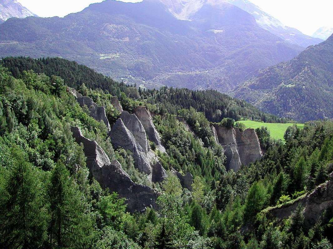
Even Towers Castles Museums & "pyramides calcaires" or limestone pyramids said "calanques"
Reached St. Pierre with Castle before property Lords Bard's then Savoy (worth a visit for the exhibition hunting trophies of V. Emanuele II°) you get to Arvier.Just beyond you meet the Hamlet of
Leve or Liverogne (water mange or growling), where he arrived in a gorge the Doire de Valgrisenche (
Chapel of Rochefort, built on the ruins of an ancient castle). Continuing West you reach the deviation with daunting bridge to the underlying
Avise (
762/82m; Parish Church with Romanesque Bell tower; Oratory of Clapier in Comba Vertosan three castles and the most important of which is that of
Avise by Lords of Avise, 1492, built by Boniface squire by Henry IV°. Going up the hill meet the Cerellaz and Charbonnière Villages and then crossing to St. Nicolas you can see those erosion pyramids said
"calanques". A cultural journey as well as highly instructive that after a visit to the castles cited more to
Castle Sarriod de la Tour of XIV° Century built by Counts Sarriod de la Tour" at the entrance of St. Pierre Common, can only be a unique opportunity for the boys before a good race
Orienteering to "Bois de la Tour" and an easy short Hike to the scenic mountains just above it.
Oh, and also an interesting visit to the small museums "Cerlogne" and "Working Tools" in St. Nicolas and the underlying small Village of Lyveroulaz ...
![]()
St. Pierre erosion limestone pyramids,
by Maria Grazia Schiapparelli
Raggiunto St. Pierre col Castello dei Signori di Bard e poi Savoia (merita una visita per l'esposizione dei trofei di caccia di V. Emanuele II°) s'arriva ad Arvier.
Appena oltre si incontra la Frazione di
Leve o Liverogne (acqua che rogna ovvero che brontola), dove arriva in una forra la Doire de Valgrisenche (
Cappella di Rochefort, costruita sui resti di un antico castello). Proseguendo ad Ovest si giunge alla deviazione con ardito ponte per la sottostante
Avise (
762/82 m; Chiesa Parrocchiale con Campanile romanico; Oratorio di Clapier nella Comba di Vertosan e tre castelli il più importante dei quali é quello d'
Avise del 1492 dei Signori d'Avise, costruito da Bonifacio scudiero d'Enrico IV°. Salendo sulla collina s'incontrano i Villaggetti di Cerellaz e Charbonnière e poi verso St. Nicolas si posson ammirare le piramidi d'erosione dette
"calanques". Viaggio culturale nonché altamente istruttivo che, dopo una visita ai castelli citati più quello di
Sarriod de la Tour del XIV° Secolo all'ingresso di St. Pierre, non può che essere un'occasione unica pei ragazzi prima d'una bella gara d'
Orienteering al "Bois de la Tour" ed una facile Escursione verso le panoramiche montagne soprastanti.
Ah, dimenticavo, interessante anche la visita ai piccoli Musei "Cerlogne" e degli "Attrezzi di Lavoro" a St. Nicolas ed al sottostante Villaggetto di Lyveroulaz ...
![]()
St. Pierre "Calanques",
by livioz
Saint Pierre or Avise Getting There
By car:
- From TORINO, MILANO, etc: Motorway A5. Exit at IVREA or Quincinetto (PIEDMONT)
From IVREA Town: in West (Southern side) to Pont Saint Martin, Donnas, Bard, Aymavilles, Villeneuve, Saint Pierre, Arvier and Avise Municipalities.
From Courmayeur Resort: in East towards Morgex, La Salle, Avise, Arvier and Saint Pierre.
![]()
From Courmayeur in East or by Aosta City in West towards Avise St. Pierre St. Nicolas Commons
From Saint Pierre-Pommier (783m), Champretavy, Rumiod, alternative just after Persod (1351m), Ravoise, Chaillod, Clavel, Cerlogne (1580m) to Vens small Villages (1750m), with Regional Road in West-northwest. From this last to Joux Saddle (1930m): through short descent to Vertosan Vallon.
From Saint Pierre-Chateau Sarriod de la Tour, Rumiod, Petit and Grand Sarriod (1444/5m), Gerbore, Vetan Dessous (1670m) and Dessus (1737m), with Regional Road to Vetan Basin. From this, through dirt road, towards Genevrine Pasture, Chatalanez, Toules, Grand Arpilles Alps to Chaz Creuse Alp (2398m).
From Avise (762/82m) Common to above Cerellaz and Charbonnière (1254m, 1263m) small Villages by a Regional Road with subsequent crossing towards St. Nicolas.
![]()
- From FRANCE: through the Mont Blanc Tunnel to Entrèves-crossroads to Vény/Ferret Valleys - Mountain Guides of Courmayeur - La Saxe Rock Gym - Courmayeur. By Little Saint Bernard Pass, closed since November until half May to La Thuile Valley - Pré Saint Didier - Courmayeur.
It is not necessary to take Motorway A5: you can drive on State Road n° 26, in the direction of AOSTA - IVREA - TURIN.
By plane:
- Aeroporto Internazionale "Corrado Gex" Saint Christophe (Aosta)
Some Walk Hike & Orienteering Easy
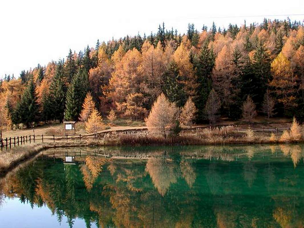
![]() Joux Pond near Joux Saddle above Vens Village, by maria grazia s
Joux Pond near Joux Saddle above Vens Village, by maria grazia s
1)- Leyser Loch through Joux Saddle from Vens Hamlet at the beginning of Vertosan Vallon passing through the Pond and Mont Joux from Vens small Hamlet.
By the Municipality of Saint Nicolas climb with the carriage road to the overlying Fractions or small Villages of Fossaz (1242m), Clavel, Cerlogne (1580m) until Vens (1750m; + small Church). From here to the Northwest trail n° 19 that goes up to the Saddle of Joux (1930m) just before crossing the lake of the same name (1907m), located immediately at the foot of Mont Joux (1978m; T/F; 1h'10/1h'30). From this collar, he left left the farm dirt road that leads down to the long Vertosan Valley, continue rather more to the North through a secondary dirt road concomitant with the previous path reaching the Pastures of Bettex below the Punta Aouilletta (+; 2616m); from these, more flexing in Northeast reach the point 2041 metres, past the Torrents Rognette and Leysser, where the same ends and only continues as the path. Reaching a height of 2106 metres in Pian Leysser soon reach the lake of the same name located at the feet of Monte Rosso of Vertosan (2418m; E/F; 1h'30/1h'45 from Sella; 2h'45/3h'15 in total).
2)- Excursion by Vetan-Dessus towards the Alps Grand Arpilles below Punta Leissé and Chaz Creuse at the foot of Aouilletta or directly to the last from Fossaz.
Leaving the West branch towards Vens Hamlet, continuing instead to the right reaching Grand Sarriod, Gerbore, Vetan Dessous and Dessus (1445m, 1633m, 1670m, 1737m) Villages and Resorts. From this last part a farm dirt road to the North in some places concomitant with the path n° 13, passing through the Thoules Pastures (1944m), reaches to Grandes Arpilles more great Alpage (2091m; T/F; 1h'15/1h'30) on the Southern Slope of Punta Leissé (2771m). Abandoning to right, the branch that leads through the little and narrow collar 2206 metres in the Vallon of Verrogne, continuing instead with the farm road to the West first reaching the crossroads 2237 metres at Alpe Pesse Damon; from this, more flexing Northwest to the small Vallon of Gaboé you reach the torrent of the same name. Forded the same in a short time you reach the small, characteristic and isolated Alpe Chaz Creuse or Tsecreousa (2398 m; E/F; 1h'20/1h'40), collocated at the grassy-rocky feet of Eastern Slope of Punta Aouilletta (+; 2616m).
![]()
Joux Saddle above Vens Village towards Vertosan Vallon, by emilius
3)- Walk St. Nicolas towards Chaillod, Fossaz Hamlets and Darbelley Pasture with Ascent to the North on Mont Greume (1821m) just West by Comba Mallaley.
From St. Nicolas, passing through Chaillod (1218m) through the paths n° 25/26A or more to the West by Fossaz (1242 m) Villages, go up to the North with the trail n° 26, passing through the Alpe Darbelley (1566m); this via a path unnumbered you can easily reach the small and wooded Mont Greume (1821 m; TE/F; 1h'45/2h'15). Here you can also get with start more from the East or by the small Village Gerbore (1633m; Chapel), immediately above St. Nicolas, with diagonal trail n° 17 (E/F; 1h'00/1h'10).
![]()
From Joux Saddle below Aouilletta towards Vertosan Valley, by livioz
1)- Al Lago Leysser nel Vallone di Leysser attraverso il Laghetto, la Sella ed il Mont Joux partendo dal Villaggetto di Vens all'ingresso nel Vallone di Vertosan.
Da Saint Nicolas salire con la strada carrozzabile verso le soprastanti Frazioni o Villaggetti di Fossaz
(1242 m), Clavel, Cerlogne
(1580 m) fino a raggiungere Vens (1750; + Chiesetta). Da qui parte verso Nordovest il sentiero
n° 19 che sale alla Sella di Joux
(1930 m) oltrepassando appena prima l'omonimo laghetto
(1907 m), collocato subito ai piedi del Mont Joux (
1978 m;
T/F; 1h'10/1h'30). Dal colletto, lasciata a sinistra la poderale che scende verso il lungo Vallone di Vertosan, continuare invece maggiormente a Settentrione con quella concomitante al precedente sentiero raggiungendo gli Alpeggi di Bettex al di sotto della Punta Aouilletta
(+; 2616 m); da questi, flettendo più a Nordest raggiungere il punto
2041 metri, oltrepassando i Torrenti Rognette e Leysser, dove la stessa termina e prosegue solo il sentiero. Raggiunta la quota
2106 metri nel Pian di Leysser in breve si raggiunge l'omonimo lago collocato sotto il Monte Rosso di Vertosan (
2418 m;
E/F; 1h'30/1h'45 dalla Sella di Joux;
2h'45/3h'15 complessivamente).
2)- Escursione da Vetan-Dessus all'Alpi Grandes Arpilles sotto la Punta Leissé e Chaz Creuse ai piedi dell'Aouilletta o a quest'ultima direttamente da Fossaz. Lasciata ad Ovest la diramazione verso Vens, continuare invece verso destra raggiungendo Grand Sarriod, Gerbore, Vetan Dessous e Dessus
(1445 m, 1633 m, 1670, 1737 m). Da quet'ultima parte una strada poderale verso Settentrione che in alcuni tratti concomitante al sentiero
n° 13, passando per l'Alpe di Thoules
(1944 m), raggiunge quella di Grandes Arpilles (
2091 m;
T/F; 1h'15/1h'30) alle pendici Meridionali della Punta Leissé
(2771 m). Lasciata a destra la diramazione che porta tramite il colletto
2206 metri nel Vallone di Verrogne, si continua invece con la strada poderale verso Occidente raggiungendo dapprima il bivio
2237 metri presso l'Alpe Pesse Damon; da questo, flettendo più a Nordovest verso il Valloncello del Gaboé si raggiunge l'omonimo torrent. Guadato il medesimo in breve tempo si raggiunge la piccola, caratteristica nonché isolata Alpe di Chaz Creuse o Tsecreousa (
2398 m;
E/F; 0h50/1h10 dall'Alpeggio di Grandes Arpilles;
2'10/2h'30 da Vetan Dessus), ai piedi del Versante Est di Punta Aouilletta
(+; 2616 m).
![]()
Aouilletta or Aouillette Summit above Vens & St. Nicolas, by Antonio
3)- Passeggiata da St. Nicolas verso Chaillod, Fossaz e l'Alpe Darbelley con Ascensione a Nord al Mont Greume (1821 m) subito ad Ovest della Comba Mallaley.
Da St. Nicolas, passando da Chaillod (1218 m) con i sentieri n° 25/26A oppure più ad Ovest da Fossaz (1242 m), salire verso Settentrione con il sentiero n° 26, passando per l'Alpe Darbelley (1566 m); da questa tramite un sentierino non numerato si può raggiungere facilmente il piccolo e boschivo Mont Greume (1821 m; TE/F; 1h'45/2h'15). A questo si può arrivare anche dal Villaggio Gerbore (1633 m) con partenza maggiormente da Oriente sopra St. Nicolas con il sentiero in diagonale n° 17 (E/F; 1h'00/1h'10).
![]()
Climbing on Aouilletta towards Mont Blanc Mountain Chain, by Antonio