Trip Report
We hiked Wahpenayo peak in the Tatoosh range near Mt. Rainier for our second BOEALPS BCC Experience Outing.
At 6:30am, we met in the Longmire parking lot. We left the cars at about 7am, and followed the road across the bridge to the Eagle Peak Trailhead at 2800'. The trail began with patches of snow and eventually became fully snow-covered.
At 8am, at about 4100', we chose to depart from the trail (which was becoming increasingly hard to distinguish in the snow anyway) and kick steps following the south side of the river rather than take the large switchback shown on our maps. We continued following the river for about an hour. At about 4700' the river petered out and we switched to a 60 degree bearing, aiming for the saddle between Wahpenayo and Chutla. We passed loose-snow avalanche debris as we were climbing the open slope up to the saddle. We discussed the avalanche conditions, but as there was no new snow and the existing snow was old and heavy on a relatively shallow slope, we decided to continue.
At 10am, we reached the saddle at 5600'. From there we began traversing southeast along the ridge up to Wahpenayo. We had to climb over four or five false summits along the ridge. When the ridge took a final turn to the northeast, we traversed along the south side until we were just below the summit. There we found a very steep slope leading up to the summit with a bad runout over cliffs below, so we belayed a climber to set up fixed lines. The whole party reached the summit at 6250' at about 12pm. The day was clear enough for fantastic 360 degree views of the rest of the Tatoosh range and Rainier.
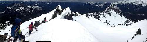
![wahpenayo-ridge]() A view of the false summits along the ridge, with Chulta and Eagle on the far right.
A view of the false summits along the ridge, with Chulta and Eagle on the far right.
At 1pm we began our descent, following the ridge back to the Wahpenayo-Chutla saddle, glissading down the slope from the saddle (one at a time due to the increased danger of loose-snow avalanches from afternoon warming), and following our tracks back to the Eagle Peak trail. We reached the cars at 4pm.
Google map of our GPS track here:
https://maps.google.com/maps?q=http://bcct4.lithven.com/Wahpenayo.kmz (there was a bit of a glitch on the way down; we actually followed exactly the same route).
Comments
No comments posted yet.