West Ridge of West Baldy

West Ridge of West Baldy

Page Type Page Type: Route
Location Lat/Lon: 51.00058°N / 115.05209°W
Additional Information Route Type: Scrambling
Seasons Season: Summer
Additional Information Time Required: Most of a day
Additional Information Rock Difficulty: Class 4
Sign the Climber's Log

Overview

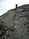
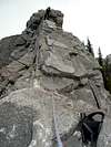
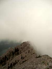
Mt. Baldy is a 2192m (7190ft) mountain in the front ranges of the Canadian Rockies. Mt. Baldy has 3 summits; Mt. Baldy, South Baldy and West Baldy. It is one of the first mountains you see as you drive to the mountains from Calgary. It is a very popular mountain for scramblers by Canadian Rockies standards. The most popular route to the summit is the east ridge to the summit of Mt. Baldy. It is described in Alan Kane's book, Scrambles in the Canadian Rockies. Alan Kane also describes a traverse to the summits of South Baldy and West Baldy by following a ridge to South Baldy and then climbing the east face of West Baldy. This route is the descent for the West Ridge of West Baldy. The West Ridge of West Baldy is described in Andrew Nugara's book More Scrambles in the Canadian Rockies. It is a great difficult scramble with a lot of scrambling and generally solid rock. I would not recommend this scramble if it's wet or snowy.

Getting There

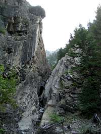
From Calgary follow the Trans Canada Highway for about 40 minutes to the turn-off for Highway 40 (Kananaskis Trail). Head south on Highway 40 for about 10 minutes to a "point of interest" called O'Shaughnessy Falls. Continue down the road for a few hundred metres to an obvious drainage on the east side of the road. Park here.

Route Description

View from the approach drainage
The last step in the drainage before heading to the ridge
View from the drainage of the big rock face
Sam heading up the rubble to the ridge
Heading up the ridge to the first difficult part
Me on the first difficult slab
Another slab section
Sam heading up the crux
The view of the west ridge from the summit
The upper Alan Kane route on West Baldy
The lower part of the Alan Kane route on West Baldy
From your car, head up the rocky drainage. Stay in the drainage, sometimes following faint trails. The drainage will become more rugged with small rock steps that you need to scramble up. Continue up for about an hour. The last step will consist of a little gully with downsloping rock that is difficult to climb. Some parties will bypass this gully on the right, which is easier but more time consuming. Above this step, there is a big rock face which extends to the summit. When you can clearly see this face, turn left and head up grass, treed and rubble slopes to the West Ridge. This will take around half an hour. From here head up the West Ridge, following a faint trail. The scrambling should be pretty easy in this section, just a few slabs and rubble. In another 20 minutes, you should reach the first real difficult section, a slabby arete with a piton a few metres up. If you want to use a rope this would be the place to don it. Continue up the ridge over 4-5 more slabby steps. Each one is about 25m high with ledges atop each one. Soon, you will arrive at the crux, it will be the steepest step yet. It has broken rock with lots of cracks and a small overhang where the rock transitions from white to dark grey. The overhang is the crux. The scrambling is not too difficult but it's quite exposed. Atop the crux there is a small ledge with a piton and a small dead tree. After the crux, there is 15m of exposed ridge and another slabby step. After this the scrambling becomes easy again and after a little more plodding you will arrive on the summit, which is marked by a cairn. For descent, you could return the same way which would be very difficult, or you can descend the East Face, the way the Alan Kane route comes up. If you want to descend the East Face, first you must backtrack a few metres from the summit to a cairn marking the route down. Then you must descend a gully for about 10m, at this point traverse skier's left across slabs to a ridge. From here scramble down rubble, slabs and rockbands to the col between West Baldy and South Baldy. There you should find a good trail that leads down the drainage to the north. Follow this trail all the way down the rubble slopes and back through forest to Highway 40. You will end up about 1km north of your car.

Essential Gear

Normal hiking gear, hiking boots and a helmet.
If you are uncomfortable scrambling 4th class and possibly very low 5th class, you should bring a rope, harness, amd a small rack.

External Links

Add External Links text here.