
|
|
Route |
|---|---|
|
|
39.23380°N / 105.2707°W |
|
|
Trad Climbing, Bouldering, Aid Climbing |
|
|
Spring, Summer, Fall, Winter |
|
|
Less than two hours |
|
|
5.9 (YDS) |
|
|
1 |
|
|
Getting There
Climb on!
Turn south on County Road 126 passing through the small towns Pine and Buffalo Creek.
Turn on Forest Road 211 (3 miles before Deckers)- look for the sign to Cheesman Reservoir. FR #211 is narrow and windy for the first 2 miles. The aftermath of the Hayman Fire is still VERY visible.
This road is maintained in winter - but be well prepared to drive on a narrow, icy road.
After two miles you reach a junction (marked by several oversized post boxes).
Proceed in the direction of Cheesman Reservoir (to your left), where you find two parking lots near the bottom of the road.
From Colorado Springs, drive west out of town on Hwy. 24 (Cimarron Avenue) towards Woodland Park. Take Hwy. 67 north out of Woodland Park driving towards Deckers.
A few miles past Deckers, look for FR #211 on the left side of the road. You should pass the Lone Rock Campground and the entrance to the "Wigwam Club" (private, but marked). If you pass the Wigwam Campground, you've gone too far.
Proceed to the bottom of the road almost to the reservoir itself. Park on the left in the small parking lot.
Route Description

Sarah Simon & Jess Meris
The Southern part of the main ridge of Cheesman Mountain is owned by the Denver Water company.
Trail regulations stipulate clearly that hikers have to stay on the trail - it can be assumed that the company is not in favour of hikers wandering around their property except on established trails.
What we found to be easiest was to park at the small parking lot located at the bottom of #211 near a gate and within view of the reservoir. This area is marked & signed.
Follow the trail for perhaps .5 mile until you are well on the south side of Cheesman Mountain. Take any number of shallow ravines or the mellow slopes hikers' left to the top of the easy south ridge.
You will see your objective at that point (very distinctive summit block). Simply follow the path of least resistance.
NOTE: There is a multitude of downed and burned timer and numerous yucca and other spiny/thorny things. Wear boots for the approach hike in.
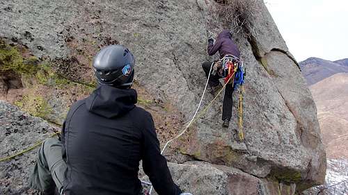
Climb:
This is only one pitch and at that, more of a tough bouldering problem really. Below the crux, there is an 8"-12" downward-sloping ledge in which to start the climb. This short route gets its' name from the 'wire-hanger' thick wire that someone wrapped around the upper chockstone.
Utilizing the loops that are bent into the wire, the lead climber can get a good six feet up the rock wall. From the ledge, the drop behind the lead climber to the ground below is about 25'. Keep in mind, it's not a clean fall. The ground is littered with various basketball & microwave-sized rocks, downfall and yet, more yucca.
- Climb the three rungs in the wire for a total of about six feet.
- Leave the wire on an ascending traverse climbers right at about 45°-55°.At this point, the lead will be very exposed to a fall as there is no where to place pro. Edge up the face using inside toes and fingertips. The only real pro the lead has is to keep the lead climber on a tight belay.
- The lower chockstone will be another 4' higher directly above at this point. Finger-jam the lower crack below the chockstone for a good hold while (possibly) kicking the right foot out on an open-faced flare for pressure.
- Pull up and reach over the top of the chockstone for a moderate lip/hold. It's a little bit of a reach for those with shorter arms but no problem for taller people.
- Easily mantle over the chockstone into the filled crack for an easy finish with ample holds. There are a 2-3 smaller chockstones above the lower.
- Set an anchor with the one sling/carabiners that are there and bring the others up! Rappel down.
- Bring two, 60-70m ropes, double-fisherman them together and throw one end over the top of the rock to the other side (this will undoubtedly take a few attempts). It's a bit of a drop off the south side. Secure the rope and jumar up the north side using jumars or mechanical.
- Forgo the wire and instead, climb straight up the face left of the wire. There are small holds, finger-width at most, going up this short face. In the advent of a fall, it's possible to catch the lead since the ledge is slightly wider farther to the left. But again, no protection.
Essential Gear
- 30m rope
- slings
- carabiners
- harness/ATC/locker
- ladders (for aiding)
- 1-2 C4's or friends (mod.) around #2