
|
|
Area/Range |
|---|---|
|
|
43.82598°N / 113.72583°W |
|
|
Hiking, Mountaineering, Scrambling, Skiing |
|
|
Spring, Summer, Fall, Winter |
|
|
11278 ft / 3438 m |
|
|
Overview
The White Knob Mountains are a high and dry range located between the Big Lost River Valley and Copper Basin in East-central Idaho. The range is quite compact being only about 30 miles long and 10 miles wide, yet it offers a great deal of amazing scenery and excellent peak bagging opportunities. There are several peaks topping 10,000 ft. with Shelly Mountain at 11,278 ft. being the range highpoint. Four peaks including Shelly rise to over 11,000 ft. and are in the state's 100 highest peaks. Shelly comes in at #65 while Redbird is at #67. Cabin Mountain is #74 and Lime Mountain is #79.Because they are situated between two of Idaho's most popular mountain ranges, namely the Lost Rivers and Pioneers, the White Knobs are often seen but seldom visited. The range's location does have its advantages- perhaps the best view to be had anywhere in Idaho awaits those who summit White Knob Peaks. On clear days no less than seven mountain ranges can be seen as well as the vast Snake River Plain to the South.
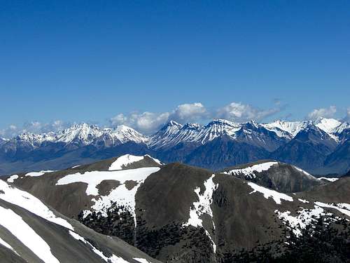 Lost River View
Another attractive characteristic of the White Knobs is the fact that many of the peaks, including the four 11ers, can be linked together for a long day of scrambling. The 10ers can also be linked for another long day trip. Because of the open terrain cross country travel is fairly easy, especially at higher elevations.
Access to the range can only be described as difficult. All approaches are long and involve high clearance, 4WD roads. There are only three maintained hiking trails in the range but with the increased use of ATVs in the area many more have been developed illegally. The higher reaches of the mountains remain mostly untouched.
With outstanding views, four peaks reaching higher than the 11,000 ft. mark, and four more above 10,000 ft. the White Knobs should be on every Idaho mountain enthusiast's list.
Climate
The White Knobs are a very dry range, being in the rain shadow of the Pioneers to the East. Because of this the mountains are open and mostly treeless. A great deal of the range is also above treeline further contributing to its open nature.
Where there are trees Limber Pine makes up the majority with a few Lodgepole Pines and Spruce trees here and there. There are also small pockets of Aspens and a generous amount of Mountain Mahogany covering the lower elevation slopes. Sagebrush is by far the dominant plant in the region.
Even thought the range is dry there are a number of alpine lakes and many streams on the Eastern side of the range. Alder Creek is perhaps the largest stream in the range and flows from a lake near the upper end of Stewart Canyon.
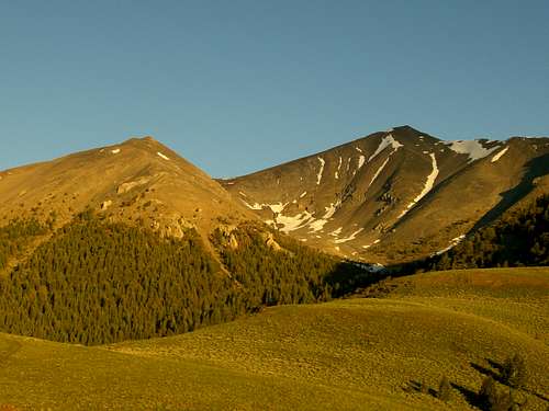 Morning Light on Shelly
Weather

Geology
The White Knobs are an extremely geologically complex range of mountains. The peaks are mostly giant piles of crumbling sedimentary rock but amazingly there are many granite intrusions. Because of the complex geology of the range it is loaded with many valuable minerals. Copper was discovered in the range in 1879. As a result the area has been mined since the late 1884 and is peppered with abandoned mine shafts, cabins, and equipment.
Regarding one old mining town in the range, Henry Chenoweth submitted the following info to this website. "White Knob Mountain was the source of millions of dollars of copper ore early in the 1900s. The first mine to start [was] the village of White Knob [and] was appropriately named the White Knob Mine. In time, the town grew to have stores, a post office, a boarding house, a school and even a theatre. Mining operations were on the east face of the mountain. A large, electric powered tramway was built to haul the ore down the mountain to the smelter and blast furnaces located in Mackay. Later, the Empire Railroad built a narrow gauge track that wound up the mountainside for nearly eight miles before reaching the mines. Most of the railroad grade can still be seen as well as the tram towers."
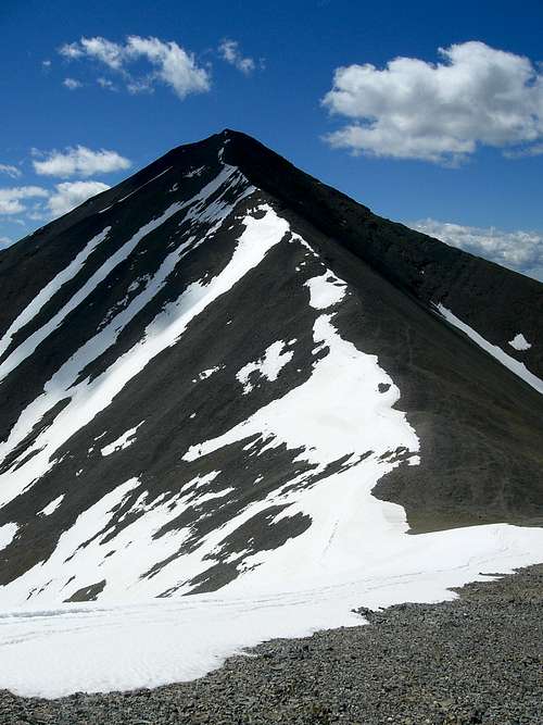 Shelly Mountain
More information on the region's geology.
Information about the Mackay Hill Mine
Peaks
| Peak | Elevation (ft.) | Class |
|---|---|---|
| 11,000+ ft. Peaks | ||
| Shelly Mountain | 11,278 | 2 |
| Redbird Mountain | 11,273 | 2 |
| Cabin Mountain | 11,224 | 2-3 |
| Lime Mountain | 11,179 | 2 |
| 10,000+ ft. Peaks | ||
| White Knob Mountain | 10,835 | 2 |
| Mackay Peak | 10,273 | 2 |
| Peak 10,201 | 10,201 | 3 |
| Porphyry Peak | 10,012 | 2 |
| 9,000+ ft. Peaks | ||
| Peak 9,988 | 9,998 | 2 |
| Wildhorse Peak | 9,938 | 1 |
| Sheep Mountain | 9,649 | 2 |
| Lupine Mountain | 9,554 | 2 |
| 8,000+ ft. Peaks | ||
| Castle Rock | 8,781 | 3 |
Getting There
Access to the White knobs can be tricky and tough. While the range can be accessed from both the East and the West, the primary route is from the east via Alder Creek Road. From the West the range can be reached from remote Copper Basin. The Whole Range
Alder Creek Road
Follow Highway 93 North from Arco until you reach the microscopic community of Darlington. Turn left on Smith road and follow it towards the hills to the West. Eventually it will turn to the north and become Dove Road. Anywhere the road splits always stick to the left (West). Just past a very remote ranch house it will finally turn into Alder Creek Road and will enter the Challis National Forest. From here on the road gets worse until it deteriorates into an ATV track leading to the 10,000 ft. summit at the head of Stewart Canyon.
 Mount Borah
Copper Basin
Head North from Arco on highway 93 until you come to the signed Antelope Creek Road. Turn left here and follow the road West for around 30 miles over Antelope Pass and into Copper Basin. The White knobs will be clearly visible to the East from Copper Basin and can be reached by any number of cross country approaches.
Red Tape
A 4WD, high clearance vehicle is required for all access routes into the range. Mine Shaft
 Ugly ATV tracks
There are no permits of fees of any kind to access this area.
Please remember to practice Leave No Trace
External Links
Challis National Forest, Lost River DistrictTrip Reports
Idahosummits Trip report
Splattski's Trip Report
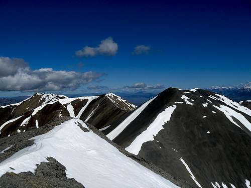 The 11ers from Shelly
Camping
There are no established campgrounds in the White Knobs but there are plenty of places to camp. Choose your site wisely and enjoy. Mirror Lake