
|
|
Mountain/Rock |
|---|---|
|
|
43.92730°N / 114.0845°W |
|
|
9546 ft / 2910 m |
|
|
Overview
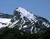
Wildhorse Peak forms the northernmost corner of the White Knob Mountains of central Idaho. It is located between the Lost River Range and the Pioneer Mountains, providing excellent views of the core peaks of each range. While dwarfed by its larger, more rugged neighbors, this peak provides a great vantage point for beautiful mountain views in all directions.There is an old forest service lookout at the top of the Wildcat Canyon trail. The altitude given in the USGS quad is 9,546 feet. There is a slightly higher point to the northwest but the lookout is the traditional summit. These valleys contain many things named Wildhorse, including a ranger station, ranch, and Wildhorse Canyon.Panoramic View
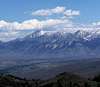
From the summit you have beautiful views of the Pioneer Mountains and Lost River Range, and other high ranges are visible including White Clouds, White Knobs, and Boulders. This is the largest collection of Rocky Mountain 11,000+ foot peaks north or west of Wyoming.
Click here for an area map.
"An excellent vantage point to view the surrounding country."
Tom Lopez - Idaho: A Climbing Guide
Tom Lopez - Idaho: A Climbing Guide
 | | | |
 |  |  |
Getting There
Wildhorse peak is easily accessible at the junction of Trail Creek Road and Wildhorse Creek Road. Coming from either the east or the west, turn onto the road to Wildhorse Canyon (there is an information kiosk across from the junction.) After about one mile follow the signs to Copper Basin (FR-135). After crossing a one-lane bridge, turn left just before a fence. If you pass a sign that says "river access," you have gone too far. Turn left onto a rough two-track road and park at a faint turnaround area.- Google maps:
- Directions from Boise
- Directions from Idaho Falls
Approaches from other directions are possible, but would be far more difficult. An approach from the north would include crossing the Big Lost River and navigating treacherous scree slopes. A far more pleasant but long approach would be from the south traversing the open crest of the White Knobs. This would involve miles of ridge walking.
 |  |
Red Tape
Other than automobile restrictions in Wildcat Canyon, there is no red tape here. Wildcat Canyon trail is maintained by the USFS as an ATV / pack trail.When To Climb
This peak is mostly snow free from April to October due to its low altitude and location in the rain shadow of the Pioneers. Year round climbing is possible with snowshoes / skis / snowmobiles. Trail Creek Pass to the west is closed during the winter, but Trail Creek Road is accessible from the east most of the year except after massive winter storms.Camping and Lodging
Camping areas nearby adminstered by Salmon-Challis National Forest: Nearby LodgingMountain Conditions
This peak is administered by the Lost River Ranger District of Salmon-Challis national forest, located in Mackay.Phone: (208) 588-2400