Blodgett Campground to Mill Point
![Blodgett Campground Trailhead]() The trail begins from this parking area.
The trail begins from this parking area. – 8,467’
Route Elevation Gain – 4,519 ‘
Distance – 8 miles
(round trip)
Difficulty – Class 2
Ascent Date – 28oct06
Total Route Time – 6.75 hours
Somehow Mill Point seems to have flown below my radar, that is until Torrey put up the mountain page on Summitpost and caught my attention. Since it is one of the peaks closest to our Bitterroot valley home, Linda and I decided to give it a go
I contacted Torrey for a bit of clarification about the location of the beginning portions of the trail from Blodgett Campground which he quickly provided. The weather looked like it would cooperate over the last weekend of October, so we set a date, Saturday, October 28, 2006.
![First Rest Period]() By this point we were warm enough to shed a few layers.
By this point we were warm enough to shed a few layers.
Even though the days are comparatively short this late in the year, we figured the outing, which we guessed to be about 8 miles in length, wouldn’t take so long that we’d have to begin at the crack of dawn. We took our time getting ready and had a lazy breakfast before driving to the trailhead.
9:45 am – We began hiking east on an obvious trail from the north parking area for the Blodgett Campground. Even with our late start, we were the only car in the lot, which was surprising given that the area is quite popular with rock climbers. I’d expected to see a few vehicles and climbers on such a fine morning.
![View Back Blodgett Drainage]() Looking west into Blodgett Canyon
Looking west into Blodgett Canyon
10:25 am – By now we’d followed the trail
(faint in places) around the lower end of the cliffs which comprise the north side of Blodgett Canyon, and had begun climbing steeply upward. A mile from the trailhead and we were beginning to get hot, real hot. We stopped to zip off the lower legs of our zip-off pants and shed our outer layer.
10:47 am – We reached the first overlook along our route and stopped to take a few pictures – and catch our breath.
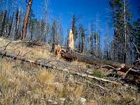
![Wind-downed Trees]() Wind-downed trees abound
Wind-downed trees abound
in the burned areas.
11:02 am – Mill Point was heavily involved in the fires of 2000. We reached the lower edge of the burn. Many of the fire-killed trees are beginning to fall. But the area is showing signs of a good recovery. From the amount of droppings present, it’s obvious the elk and deer population is spending plenty of time here. Small seedling trees are beginning to show through the covering of grass. Woodpeckers are using the trees to collect insects and make nests. All in all, I’d have to say the burn is recovering nicely.
11:25 am – Two miles from the trailhead, we reached 6,300’ elevation and another overlook. The west views into Blodgett Canyon are superb from here.
![Blodgett Drainage]() The ridgeline along the south side of Blodgett Canyon.
The ridgeline along the south side of Blodgett Canyon.
11:35 am – Just 10 minutes later and still close to the cliff edge, we got our first glimpse of the Mill Point Summit. Across a gully and along a ridge-crest south of Point 6850 we spotted an outcropping of rock with its own keyhole. Cool!
![Keyhole Rock]() Keyhole rock.
Keyhole rock.
From this point we took a fairly straight line
(northwest) toward Point 7648. In our attempt to find a straight line we moved away from the edge of the canyon and into very dense forest. I don’t recommend taking this line, and in fact, will not travel that way again. The forest is just too thick and full of deadfall. Vistas disappear. It’s not worth the few steps it saves.
12:28 pm – After emerging from the dense forest
(a few minutes earlier), we once again reached the north rim of Blodgett Canyon. Looking up along the ridge we could see the summit, much closer this time. West southwest from our vantage point, we could see the summit of Canyon Peak barely showing itself over the crest of the ridge along the south side of Blodgett Canyon. Most of the forest along this area on Mill Point was involved in the fires of 2000 but is showing many signs of recovery.
![First Glimpse of Mill Point]() First glimpse of the
First glimpse of the
Mill Point summit.
12:50 pm – Having passed Point 7648 our track turned in a more westerly direction as we followed the ridge-crest. We’d been on ever-deepening snow since reaching an elevation of 7,200’. By now it was 4”-5” deep. But most interesting to us were the wild animal tracks showing in the snow.
This entire area of the ridge is visited by a large population of ungulates, including Mule Deer (we saw more than 2 dozen, including a couple of rather large bucks with impressive antlers), Elk (lots of tracks and droppings), and Moose. (We saw the tracks of a Moose who followed the ridge upward toward the summit before turning off at about 7,800’ and traversing west into Blodgett Canyon.)
![Wolf Sign]() Tracks left by a BIG wolf. Tracks left by a BIG wolf. |
![Wolf Scat]() Wolf scat. Wolf scat. |
![Footprint]() Footprints. Footprints. |
![Windy Summit]() On the windy summit,
On the windy summit,
but just for a few minutes.
1:20 pm – We reached the summit and posed for a couple of pictures. Then we zipped the lower legs back on our pants and beat a hasty retreat back the way we came. It was just too windy to stay any longer, so windy in fact, it was difficult to even stand.
1:55 pm – By the time we reached 7,800’ we were out of the wind. We had a pretty good view of Tag Alder Lake 600’ below and northeast of our position. We stopped to eat a bite before continuing our descent.
![Off the Summit]() Out of the wind
Out of the wind
and time to eat.
3:05 pm – Near 7,400’ elevation I stopped to take a couple pictures down a huge gully dropping toward Blodgett Creek. It certainly looks like a possible way to climb to the Mill Point summit. Steep for sure, but it might prove to be fun. Maybe I’ll give it a try next summer.
3:15 pm – During our descent we stayed close to the ridge-crest. We'd decided we weren’t up to traipsing through a thick forest again. Before reaching Point 7172 I stopped to take one last picture of the summit. Then I put the camera away so we would make better time on the remainder of our trip back to our car.
![Possible Gully Route]() This huge gully could be a possible route from Blodgett Creek to the Mill Point summit.
This huge gully could be a possible route from Blodgett Creek to the Mill Point summit.
4:30 pm – Back at the trailhead, the daylight was beginning to fade in the depths of Blodgett Canyon, too low to get good pictures without using a flash.
A good outing to be sure, though the amount of elevation gain over such a short distance can be hard on the old legs and lungs.
For both of us the highlight of the day was seeing the wolf tracks in the snow.
Maybe someday we’ll be fortunate enough to actually see the wolves.
Route Statistics
![3D Topo of Mill Point Route]() 3D Topo of the 3D Topo of the
Blodgett Campground Route. |
Summit – 8,467’
Gain – 4,519’
Distance – 8 miles
(round trip) |
![Profile of Mill Point Route]() Profile of the Profile of the
Blodgett Campground Route. |
Comments
No comments posted yet.


 Tracks left by a BIG wolf.
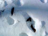 Wolf scat.
 Footprints.
 3D Topo of the
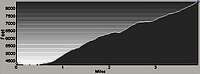 Profile of the