
|
|
Mountain/Rock |
|---|---|
|
|
35.98791°N / 81.77288°W |
|
|
Caldwell |
|
|
Hiking |
|
|
Spring, Summer, Fall, Winter |
|
|
2470 ft / 753 m |
|
|
Overview
If the trail over the summit of Yellow Buck Mountain was the only Above the Falls.
In addition, if there are any wonderful grandstands on Yellow Buck
 Many falls.
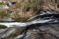
The reason to make the trek to Yellow Buck Mountain is to hike the excellent loop trail that will take you into the Harper Creek drainage where there are a number of excellent waterfalls. Down in the gorge (and it certainly qualifies as a gorge)you can experience a nearly pristine mountain stream decorated with dozens of cascades and several truly impressive waterfalls.
To the east of Yellow Buck is Wilson Creek, another reason to visit the area and the reason that much of the land has been locked up in protection as National Forest and as a National Wild and Scenic River corridor.
And to its credit, the mountain proper is also worth a visit in spring and summer when there is a wealth of wildflowers in full bloom.
 In the Gorge.
Getting There
The easiest way to the parking area if you are coming from Morganton is via Brown Mountain Beach Rd. Traveling north on NC 181, reset your mileage where the 4 lanes goes to 2 lane outside Morganton and go 10.3 miles to Brown Mountain Beach Road. Turn right and continue for 5 miles to SR 1328 and turn left. I've seen this road called both Wilson Creek Rd and a continuation of Brown Mountain Beach Rd. This road turns to gravel and follows Wilson Creek. Drive about 7.5 miles and look for an obvious small parking lot on the left side. This is fairly new - parking used to be along the side of the road. The trail head is marked as #260 and is the Harper Creek Trail. Check your trail map for other access possibilities using different trails. Nice campsites.
Along the easy grade of Harper Creek Trail.
 Map of Loop Route:
Red Tape
None. No fees. Above Harper Creek Falls.
In high use months during the summer, the local police patrol the road and fiercely enforce parking laws. If you park illegally, you will be charged if present, and your vehicle WILL be towed if you are not present. For real.
Camping
There is a National Forest campground called Mortimer that is excellent.There are also hundreds of decent backcountry campsites along the vast trail system at Wilson Creek.
External Links
FRIENDS OF WILSON CREEK.National Forest Wilson Creek Recreation Area site.