Christy, her parents Tim and Julie, and I spent four days exploring the hiker's and scenic paradise of Dark Canyon over Memorial Day weekend. Neither privy to Abajo Mountains snow conditions and road openings nor in possession of a 4WD vehicle, we confined ourselves to the lower canyon from the Sundance Trailhead, accessible by passenger car.
Day 1 - driving, the Sundance trail, and Lost Canyon
We left Salt Lake early Saturday and drove 6+ hours to the trailhead. I had paid insufficient attention to the
good directions on this site so we relied on GPS and maps on Tim's laptop to find our way from UT 95 to the TH. The road was good, only a few negligibly small muddy spots from the week's rain, and though the final spur road to the parking area was rough, Tim's Corolla was up to the task. The parking area was full for the holiday weekend.
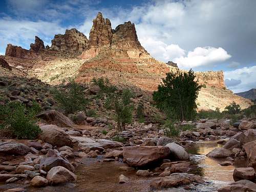
![Lean-To and Dark Canyon from the Sundance Trail]() view from the Sundance trail
view from the Sundance trail
The route follows a seemingly seldom-driven 4WD track then diverges onto a footpath with occasional scrambling to the top of the rockslide. I believe the descriptions of the route down the rockslide exaggerate the difficulties. Strenuous and rugged, yes, but I measured (with compass clinometer) a 45º average slope on a representative section, not 50º, cairns were abundant and mostly unambiguous, the scrambling only occasionally reaches class 3, the exposure is minimal, and at least on a busy weekend the route appears fairly well-traveled.
The obvious campsites where the trail first encounters the stream were occupied, so we hiked up canyon to within 5 or 10 minutes of Lost Canyon. It was 4 hours from the trailhead. We set up camp and then explored Lost Canyon. This was great fun! Lots of scrambling and short climbing problems. Just enough daylight remained to make it to an impassable obstacle (at least, I wouldn't want to try it without a top-rope) and back, though I didn't rule out that there's no way to bypass it with some routefinding on a ledge somewhere.
![Dark Canyon evening]() view from camp
view from campDay 2 - to Young's Canyon
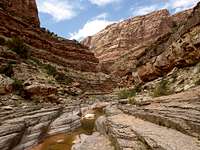
![waterfall in Dark Canyon]() waterfalls and pools
waterfalls and pools![scene in Dark Canyon]() scenery
scenery
We hiked 6 hours (taking our time enjoying the scenery) up Dark Canyon to Young's Canyon, scrambling past many waterfalls, pools, sometimes in the stream channel and sometimes traversing 10 to 50 feet above it, and through interesting geological formations (Paleozoic ones I don't know how to recognize), some of which contained a lot of brachiopod and fragmented crinoid fossils, and chert nodules. Each layer has its characteristic erosional patterns--sloped, ledged, sheer, overhanging, etc., broad or narrow stream channels, which brought variety to the hike: something new around every corner, never a slog.
![fossils in Dark Canyon]() fossils
fossils![flower in Dark Canyon]() flowers
flowersYoung's Canyon has a 20-30 foot waterfall at its mouth that empties into Dark Canyon. Some 4th class climbing just to its right (looking up canyon) got us past it and we wandered a short distance up before returning, finding an easier way down that traversed a ledge around into Dark Canyon to a less steep gully.
![Young s Canyon waterfall]() Young's Canyon waterfall
Young's Canyon waterfall
We returned to camp as the sun was going down.
Day 3 - to the Colorado, and Lean-To Canyon
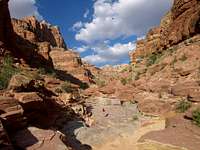
![scene in Dark Canyon]() scenery
scenery![Lake Powell damage]() Lake Powell damage
Lake Powell damage
Tim woke up early and hiked to the northeast rim and back, while we slept in and made breakfast. Then we headed down-canyon. Along the way we passed a caravan of about a dozen hikers; this was probably the most crowded time of year for Dark Canyon. We also ran into a Wasatch Mountain Club group; I recognized a guy named Don I had met last year on the
Bullion Divide.
The lower part of Dark Canyon is bigger, and the stream bottom is more impenetrable, cutting "subways" between waterfalls with no room to hike in the gorge next to the water, except between impassable obstacles. The route therefore traverses a narrow ledge on a cliff with some 30 feet of exposure which, with my camera hanging in front of me (thus getting in the way) and pack behind me, filled for both Christy and me for the day and thus almost as heavy as an overnight pack, was nerve-racking to shuffle carefully across, and then climbs hundreds of feet above the canyon bottom and makes an extended traverse on slopes and ledges, at times quite exposed and with some loose rock underfoot. Not for the faint-hearted!
After descending this section, we stopped by a pool for lunch, and Christy and I took a few dips to cool off; this served as our only bath in 4 days. Fed and smelling somewhat better, we continued on another high, sometimes exposed, traverse. One part had us ducking under an overhang while shuffling across a ledge next to a large drop-off. Soon the track descended, and a friction climb down the final ledge had us in the canyon bottom again for the rest of the hike downstream.
The canyon was more open here and before long we were in the midst of a big mess of sediment that was deposited by Lake Powell when the level was higher, then gouged out more recently by Dark Canyon flash floods. Literally topping off the human damage to the canyon were tamarisk thickets growing on the sediment, impeding reasonable access to the Colorado River. Tamarisks are an evergreen species introduced from Africa and Eurasia which outcompete the native cottonwoods and willows while salinizing soils and monopolizing moisture. They are, however, rather pretty. Tim attempted to find a way farther downstream, but was only able to come within view of the Colorado. The rest of us turned back where we could see the lake backwashing into Dark Canyon; for my part, I felt we had reached the end of the wilderness and had no motivation to continue farther only to receive a lesson in human stupidity. Tim caught up with us when we reached our lunch spot and stopped to filter water.
![evening in Lean-To Canyon]() Lean-To
Lean-To![hiking Lean-To Canyon in the evening]() hiking in Lean-To
hiking in Lean-To
We continued up canyon along the high traverse, culminating in returning across the aforementioned narrow ledge, where I became somewhat frightened of falling backward off the cliff when my camera bag was pushing me out from the wall a bit. We arrived at the confluence with Lean-To Canyon tired, but it was still early in the evening, so we took the chance to wander up it. We didn't reach the huge pour-off, but stopped at a little pool and watched a frog play in the water, before heading back to camp, where frogs croaked all around us, sounding remarkably like sheep.
Day 4 - home
Tuesday was for the 4-hour hike back to the trailhead, during which I came down with what must have been food poisoning. Back home when packing, at the last minute I had thrown a ziplock bag of some old protein powder into my pack as a backup in case I had underestimated my calorie needs for the trip. Apparently it had gone bad, so one of our first stops on the drive home was for pepto-bismol. Also picked up some French hitchhikers in Capitol Reef.


Comments
Post a Comment